Kenilworth Castle: Part 2

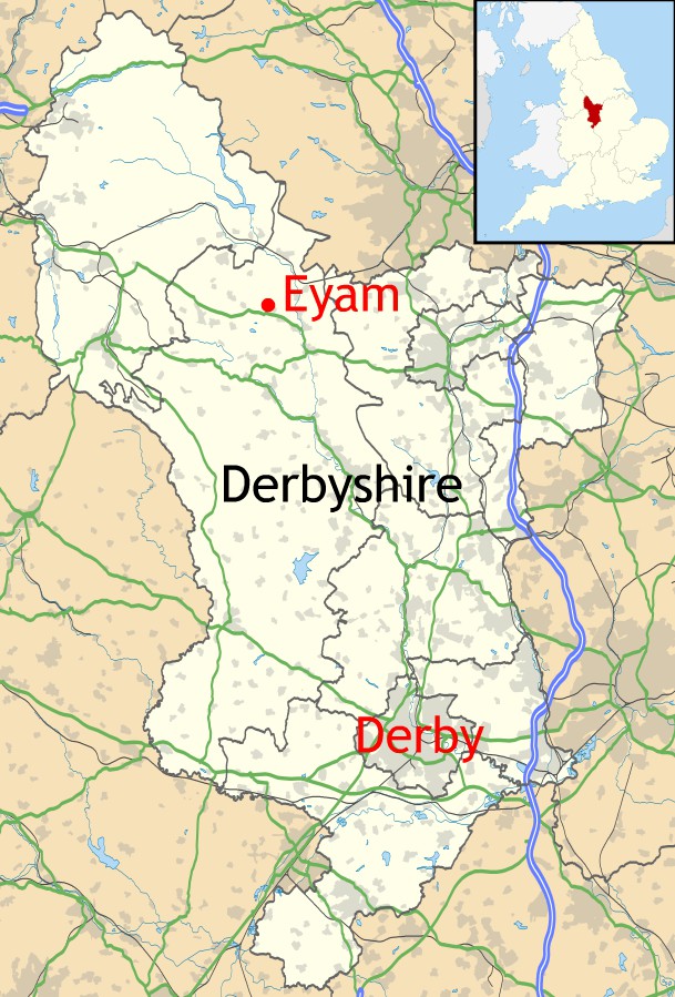
In Part I of this post last week I took a brief look at the history of Kenilworth Castle from its origins in the 1120s to the 16th century when it was given to Robert Dudley, Earl of Leicester by Elizabeth I. In today’s post I want to bring Kenilworth’s history up its slighting in 1650 following the Civil War. To start with, here’s a reminder of the castle’s location in the county of Warwickshire…

Map created by Nilfanion using Ordnance Survey data.  Creative Commons. Annotations are my own.

… and the plan showing the various stages in the castle’s development and growth between the 12th and 16th centuries:

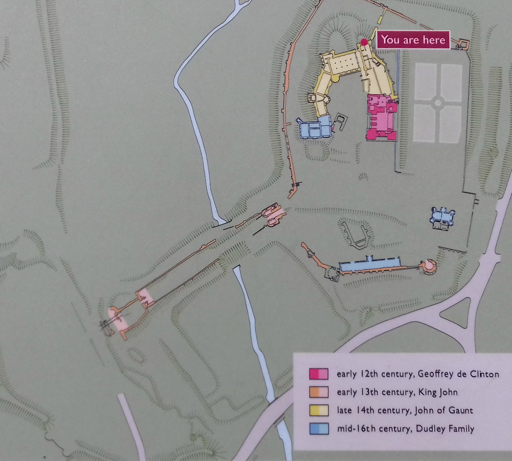
Before I plunge into describing the building works undertaken by Robert Dudley in the 16th century, I want to step back apace and take a look at the actual buildings added by John of Gaunt between 1373 and 1380. In the previous post, I simply mentioned that he’d transformed the fortified castle into a great palace – which is exactly what he did. His new buildings, shown in yellow on the above plan, replaced a succession of earlier ones that had stood on the site, including great halls.

John of Gaunt, the fourth son of Edward III, made certain that family and guests enjoyed comfort and luxury when residing at Kenilworth. His Great Hall was the centrepiece, flanked on the left by spectacular kitchens and the Strong Tower, and on the right by the Saintlowe Tower and State Apartments. The Great Hall was described as the architectural masterpiece of the inner court and was designed to show John of Gaunt’s regal status. This is a reconstruction illustration of what it might have looked like in its heyday:


Designed as a statement of hospitality and display, the Great Hall was where members of John of Gaunt’s family and a hundred and seventy male servants – mostly of aristocratic birth – took their meals. It had a high-pitched roof and very tall windows along the side walls, with six fireplaces. It probably had a raised minstrel’s gallery at the near end of the diagram above.

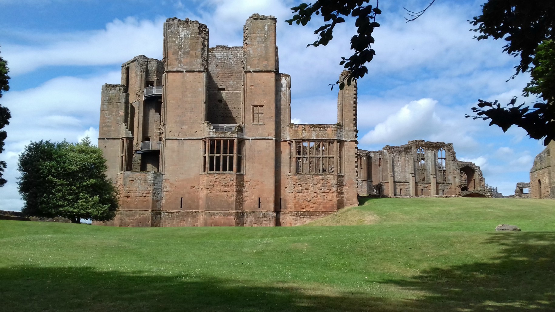
These are a few photos of the ruins of the Great Hall today. The last one shows part of the  Strong Tower to the right.

The kitchens would probably have been mostly timber framed, and have almost disappeared now, but they were twice the size of a normal aristocratic kitchen. It was a long rectangular hall, 66 feet x 28 feet, built against the earlier curtain wall, along which three  huge fireplaces are preserved. The room was top-lit, had a cobbled floor with  a drain in the centre for kitchen waste.

The diagram with the cauldron among the photos below shows a depiction of the kitchen at Windsor  Castle in the 19th century and gives a good idea of what the kitchen at Kenilworth would have looked like. The massive cauldron was used for boiling meat. The little lad in the last photo looks to be perched where an oven would have once been, with the space for the cauldron and steps up to it to his left.

The two towers and state apartment to either side of the hall are interesting to explore and views of surrounding countryside from both are excellent – some  areas of which which would have been part of the mere in John of Gaunt’s time.

I won’t show photos of the towers here, or this post will be far too long, so I’ll finish looking at John of Gaunt’s buildings by saying that his Great Hall must have been extremely impressive as it’s the only one of his buildings that was left unaltered by Robert Dudley 200 years later.

In the previous post, I got as far as describing the changes Henry VIII made to the castle and how, in 1363,  his daughter Elizabeth I, had given it to her favourite, Robert Dudley, Earl of  Leicester. The Stables -now the Cafe and Information Centre, which are also shown in Part 1 – already stood in the Base Court, having been built on the orders of Robert’s father, John Dudley, in the early 1500s.

So after that brief step back in time, I’ll continue with the changes made to Kenilworth by Robert Dudley himself. As shown in the plan above, Dudley’s building works are shown in blue, including his father’s stables. Dudley – or Leicester as he is often called – constructed two fabulous buildings around 1571-2, known as Leicester’s Gatehouse and Leicester’s Building. He also made changes to various other buildings, including the Great Tower/Keep and created the colourful new Elizabethan Gardens.

This photo shows three new, large Tudor-style windows added to the Great Tower to replace the small 12th century ones:

One of his main reasons for such elaborate works was to create a castle fit to receive  Elizabeth I and her entourage in suitable style. The Gatehouse was intended to provide an imposing first view of the castle from the Coventry Road and his magnificent new lodgings, i.e. Leicester’s Building, were simply to impress Elizabeth and provide for her comfort.

Leicester’s Gatehouse straddled the medieval curtain wall and featured an entrance passage at ground level wide enough for carriages to pass through, with two floors of lodgings above. The corner turrets were originally battlemented, a symbolic rather than a defensive structure, as was common with Tudor buildings.

Similarly, the passage was not defended in any way other than by a pair of gates and on both facades there are extensive windows. In 1650, at the end of the Civil War, Leicester’s Gatehouse was a part of the castle that wasn’t slighted and was converted into a private house by Colonel Joseph Hawkesworth, the Parliamentarian who had overseen the castle’s slighting. It remained a private residence for the next 300 years, lived in by a succession of gentlemen farmers. Most rooms in the Gatehouse today are furnished to reflect the style of the 1930s when it was last lived in – which I’ll look at in the third and final part of this  post.

Leicester’s Building was, unfortunately, badly damaged/slighted following the Civil War, but in its day it was an elaborate structure, the size of a compact country house, and it extended beyond the curtain wall. It was four storeys high, but because it’s on the slope of the hill and out over the former ditch, the ground floor and basement were below the principal floor level.

Leicester’s Building was designed to mirror the 12th century Great Tower and Leicester was determined it would equal the old tower in magnificence. He ordered an upper floor to be added to make them similar in height. The ground floor consisted of bed chambers for the queen’s ladies-in-waiting and on the first floor was Elizabeth’s own bed chamber plus outer and inner rooms in which she might meet with her advisors. It is thought that the top floor was a long gallery, where Elizabeth could walk or rest and was possibly used as a dancing gallery. It had huge windows with wonderful views of the surrounding countryside. The first of the two diagrams below shows what the second and third floors might have looked like and the second one gives a closer look at the queen’s bed chamber with her bed against a lost partition wall:

These are a few photos taken at various places around the ruin of Leicester’s Building, many showing views of the surrounding countryside or of other parts of the castle:

Many of Leicester’s new and updated buildings were ready for Queen Elizabeth’s visit in 1572. By the time of her last visit in 1575, Leicester had also created a fashionable Privy Garden to the north of the Keep. It was rumoured that during Elizabeth’s final and lengthy nineteen-day visit (July 9-27) he made his last attempt to win her hand. It was a sumptuous affair that ‘took pageantry to its limits’ with no expense spared on feasts and staged mock battles, plays and other performances, tilting, bear-baiting, ceremonial gunfire, water fetes and, of course, dancing. This famous painting from around 1580 reputedly shows Queen Elizabeth dancing La Volta with Lord Leicester at Kenilworth:

It is well known that in the early days of her reign, Elizabeth was strongly attracted to Robert Dudley and he to her. But the death of his wife, Amy Robsart, in suspicious circumstances in 1560, cooled the affair. (Amy was found at the botttom of a short flight of stairs at Cunnor Place in Oxfordshire with a broken neck and two wounds on her head. Suspicion fell on Dudley, not surprisingly due to his infatuation with Elizabeth – and his desire for more power was well known.) 

To finish with, here are a few photos of the (recreated*) Elizabethan Garden / Queen’s Privy Garden that Dudley had created. It was situated on the northern side of the Great Tower with a raised terrace running across the bottom of the building. It is divided into four quarters, each with an obelisk in the middle and colourful and fragrant with herbs and flowers with grassy pathways between. A fountain of white, Tuscany marble stands in the centre of the garden. It depicts two ‘Athlants’ i.e. Atlantis figures, joined together and holding up the sky. The ‘boll’ discharges jets of water. There are also arbours and an aviary. 

* The Elizabethan Garden we see today was recreated by English Heritage in 2009 from an eyewitness account written by Robert Langham, a minor official, in a letter to a friend. 

…and this is a photo showing what Kenilworth Castle might have looked like around 1575-80 after all Leicester’s work, including the Elizabethan Garden:

*

References are listed on Part 1 of this post.

The Great Orme Copper Mines

The Bronze Age Copper Mines located in Llandudno on the Great Orme headland are one of Britain’s most important archaeological sites. Excavation began in 1987 and since then over 5 miles of tunnels dated between 1860BC and 600BC have been surveyed. The mine was opened to the public in 1991, enabling visitors to see the great complex of tunnels and old surface workings. We have visited three times now, the last time being in 2017, so I thought it was about time I wrote a post about it.

Great Orme Location Map

The Great Orme headland, or peninsula, is a massive chunk of limestone, rising to 207 metres /679 feet out of the sea. Its name, Great Orme, is of old Scandinavian origin, Ormr meaning serpent and hofuth meaning head. So the headland was called Serpent’s head, and it isn’t hard to see why.

Llandudno_&_Great_Orme anotated
1024px-Conwy_UK_location_map
It is possible that the site of the mine was already a special place before anyone realised that the green copper ore could be turned into metal. It is thought that the 5,500-year-old Neolithic/Stone Age burial chamber only 100 metres from the mine was constructed there because the area was a closed, dry valley in which water disappeared down a sink hole.

Entrance to the mines is through Reception with a friendly piece of advice about wearing suitable shoes:

Entrance to the Great Orme Mines

Notice at the entrance to the site

The first part of our visit was around the large area of surface/opencast mining, which was all buried underground until excavations began in 1987.  The first opencast mining started approximately 4,000 years ago in places where the green malachite ore was visible at the surface. The malachite would probably also have been useful to the people for its colour as a pigment, perhaps for paint or eye make-up.

Open Cast Mining 2
Artist’s impression of the opencast workings as they may have appeared

Opencast mining probably continued for around 200 years, during which hundreds of tonnes of ore was extracted. When surface deposits were exhausted miners had no other choice than to follow the tunnels below ground. The little Bronze Age man on some of the photos was our guide through the mine, keeping us updated with interesting snippets of information.

The route through the tunnels for visitors has been carefully excavated since 1990. It reveals openings to previously unknown areas of the mine – many of which are too small to walk through.

Information poster at the entrance to the underground mines

Carbon dating in the Great Cavern in the central section of the mine suggests that it was mined in the middle of the Bronze Age, 3,500 years ago. It would have produced an enormous tonnage of copper metal. It is a huge cavern and so dark that it is illuminated by bright lights further in.

Early Bronze Age miners would have had a number of tools available to them. Around 3000 stone hammers have been unearthed since 1987. These were made from some of the hardest rocks, like dolorite, diorite and basalt, most lumps of which would have been found washed up on the beach. Battered markings on the hammers give evidence to the fact that the rock being worked was also fairly hard. When it was too hard to be worked with tools, a process called fire-setting was used. A fire was lit against hard areas of rock, causing it to crack. As with the use of animal fat lamps in the tunnels, fire-setting was hazardous as it burnt valuable oxygen.

Later in the period, tools were made of bronze:

Over 35,000 animal bones have been found at the mine, including cows, sheep, pigs, deer, dogs and rodents. Some of them would have been used for food, others by the earlier miners as chisels and scrapers in the mines.

The only Bronze Age smelting site in Britain was on the Great Orme.  As shown in the images below, copper ore was first broken into small fragments with stone hammers  before being fed into the kiln fuelled by charcoal, which burns at a much higher temperature than wood. The ore was changed into metal by heating it at temperatures around 1,100 degrees centigrade – which they wouldn’t have been able to measure, so I imagine they would simply get the furnace as hot as they could. The process is called smelting. Miners soon realised that on its own, copper ore is soft, and that by mixing it with 10% of tin they could produce the harder metal, bronze. The molten metal was poured into moulds and used to create a variety of objects.

As well as tools and weapons of all types, including spears, daggers, swords and shields, bronze could be made into many things, such as cups, cauldrons and the items named in to image below:

The many uses of bronze

This next image shows how broken or damaged metal implements were re-melted and re-cast into new ones:

There is plenty of evidence to show that an extensive trade network was in place during the Bronze Age.  The nearest source of tin needed to make Bronze on the Great Orme was Cornwall, 300 miles away. During the mid Bronze Age (3,500 years ago) a distinctive type of axe was made in North Wales. Hoards of these axes have been found in France and it is believed that the Great Orme copper was the main source of metal used. The metal has also been found in artefacts across Europe, stretching from Brittany to the Baltic.

Bronze Age boats found in Britain  suggest that trade was conducted by sea. The boats were capable of carrying cargoes of up to 2 tonnes and would have been able to cross the English Channel to France or Holland.

Bronze Age Travel
The mines on the Great Orme would have brought wealth and power to those who controlled them and the people of the Great Orme flourished with them.

Copper mines brought wealth and power to those who controlled them

Bronze Age copper mining on the Great Orme finally stopped when they reached the water table, by which time iron was the new material and the demand for copper declined. After a very long lull in interest, during which the mine seems to have been almost forgotten, there was a renewal during the Industrial Revolution in the 18th and 19th centuries. Water was pumped out and shafts were sunk down to 470 feet (sea level). But eventually, Llandudno became known more as a popular Victorian seaside town than a mining town. The mines were covered over by spoil at the end of the 19th century and once again forgotten.

Although a great deal of excavation has already taken place since 1987, archaeological work will continue on both the surface and underground workings for decades. Tens of thousands of mine waste still cover large areas of the early mine workings and who knows what else will be discovered about this amazing site.

Visitor Centre
The Visitor Centre provides plenty of information about the site, including a short introductory film, a model Bronze Age village, rock and ore specimens area and colourful posters around the walls to explain all about Bronze Age life on the Great Orme and working in the copper mines. The latter were the source of the snippets I’ve used in this post.

This year (2020) the copper mines re-opened on July 25, working to guidelines from the Welsh Government, including social distancing, a one-way system and face masks when viewing underground. Entry fees are £8 for adults, £5 for children and under 5s free. In 2005 the Great Orme mines was awarded the title of ‘The Largest Prehistoric Copper Mines in the World’ by the Guinness World Records Team and I can say that it’s well worth a visit.

References:

The Great Orme Bronze Age Mines Guide Book, purchased at the site

Information boards in the visitor centre and around the site

The Great Orme Copper Mines, Llandudno, Wales – Historic UK

Base map of Conwy, North Wales from Nilfanion at Wikipedia

Aerial photo of Llandudno and the Great Orme from Harvey Milligan at Wikipedia


The Canal Pond and Emperor Fountain at Chatsworth

The Canal Pond is set in the South Lawn at Chatsworth and was dug in 1702-3. It is set a few inches higher than the lawn, creating the illusion that the house rises out of the water when viewed from the far end of the canal.

chatsworth-house-736070_1920
Image by Johnnie Shannon from Pixabay

There had been a fountain at the north end of the canal since the pond was completed. Originally named the Great Fountain, it is flanked by two reclining river gods, created by the sculptor Nadauld. The gods can just be seen in this photo, one of them behind a lady photographing the dog structure:

Canal pond showing 2 gods and dog structure

When it became known that Tsar Nicholas 1, Emperor of Russia, would visit Chatsworth in 1844, the Great Fountain was replaced by the Emperor Fountain. Commissioned by the 6th Duke and created by Joseph Paxton, it was so named as a welcoming gesture to the tsar. Unfortunately, Tsar Nicholas never did make that visit but the fountain kept the name anyway.

Tsar Nicholas of Russia
Portrait of Emperor Nicholas 1 by Franz Kruger (1797-1857). Housed in the Hermitage Museum in Saint Petersburg. Creative Commons/Public Domain

Although the original Great Fountain had been the highest in the country, the new Emperor Fountain exceeded its reach and is on record as having reached 90 metres/295 feet. It was powered by the pressure of water dropping 297 feet through a 16 inch cast-iron pipe. It was the tallest gravity-fed fountain in the world for 160 years.

To provide enough water to power the new fountain an 8-acre lake, aptly named Emperor Lake, was dug up in the surrounding moorland of the Peak District. (This was in addition to the three existing lakes already providing the immense volumes of water needed by the house and its surrounding grounds.) Emperor Lake was finished in only six months in 1844.

The following painting, which I used in my earlier post on Chatsworth House, gives some idea of the height of the land behind the house and grounds:

Chatsworth_from_Morris's_Seats_of_Noblemen_and_Gentlemen_(1880)
A late 18th century oil painting by William Marlow. It emphasises the romantic aspects of Chatsworth’s setting on the edge of the Peak District. Public Domain

If you look closely at the hillside, you will spot a small building. That is the hunting lodge, situated in Stand Wood on the edge of the hills and moors of the Peak District. Emperor Lake can be seen from the lodge, should visitors choose to wander up there.

A two and a half mile channel was dug across moorland to gather rain that fell on the high ground. As mentioned above, the fountain was powered by the pressure of water dropping 297 feet through a 16 inch cast-iron pipe. In places, trenches up to almost 15 feet deep were cut through the rock to maintain the gradient.

In 2014 two new nozzles were made for the fountain. One is the same diameter as the original nozzle and the other is a little narrower, the aim being to create a column of water similar to the one that Paxton achieved. With the new narrower nozzle and a new debris grid in Emperor Lake, which supplies the water, the fountain can still reach 62 metres/200 feet on a still day.

Although this may not be the most attractive fountain in the world, the height it reached so long ago and the story about Tsar Nicholas, certainly make it interesting.

***

This is the second part of a post I wrote a few weeks ago about Chatsworth House in Derbyshire. The first part was already rather long, so I thought I’d leave this short piece for another time.

A final note: Writing this has set off a discussion in our house about the spelling of tsar. I’ve always spelled it this way, but my husband argued that if should be czar. Well, after looking it up it seems there are three spellings of the word: tsar, tzar and czar. So it seems to be a case of ‘take your pick’!

Steampunk Festival 2019

024

Over the Bank Holiday weekend last year (August 23-26) the world’s biggest Steampunk festival returned to Lincoln for the 11th time. Held along the cobbled streets of the Cathedral Quarter, in the grounds of Lincoln Castle and in parts of Bishop Grosseteste University, the festival celebrates the steam powered world of the late nineteenth century and attracts people from all over the world. A number of events keep visitors entertained over the three days.

This was our first visit to the festival and we didn’t realise what a fun event we’d been missing. In fact (being from the Stone Age ourselves) we weren’t entirely certain what steampunk was all about. So for anyone else similarly uncertain, here a a few definitions:

First, from The Ministry of Peculiar Occurrences: http://www.ministryofpeculiaroccurrences.com/what-is-steampunk/

Steampunk is an inspired movement of creativity and imagination. With a backdrop of either Victorian England or America’s Wild West at hand, modern technologies are re-imagined and realized as elaborate works of art, fashion, and mechanics. If Jules Verne or H.G. Wells were writing their science fiction today, it would be considered “steampunk.”

Second is this one from: Steampunk Avenue blog: https://steampunkavenue.com/en/blog/what-is-steampunk/

Steam is a central element of steampunk. The technology featured in this universe is generally just as advanced as that of our modern world, but it uses steam as its energy source instead of electricity, gas or oil. As a result, steampunk technology takes on a retro look reminiscent of the Industrial Revolution era. As Douglas Fetherling so aptly put it, “Steampunk is a genre that imagines how different the past might have been had the future come earlier.”

We saw some interesting looking machines and vehicles in and around Lincoln Castle that day. These are just a few of them:

What about the punk in steampunk? This explanation is from the Asylum Steampunk website: https://www.asylumsteampunk.co.uk/what-is-steampunk/

Can you still call it steam-PUNK?  Punk in the seventies was a rebellion against contemporary society.  We are most definitely rebelling but we are making a stand against: throwaway society, poor manners and antisocial behaviour, homogenisation and commercialism.  We are punks who are polite, friendly, care about the environment and the past and encourage creativity.

Steampunk style decoration on a stall

The costumes are terrific and so creative, and in Lincoln – as I imagine there are in many cities and towns – there’s at least one shop that sells ready-made costumes for steampunks. Several people we chatted to had made their own costumes. With temperatures of 31-33 degrees (Celsius) it must have been unbearably hot inside some of the costumes, especially for those wearing gas masks and other weird head coverings, or items of clothing such as thick cloaks and coats, long boots or tight corsets!

We also saw this character wandering around chatting to everyone. By golly… it’s Captain Jack!

There were plenty of stalls selling steampunk clothing and other items, in both the castle grounds and around the Cathedral and the top of Steep Hill:

One of the main events of the day was the Parade, featuring a very young Queen Victoria and a variety of individuals and groups, including nurses and soldiers – even some mounted on their trusty steeds (i.e. dinosaurs). Visitors lined the road through the castle grounds to watch the procession walk there and back – and guess who we spotted amongst the spectators:

We were hoping to go again this year, but unfortunately all events are cancelled. I can only hope things are back to normal by August 2021.

Parasols out on a hot day


Saltaire

Built between 1851 and 1876, the Victorian model village of Saltaire is located in Shipley, a commuter suburb and small town in the City of Bradford Metropolitan District in West Yorkshire, UK.

Location of Saltaire in West Yorkshire
Base map courtesy of Wikipedia

The name Saltaire is derived from the surname of industrialist, entrepreneur and philanthropist, Sir Titus Salt, who had the village built, and the River Aire which flows through it.

Every year, hundreds of visitors come to Saltaire to visit the village itself, and/or take a look round Salts Mill, the woollen ‘supermill’ that Titus Salt had built in the town. To do justice to both village and mill ideally takes (at least) a whole day. There is much to see and plenty of places where visitors can buy drinks, snacks or meals when required – both around the village and inside the mill.

Saltaire is situated by the River Aire, the Leeds and Liverpool Canal and the Airedale railway line, all ideal for the import of raw materials for Salt’s woollen mill and export of the manufactured goods.

Plan of Saltaire
Map photographed from a information board in Saltaire

Titus Salt cared about the welfare of the workers for his planned new mill on the edge of Bradford. He wanted to create a community in which they could live healthier and happier lives than they had in the slums of Bradford, where cholera epidemics were frequent. Saltaire was 3 miles from central Bradford and surrounded by open countryside with plenty of fresh air. In addition to these evident health benefits, Salt installed the latest technology in his mill, intending working conditions for his workers to be far better and safer than they were in mills elsewhere in the country. Undoubtedly, such improvements would also benefit output from his mill.

Salt employed local architects Henry Lockwood and Richard Mawson to design his new village. The first building to be finished in 1853 was the mill itself, while building work on the rest of the village continued until 1876.

When the mill opened in 1853, on Titus Salt’s 50th birthday, he threw a huge party for all his workforce. It was the biggest factory in the world, four storeys high and the room known as ‘The Shed’ measuring 600 feet in length. The mill employed 3000 workers and had 1200 looms. Over a period of twenty-five years, 30,000 yards of cloth were produced per day. The noise from the machines would have been deafening and the workplace very hot. Yet working conditions for employees in Salt’s Mill were still far better than in most other textile mills.

The following photos of the working mill  were taken from a video playing inside the mill:

Salt’s enormous success in the textile industry was partly due to his use of the wool from alpacas. He combined it with other materials to create new varieties of worsted cloth. Wool worsted cloth as well as wool/cotton and wool/silk worsted cloths already existed for making men’s suits. In Salt’s day it was fashionable for ladies clothing. Most ladies would have wanted (but many couldn’t afford) expensive silk – and Alpaca made a light, smooth fabric with the lustre of silk, but was more affordable.

alpaca-2907771_1920
Alpacas, courtesy of Pixabay

Architecture in the village was of a classical style, inspired by the Italian Renaissance. The rows of neat stone buildings were all terraced, arranged in a grid pattern. All streets were named after members of his family, such as Caroline Street after his wife. In total there were 823 houses, shops, a school, two churches, a school an adult education institute, park, hospital, and almshouses for the aged. The streets also had gas lamps.  Each house had its own outdoor toilet – a luxury for the working classes in of the nineteenth century.

Salt also had a wash house and baths built in the village, the wash house because he objected to seeing lines of washing hanging in the back yards. Dirty washing could be brought to the wash house on Mondays to Thursdays. There were six washing machines powered by steam engines and four rubbing and boiling tubs using hot and cold water. Clothes were put through the wringing machine and dried in a drying closet before being mangled and taken home. The whole process took an hour.

Wash House Interior
Photo taken from and information board at the community garden in Saltaire

There were 24 baths for public use with separate entrances for men and women. There was even a Turkish bath. The baths were open every day but Sunday from 8am to 8pm. Salt’s care for the health of his workers is evident but, unfortunately neither wash house nor bath house was popular and the building was converted into housing in the late 19th century. The houses were demolished in the 1930s and replaced by garages which were demolished in the 1950s. The site is now a small community garden.

Saltaire Congregational Church (now the United Reformed Church) was one of Lockwood and Mawson’s finest works and is set in a spacious landscaped garden. Salt was a staunch Methodist and insisted his workers attended chapel on Sundays. He also frowned upon gambling and the drinking of alcohol. A mausoleum beside the church is where Titus Salt was buried.

The Victoria Hall is also worth a look inside:

Robert’s Park, alongside the River Aire is a pleasant, open space to spend a little time. The alpaca statues are a reminder of the importance of their wool to the continuing success of Titus Salt, whose statue is also in the park.


Salts Mill closed as a textile mill in 1986 and was bought the following year by Bradford entrepreneur, Jonathan Silver who had it renovated. Today it houses a number of business, commerce, leisure  and residential concerns. The main mill is now an art gallery, shopping centre and restaurant complex. There is a fish restaurant and Salts Diner, a cafe which serves a variety of dishes.029

Eating inside the mill

The 1853 Gallery takes its name from the date of the building in which it is housed and it contains many paintings by local artist David Hockney. A bust of Titus Salt welcomes visitors through the door.

Today, Saltaire is a popular place to visit, as an educational experience or simply e a lovely village in which to spend some time. Families come for many reasons, and boat rides along the canal seemed popular on the day we were there. Oddly enough, one of the boats was called Titus. I wonder why…

Boat rides on the Leeds and Liverpool Canal

World Heritage status was bestowed upon Saltaire in 2001. It is described on an information board in the village:

World Heritage status from a noticeboard in Saltaire

Our visit to Saltaire was three years ago now. We had planned to go back again sometime this year. But as they say, ‘All the best-laid plans of mice and men…’  Perhaps next year, then…

Refs:

  1. Information boards around Saltaire
  2. Wikipedia
  3. My Learning

The Plague Village of Eyam

Eyam is a village in Derbyshire, U.K. and lies within the Peak District National Park:

Location of Eyam in Derbyshire
The village was founded by the Anglo-Saxons and, as in many limestone areas of the Peak District, lead had been mined in the vicinity since Roman times.  In the early and mid-17th century, the industry employed many of Eyam’s inhabitants.

Today the pretty Derbyshire village attracts visitors from around the world, not only due to its location within the National Park, but because of its fame as ‘the plague village’. In addition, hundreds of visitors flock into Derbyshire from spring to autumn each year (though not this year!) to see the fabulously ‘dressed’ wells in many of the villages, Eyam being one of them.  I did a post about Well Dressing here

The plague that hit Eyam in 1665-1666 is referred to as ‘The Great Plague’. It was not ‘The Black Death’ – the outbreak of plague that reached England in 1348. The plague that occurred in both periods was basically the same bubonic plague, the different names denoting the different times in which it struck. In the 300 years between the two, numerous other outbreaks of plague occurred across the country and some small settlements disappeared altogether.

Bubonic plague is a disease carried by several rat species, most commonly the black rat, also known as house rat or ship rat.

Plague rat
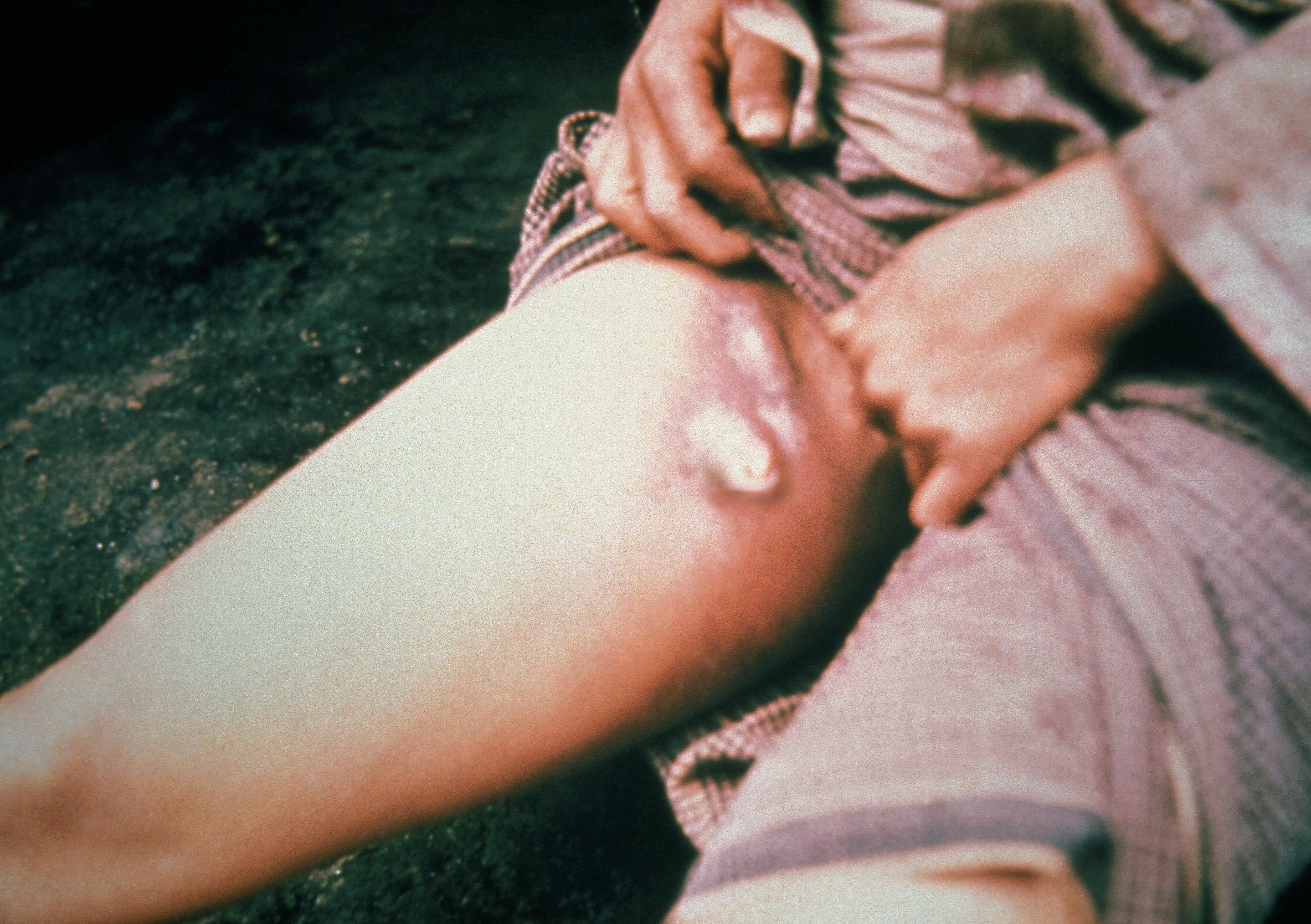
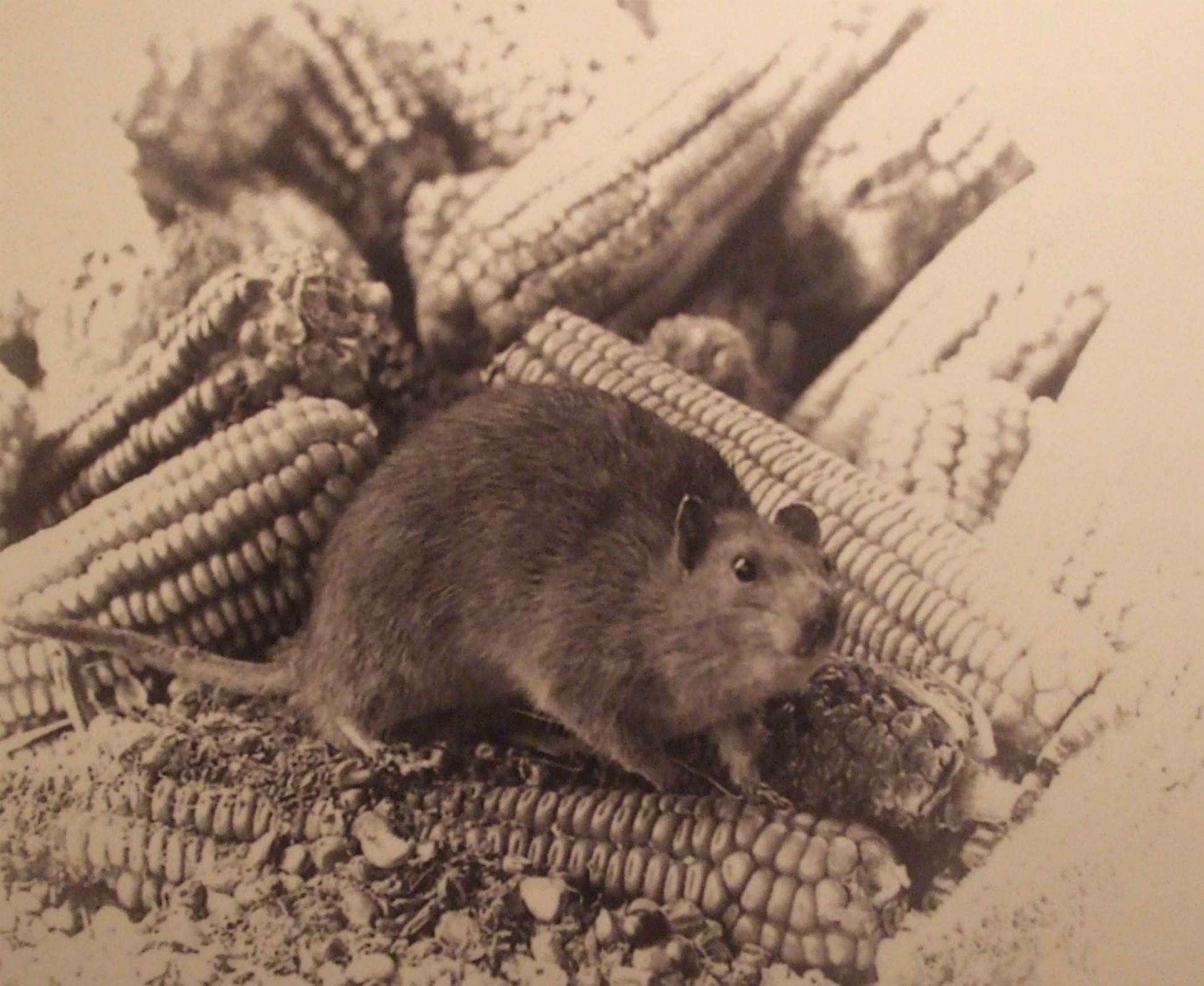
The fleas that live in the rat’s fur are carriers of plague bacilli and when they feed on the rodent’s blood they leave the bacilli in its body, causing rapid death. If the number of rats plummets, infected fleas will take the blood of humans or other small mammals.

Plague Flea 2

In London alone in 1665-6, almost 70,000 deaths were recorded during this outbreak of plague, though it is thought the real number was closer to 100,000. Many towns and villages across England also suffered. In Eyam, 260 of the estimated population of 1,000 died.

The plague in Eyam is believed to have been caused by fleas that had got inside a bale of cloth brought to Eyam from London for a travelling tailor’s assistant named George Viccars who was lodging with Mary Hadfield and her family. When he unfolded the cloth it was damp, so he laid it out to dry – and the plague-carrying fleas jumped out.

George Viccar with his bale of cloth

George became the first man to die of the bubonic plague in Eyam. More deaths soon followed and within days, the disease had spread through the village, affecting many households.

The most well-known effect of bubonic plague are the buboes, the massive, tender swellings which form in the lymph nodes, generally in the armpits or groin:

Plague_-buboes
Plague patient displaying a swollen, ruptured inguinal lymph node, or buboe. Image courtesy of the Centers for Disease Control and Prevention’s Public Health Image Library. Public Domain

There are various other effects, too – fever, vomiting, headaches and delirium being just a few of them. The lungs can also become infected, causing pneumonic plague. This is less common but much more dangerous, due to the ease in which it can spread through sneezing. A third form of the disease is believed to be septicaemic plague, a life-threatening infection of the blood.

Having no scientific knowledge enabling them to account for the outbreak of the plague, to the villagers the disease could only be explained in religious or supernatural terms. The wrath of God inflicted upon sinful people could only be pacified by prayer and repentance. Many devout villagers refused to take preventative measures for fear of angering God further. Others relied on herbal and other age-old remedies. Between the September and December in 1665, 42 villagers died.

Remedies 4

Remedies 2

There is no record of how many villagers actually left Eyam and it is now believed the number was higher than originally thought. But it is known that most were wealthy landowners and mine owners – all of whom would have had somewhere else to go.

Wealthier people fled from Eyam

A few families sent just their children away to safety, as did William Mompesson, the recently elected reverend, and his wife, Catherine:

Children being sent from Eyam 1

Few of the poorer, tenant farmers and labourers could abandon their livelihoods and just pack up and leave, but in a bid to escape almost certain death, a few  poor people chose to try their luck elsewhere. Some built makeshift homes on nearby Eyam Moor or in fields or on hillsides.

Some poor people also fled

There is also plenty of evidence of poorer refugees of the plague being barred or violently driven away from their chosen places of refuge. The people of the city of Sheffield, approximately 15 miles away, erected barriers and posted guards. The picture below shows an Eyam woman being chased out of the nearby village of Tideswell as she attempted to mingle unnoticed with shoppers at the market.

Woman from Eyam being chased out of Tideswell

Mortality rates over the winter 1665-66 saw a drop, primarily due to the rats nesting in warm places like thatches on the roofs. There would also be ample foods for the rats in the unhygienic homes of the times. Comfortable, warm rats would provide plenty of food for the fleas, so they would have no need to seek out alternative sources of blood.

Nevertheless, death rates were still well above the normal winter average, and since the villagers knew that plague was a summer disease, the number of deaths was expected to increase with the rise in temperatures in the spring of 1666. After a slight lull in casualties in the May, a sudden and dramatic increase occurred in June, and it became clear to the newly appointed reverend, William Mompesson, that something needed to be done. Together with a former rector of Eyam, Stanley Thomas, a three-fold plan was devised.

Firstly, there would be no more organised funerals and church burials. Families would be responsible for burying their own dead in their gardens, orchards or fields.

Carrying out the dead

Secondly, the church would be locked and future services held in the open air.

030

The third part of the plan was the greatest and toughest of them. A ‘cordon sanitaire’ would be imposed around the village in an attempt to stop the disease spreading further afield. In other words, the village would be quarantined – a condition to which all villagers needed to give their consent. Quarantine would mean that, shut away from the world, many people in the village would meet the inevitable end.

Mompesson promised to do all in his power to get essential foods and medications into the village. A boundary stone was erected, separating Eyam from the nearby village of Stoney Middleton. The stone had specially made holes in its top, which were filled with vinegar, which acted as a disinfectant.  Eyam villagers could put their money into these holes in exchange for supplies. The stone is still in its original place today and visitors can find it by following the signs around the village. 

Boundary stone 2

In addition, in exchange for their promise of obeying the cordon, the Earl of Devonshire from nearby Chatsworth House, freely donated foods and medications to the people of Eyam. These were left at a place known as Mompesson’s Well. 

Collecting food from Mompesson's Well 2

The highest number of deaths was recorded in August 1666, as many as 5 or 6 deaths per day. In the heat of the summer, the fleas were more active and the disease rapidly spread. Households became deserted, communal tasks left unfinished and cattle wandered unattended. Nevertheless, few people attempted to leave (only 2 known). Elizabeth Hancock buried her husband and six of her children, though she remained unaffected herself. Their graves are known as the Riley Graves, after the name of the farm on which they lived.  Like the boundary stone, these graves can be visited today.

Burial close to own home 2

William Mompesson’s wife, Catherine, worked tirelessly, visiting the sick until falling victim to the plague herself in late August, 1666.  Her tomb can be seen in the churchyard.

Catherine Mompesson's tomb

By Christmas 1666, after 14 months and the deaths of 260 people, it was all over. Life in the village slowly began to return to normal. In an effort to stop further outbreak of the pestilence the following summer, there was ‘a great burning’ of everything in Eyam that could have harboured the ‘plague seeds’. Mompesson set the example by burning everything of his own except the clothes he was wearing.

Great burning after the plague at Eyam 2

To finish with, here a few photos we took around the village. With the exception of the one buboes (which is from Wikipedia) those shown above were all taken in the little Eyam Museum, which is well worth a visit.

Also of interest, with plenty of information about the Great Plague at Eyam, are Saint Lawrence’s Church, and the Plague Cottages.  Eyam Hall – which is a 17th century, grade 2 listed historic house – is also well worth a visit. In the churchyard are Catherine Mompesson’s tomb and a fabulous Anglo-Saxon Cross dating from the 8th-9th century.

Inside the church, there is a famous stained glass window depicting scenes connected to the plague and a record of those who died from the disease.

Plague window inside Eyam Church

A Visit to Creswell Crags

20190519_121350

From spring to autumn of most years we have a day out on a Sunday, visiting scenic or historical sites which are close enough to drive to and enjoy in a single day.  We’ve been to Creswell Crags many times and at various times of year, and it’s always worth a visit. So, because we haven’t been able to go anywhere at all this year, I thought I’d show some photos of Creswell from our day out in May 2019 and add a little bit of information about the attractions and importance of the site.

Creswell Crags is a beautiful magnesian limestone gorge situated on the border between Nottinghamshire and Derbyshire in England.

Location of Creswell Crags

It is popular with families, walkers and horse-riders as well as academics interested in the appearance and use of the gorge and its caves in the distant past. The route down to the lake (i.e. the widened stream) from the Reception is a pretty area with delightful trackways with picnic areas, open meadows and children’s play areas.

The ‘YOU ARE HERE’ in the plan below is to the side of the Reception / Visitor Centre.

20190519_104512

The gorge itself is known throughout the world as an outstanding Ice Age archaeological site. It was designated as a Site of Special Scientific Interest (SSSI) in 1981 and as a Scheduled Ancient Monument in 1985. The caves were seasonably occupied during the Upper Paleolithic and Mesolithic periods (from around 11,500 – 6,000 BP) and there is evidences of Neanderthal, Bronze Age and post-medieval activity.  The caves  contain the northernmost cave art in Europe as well and a series of 17th and 18th century witches marks.

20190519_110959

The gorge provided a valuable summer camp for our Ice Age ancestors. It was a place where people could meet, there was food to hunt nearby and caves in which to shelter and prepare for their return to their winter territories across Doggerland to mainland Europe.

Doggerland connected Brtian to Continental Europe at the time when waters of the sea were frozen during the Ice Age
A hypothetical map showing Doggerland connecting Britain to Continental Europe at the time when waters of the sea were frozen during the Ice Age. Author Max Naylor, February 2008 Creative Commons

There are six main caves along the gorge at Creswell Crags in addition to many smaller fissures and solution hollows. Excavations in the larger caves have provided a rich fossil record, “a time capsule spanning thousands of years”. Neanderthals visited 55,000 years ago, as did the earliest, modern humans 29,000 years ago. Remains of various animals have been found. Before the Ice Age, exotic animals like hippopotamus and rhinoceros wallowed in the warm waters of the river that flows through the gorge. As the climate cooled to Ice Age conditions, lions and hyenas used the caves as dens, and were joined by woolly mammoth, woolly rhinoceros and reindeer. Skulls and other bones of various species can be seen in the small museum at the Reception – including lions, hyenas, bears, woolly rhinoceros and mammoth, plus several smaller mammals.

Here are a few photos taken of the caves and general views during our walk around the lake:

Hunter gatherers continued to use the caves long after the end of the Ice Age. Burnt hazel nut shells, cattle bones and small flints have been found. 6,000 years ago the caves were used for burials. Urns have been found as have bronze pins,which were used to hold the burial shroud. A human collarbone was found in Church Hole Cave.

Hundreds of protective marks, known as witches’ marks, have been discovered in caves at Creswell. They date from medieval to modern and are scratched into walls and ceilings over dark holes and large crevices. Originally thought to be graffiti, they are now believed to be the the largest collection in the UK.  Prior to their discovery, the largest collection was held to be in Somerset, with 57 marks. The number at Creswell far exceeds that number – there are hundreds in one cave alone.

Ritualistic protection marks were most commonly found in historic churches and houses, usually near to entrances such as doorways, windows and fireplaces, to protect the people living there from evil spirits. The most common sign is VV, believed to refer to Mary, Virgin of Virgins. The one shown below is not from Creswell. We didn’t go inside the caves last year when the Witch Marks tour was opened for the first time.

shutterstock_1726383430

Another common symbol is PM, referring to Pace Maria. Other signs, include diagonal lines, boxes and mazes. Many appear to have been added over time, possibly indicating a need to strengthen protection in periods of unexpected sickness, death or crop failure.

Although closed at present due to Covid-19 restrictions, Creswell Crags is usually open all year. There is no cost to walk round or visit the shop or cafe. Entrance to the exhibition/museum is £3 and cave tours start at £9 for adults and £7 for children. for a single cave.


Beautiful Bodnant

080This week, I am away from home (with Husband, of course) staying at a hotel in Chester, very close to the Welsh border. This is an ideal place from which I can visit my family in Lancashire and Wales as well as revisiting some of the wonderful castles along the North Wales coast and the Roman and medieval sites around the city of Chester itself.

Oddly enough, our first visit was to somewhere quite unplanned. Whilst visiting my aunt and uncle at Penrhyn (in the county of Conwy) along the coast of North Wales, we decided to take a trip to Bodnant Gardens, nestling in the foothills of Snowdonia, just five miles inland from their house.

Bodnant has been described as one of the world’s most “magical” gardens. The scenery is quite dramatic and there are historic plant collections and awesome trees. Every season presents wonderful species and the changing colours are spectacular.

062

A single post could not do justice to the history and evolution of the Gardens, and even today, expansion and improvement continue. Regarding the history, I will simply summarise things by saying that Bodnant Hall was built in 1792 and was landscaped with native trees:

032

A mill was built down in the Dell (valley) to serve the needs of the estate, but it was not until the Hall was bought by industrialist Henry Pochin in 1874, that the gardens began to really take shape. It was he who planted the giant conifers in the Dell, created the famous Laburnum Arch and built the Poem Mausoleum as a resting place for himself and his family.

Since Pochin’s time the Gardens have considerably grown and new species continuously introduced. Plants were brought back by 19th and early 20th century explorers, including towering American redwoods and gorgeous Himalayan primulas, poppies and lilies.

The Gardens were first opened up to the public by Pochin’s daughter Laura, following her father’s death in 1895. On Laura’s death, management of the gardens passed to her son, Henry McLaren and stayed within that family until 1949 when they were handed over to The National Trust.

We’ve visited Bodnant several times before, at different times of the year, and have always been delighted with the displays. This month, the blooms are spectacular and I’ve never seen the Laburnum Arch look better. My aunt particularly loves the many different varieties of roses.  Here are some photos we took:

On this occasion we didn’t manage to get down to the Dell, as my aunt was having problems with a sprained ankle, so we stayed relatively close to the Hall and the different gardens there. The following photos show some of the displays and views we saw. The Laburnam Arch was absolutely stunning. And yes, it’s me and Husband ambling along inside…

My next post will be about the first of the wonderful Welsh castles we visited. We’ll be back home on Sunday, so the others will be done sometime next week. Well, that’s the plan…

Just Who Was Saint Valentine?

 471px-St-valentine-baptizing-st-lucilla-jacopo-bassanoValentine was a Roman priest during the reign of Emperor Claudius the Second in the third century AD. He is sometimes known as Claudius the Cruel – and is not the Emperor Claudius who was responsible for ordering the building of Hadrian’s Wall across the North of England in AD 122-130.

The story tells us that Claudius believed that married men did not make good soldiers. They worried too much about leaving wives and families behind if they were killed to be truly effective in battle. So Claudius issued an edict, prohibiting the marriage, or engagement, of young people.

Now, Roman society at this time was very permissive, and polygamy was popular. Yet some of the people were still attracted to the Christian faith. Unfortunately for them, since the Christian Church taught that marriage was sacred between one man and one woman, this posed a problem. It was obvious that something had to be done about it . . .

It was Valentine who set about encouraging people to be married within the Christian community, despite the emperor’s edict. Naturally, ceremonies were performed in secret.

Valentine was eventually caught, imprisoned and tortured. A man called Asterius, whose daughter was blind, was called to judge him. Valentine is said to have prayed with, and healed, the girl – which caused Asterius himself to become a Christian. Whatever the outcome of that, somewhere around the year AD 270 Valentine was sentenced to a three-part execution: beating, stoning and eventual beheading. Whilst in prison, awaiting execution, Valentine is said to have written a note to Asterius’ daughter. He signed it . . .

From your Valentine

. . . thus inspiring today’s romantic cards.

shutterstock_246610336

*

Some interesting points about Saint Valentine:

  • Like many stories set so long ago, this one is often questioned. The main problem stems from Valentine’s true identity. According to the Catholic Encyclopaedia, there were at least three different St. Valentines, all of them martyrs. A second one was a bishop of Interamna (now Terni, Italy) and the third, a martyr in the Roman province of Africa. It is possible that the first two are the same person. However, the confusion surrounding Valentine’s true identity caused the Catholic Church to discontinue liturgical veneration (public worship) of him in 1969, although his name remains on its list of officially recognised saints.

Valentineanddisciples
St. Valentine of Terni oversees the construction of his basilica at Terni. Attribution: Public Domain Wikimedia Commons

  • Valentine’s flower-adorned skull is on display in the Basilica of Santa Maria in Cosmedin, Rome. Excavation of a catacomb near Rome in the 1800’s yielded the skeletal remains, and other relics, now associated with St. Valentine. As is customary, various bits of these remains have been distributed to reliquaries around the world: Czech Republic, Scotland, England, France and Ireland:

382px-St-valentine_110921-01
Shrine of St’ Valentine at Whitefriar Street Carmelite Church in Dublin. Attribution: blackfish

  • No record exists of romantic celebrations on Valentine’s Day prior to a poem written by the medieval poet, Geoffrey Chaucer, in 1374.  It is called ‘Parliament of Foules’. In this, he links a tradition of love with the celebration of Valentine’s Feast Day. The poem refers to February 14th as the day on which birds (and humans) come together to find a mate:

For this was sent on Seynt Valentyne’s day

Whan every foul cometh ther to choose his mate…’

*

I won’t go on about the ways in which Valentine’s Day is celebrated today. There are lots of posts out there with little poems and stories. I’ll just finish off with a few pictures appropriate to a few of the things we associate with the celebration today.

shutterstock_125184527

(Header image: 1600’s painting of St. Valentine baptising St. Lucilla.  From Wikimedia Commons. Public Domain.)

Forsooth, Sir, Canst Thou Not Speak More Plainly?

shutterstock_217997104
Egads, mistress, art thou addressing me?

The style of language to adopt when writing historical fiction is a topic that keeps authors continuously arguing. Readers, too, have their own strong opinions as to whether a novel’s language is suited to the period in question. The main issue, of course, is whether or not the words sound too modern for the time. We hear comments like, ‘People in sixteenth century England would not have used those words.’ And in some cases, they are correct. We only need to check the derivation of the word to find out.

It’s very easy with everyday items. We all know, for example, that cars, trains and planes should not make an appearance in the sixteenth century. Nor washing machines, duvets or a million other things that we take for granted today. Not to mention electricity pylons across the countryside!

shutterstock_102673817
An sight unknown on the ancient landscape

But when it comes to general word use in a story, things are not as simple as that.  Language is constantly evolving. New words are added as technological advances are made. Other words become obsolete. And, of course, populations evolve. Immigration and emigration are nothing new. The English language is basically composed of a mixture of Celtic, Latin, Anglo-Saxon, Norse, and Norman. But during the last seventy years in particular the massive scale of immigration into Britain, for example, has added many other words to the language – as indeed it has cultures. I know the United States can claim the same.

When all’s said and done, novelists are out to tell stories – and those stories must be accessible and interesting to readers. A novel set in Tudor times littered with thees, thous, wilts, hasts and forsooths and so on, would soon become . . . well, in my opinion, absolutely comical. We have many TV comedy sketches to back that up.

Naturally, this doesn’t mean that the writer should resort to phrases such as, ‘What yer playin’ at buster?’ or, ‘Henry looked a right charlie in that hat.’ Gross exaggerations, of course, just to make a point, but such phrases would look no more out of place in a novel about Henry VIII than a string of egads and forsooths. 

shutterstock_130331855
Old language must be translated to be understood

What I believe most writers of historical fiction aim for is something close to a happy medium. A sprinkling of skilfully placed authentic historical terms will not appear ridiculous, whereas too many would do. Perhaps it’s all a question of style. A writer must set the correct tone for the period yet still move the story along in an engaging manner that modern readers can relate to.

Some years ago I read a short article by Michael Jecks, who’s written many historical fiction novels, many of them murder mysteries. Most are set in the Middle Ages. In the article, Jecks discussed criticism he’d had from reader(s) who considered the language used in his books to be inaccurate for the time. His answer was excellent. He simply pointed out that in the Middle Ages, the language used was totally different to that of modern times (basically Anlglo Saxon with a sprinkling of Celtic, Latin, Norse etc: in other words, Middle English) which today, only scholars of the period would understand.

More recently I found a YouTube presentation by Michael Jecks on the same theme. Here’s the link for anyone interested.

I’m sure that most historical fiction authors already do work along the lines Jecks outlines here. I know that I have tried to do so in my own two novels, Shadow of the Raven and the soon to be completed, Pit of Vipers.

One of the funniest things I’ve read on this subject was in a ‘Writing’ magazine back in the nineties. The author of the article was an editor, who told of the worst example of historical inaccuracy he’d ever come across in a work submitted to him in hope of publication. The novel was about Mary Queen of Scots. Although my wording may not be absolutely accurate (I read it a long time ago) it is certainly very close. In this scene, Mary supposedly says to her husband, Darnley:

‘Darnley, honey, let me fix you a chicken sandwich.’

Any comments on this fascinating subject would be very welcome.

*****