Beaumaris Castle

Aerial view of Beaumaris Castle on Anglesey, Wales: By Cadw, Wales
Aerial view of Beaumaris Castle, on Anglesey, Wales: By Cadw, Wales

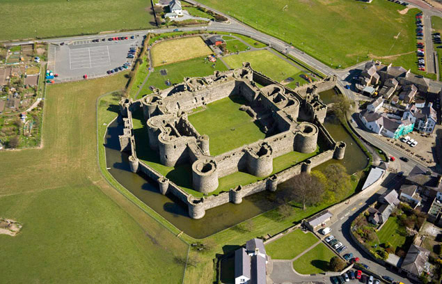
Beaumaris was the last of the three castles I visited on my trip to North Wales two weeks ago. It is situated on the Island of Anglesey across the Menai Strait and reached by the road bridge. There is also a rail bridge, and both bridges get a fair amount of traffic, especially in the summer months. Tourists come to visit Anglesey itself or to get to Holyhead for the ferry across to Ireland.

North Wales Castles

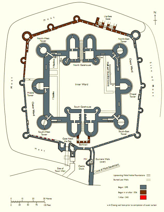
Begun in 1295, Beaumaris was the last of the royal strongholds to be built by Edward I in Wales, so completing the ring of fortresses he had begun in 1277. By 1295, King Edward had built or refurbished 16 castles, and it seems that the one at Beaumaris had been planned as early as 1283.

Yet it was not until twelve years later that work began on the ‘fair marsh’ – Beau Mareys in Norman-French. Initially, great progress was made with the building. In the first year, 450 masons, 400 quarrymen and 2,000 labourers worked to dig the moat and begin constructing the towering walls.

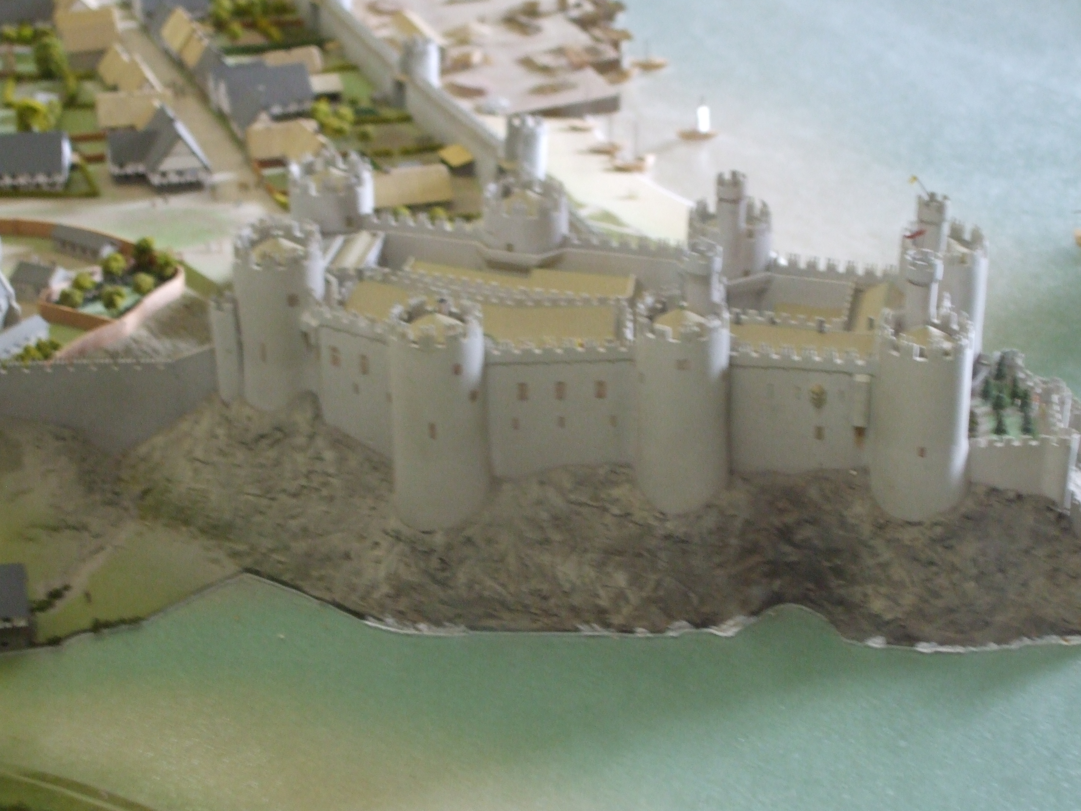
Like the castles at Rhuddlan, Aberystwyth and Harlech (and unlike those at Conwy and Caernarfon, where the shape was determined by the contours of the underlying rock) Beaumaris took advantage of the flat site and was designed in the concentric plan. The main courtyard /inner ward is surrounded by a narrow encircling ward and both are then protected by an outer moat with a controlled supply of tidal water.

beaumaris_plan_cadw (2)

Below are a few views of the outer walls, the moat (with resident swans and their cygnets) and the main entrance (called ‘The Gate Next the Sea’). Alongside this gateway is the castle dock, where boats would have moored while their cargoes were unloaded directly into the outer ward.

The gateway itself was defended in three ways. First was the drawbridge across the moat, which would be raised at the first sign of alarm. Then there was the portcullis, the grooves along which this would have operated can be seen on two of the photos above. Above the inner passageway were the ‘murder holes’, one of which can be seen in the middle photo on the last row, above. Through these, attackers who succeeded in getting through the two outer defences would have met with boiling oil, as well as a barrage of arrows through arrowloops along the passageway wall. Lastly was a heavy, two-leaved door.

Today, the castle is approached across a wooden bridge over the moat instead of a drawbridge, and through the main entrance into the outer ward. These are shown on the larger photo, top left, above.

There are several information posters around the site. This one below is about the outer ward. If you’re good at reading Welsh, try the information at the right hand side! Note the interesting snippet and ‘view through the wall’ diagram showing castle loos (bottom left illustration):

The inner gatehouse – through to the inner ward – was defended by three successive pairs of barrel gates and portcullises. It was sited deliberately off-line to force attackers into exposing their left flanks to archers waiting along the top of the inner gatehouse and wall.

The symmetry of the castle is impressive (as evident on the above plan) although the skyline has been described as visually disappointing. It lacks the turrets of Caernarfon. Conwy and Harlech and has a definite squatness that fails to dominate its surroundings. This is because, although the work went on for 35 years, when it finally ceased in the 1330s, the towers of the inner ward were still without their top storeys and the planned turrets were never even started. There were plans for 5 separate suites of lavish accommodation, 3 of which remained unfinished. Unfortunately, Edward simply ran out of money.

Here are a few photos of the inner ward and a couple looking out from the top of the inner wall over the Menai Strait toward mainland North Wales. The seagull was also nesting along the top of the inner wall.

Beaumaris Castle has relatively little recorded history. Any sieges it had to withstand were not the kind to add much to its story, as those at Harlech. Like all the North Wales castles, it was held for the king in the civil war (1642-49) and surrendered to Parliament in 1646. Some partial works of demolition were carried out after that war, but most of the original structure has remained standing until the present time.

Next time I go to North Wales, I’ll be aiming for the castles at Harlech, Rhuddlan (which is just a ruin) and Chirk. I camped in the grounds of Chirk Castle many years ago, when I was a robust Girl Guide at the age of thirteen. Happy memories!

***

Castles of North Wales: Conwy

800px-Conwy_Castle_and_car_park_from_Town_Walls_-_geograph.org.uk_-_1723358
Conwy Castle and car park from the Town walls, viewed from the south west. Source: geograph.org.uk. Author: David Dixon. Creative Commons

The castles of King Edward I (1272-1307) in North Wales are amongst the finest medieval buildings in Britain. They were all built from scratch, often concurrently, in the unsettled aftermath of war. During my trip to Wales last week I’ve been to see just three of these castles. The simple map below shows their locations. Beaumaris is on the Island of Anglesey, across the Menai Straits:

North Wales Castles
Map showing three North Wales castles. Base map from Image:uk map,svg. Author: Paul at wts.wikivoyage. Wikimedia Commons.

Conwy Castle was built on a new site in the spring of 1283 as part of a ring of fortresses encircling the Welsh heartland of Snowdonia in Gwynedd. It followed Edward’s victory of his second campaign to subdue the Prince of Wales, Llwelyn ap Gruffudd. There had been conflicts in this region for many years between the Plantagenet kings of England (John 1199-1210 and Henry III 1216-72) and the princes of Gwynedd – notably Llwelyn ab Iorwerth, also known as Llwelyn the Great. (ab/ap are derived from the Welsh word mab, which means ‘son of”.)

Neither John nor Henry challenged the Prince of Gwynedd successfully, and on Edward’s succession in 1272 the prince’s refusal to do homage to the English king resulted in the war of 1276 -77. Edward’s victory was rapid – if, ultimately, inconclusive – but his second war (1282-3) proved more decisive.

The castle was built as part of a wider project to create the walled town of Conwy in order to control an important crossing point over the River Conwy. The whole project cost £15,000 – equivalent to £45 million today. The castle was intended as a centre for the administration for the area, but Caernarfon became the shire town and assumed that role. Edward only stayed at Conwy once.

Here are a couple of pictures of a model on display inside the castle. They show the castle and part of the walled town as they would have originally looked. Note the direct access to the River Conwy:140

144

The plan below shows the castle from the same (south) side as the last picture. The plan is roughly rectangular, with four towers spaced regularly along each side. The bulging outer (south) wall can be seen clearly on each, probably the result of the builders following the contours of the rocky outcrop. The great hall and chapel in the outer ward curves in line with this wall. The four towers closest to the river have small, round turrets overlooking the inner ward, where the royal apartments were located.

800px-Conwy_Castle_plan
Conwy Castle plan. Source: Cadw. Open Government Licence. Wikimedia Commons.

The castle is noted for its high towers and curtain walls, and its excellent state of preservation:

Inside the imposing outer shell the castle contains the most intact set of residential buildings left by medieval English monarchs in Wales or England. The outer ward – 2/3 of the main castle area – contains the great hall and chapel, as well as the chambers, stables and kitchen that served the garrison.

This is the outer ward. The two photos, bottom left are of the great hall and chapel. The chapel is at the far end, where the arched window can be seen.

The inner ward has the private chambers (top left photo below) and the royal chapel. A water gate, leading to the east barbican (gateway) provided private access for the king and queen. Here are some photos taken mostly from around the battlements, with an odd one or two inside the towers. Most look down into the inner and outer wards, or show views out across the River Conwy:

The suspension bridge ascross the R. Conwy (middle bottom) was designed by Thomas Telford and completed in 1826.

I’ve missed out so much detail about Conwy Castle, as well as many of the photos we took, otherwise this post would become a marathon.

Beautiful Bodnant

080This week, I am away from home (with Husband, of course) staying at a hotel in Chester, very close to the Welsh border. This is an ideal place from which I can visit my family in Lancashire and Wales as well as revisiting some of the wonderful castles along the North Wales coast and the Roman and medieval sites around the city of Chester itself.

Oddly enough, our first visit was to somewhere quite unplanned. Whilst visiting my aunt and uncle at Penrhyn (in the county of Conwy) along the coast of North Wales, we decided to take a trip to Bodnant Gardens, nestling in the foothills of Snowdonia, just five miles inland from their house.

Bodnant has been described as one of the world’s most “magical” gardens. The scenery is quite dramatic and there are historic plant collections and awesome trees. Every season presents wonderful species and the changing colours are spectacular.

062

A single post could not do justice to the history and evolution of the Gardens, and even today, expansion and improvement continue. Regarding the history, I will simply summarise things by saying that Bodnant Hall was built in 1792 and was landscaped with native trees:

032

A mill was built down in the Dell (valley) to serve the needs of the estate, but it was not until the Hall was bought by industrialist Henry Pochin in 1874, that the gardens began to really take shape. It was he who planted the giant conifers in the Dell, created the famous Laburnum Arch and built the Poem Mausoleum as a resting place for himself and his family.

Since Pochin’s time the Gardens have considerably grown and new species continuously introduced. Plants were brought back by 19th and early 20th century explorers, including towering American redwoods and gorgeous Himalayan primulas, poppies and lilies.

The Gardens were first opened up to the public by Pochin’s daughter Laura, following her father’s death in 1895. On Laura’s death, management of the gardens passed to her son, Henry McLaren and stayed within that family until 1949 when they were handed over to The National Trust.

We’ve visited Bodnant several times before, at different times of the year, and have always been delighted with the displays. This month, the blooms are spectacular and I’ve never seen the Laburnum Arch look better. My aunt particularly loves the many different varieties of roses.  Here are some photos we took:

On this occasion we didn’t manage to get down to the Dell, as my aunt was having problems with a sprained ankle, so we stayed relatively close to the Hall and the different gardens there. The following photos show some of the displays and views we saw. The Laburnam Arch was absolutely stunning. And yes, it’s me and Husband ambling along inside…

My next post will be about the first of the wonderful Welsh castles we visited. We’ll be back home on Sunday, so the others will be done sometime next week. Well, that’s the plan…