Kenilworth Castle Part 3: Decay and Restoration

This is the third and final part of my post about Kenilworth Castle (which I started with every intention of finishing in a single post!). So before I plough on, here is the map, showing where Kenilworth Castle is located in the U.K.

And this is the plan that shows the growth of the castle between the 11th and 16th centuries:

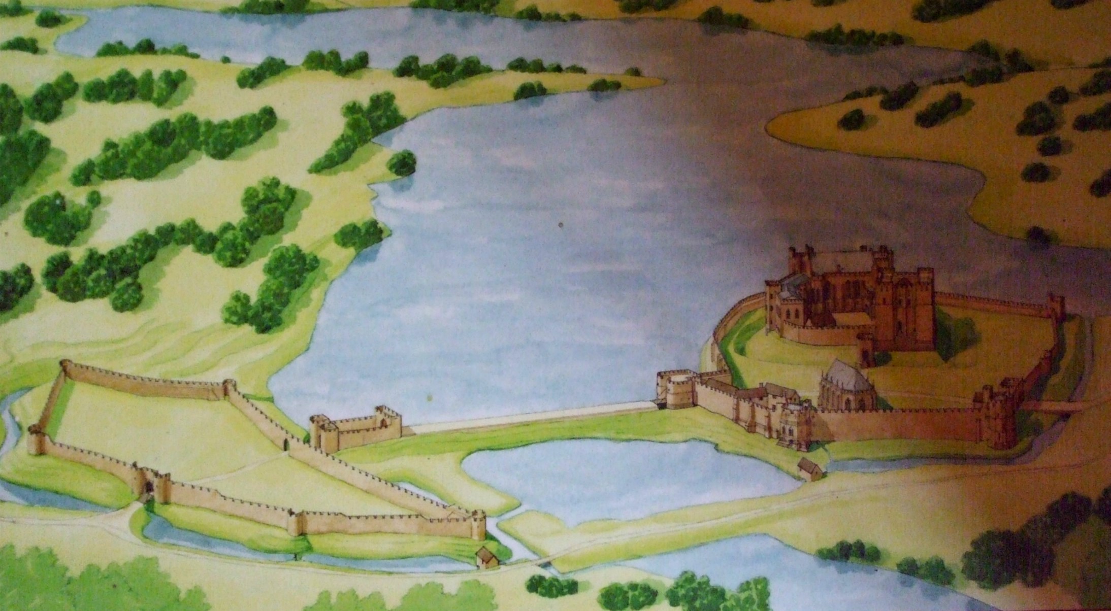
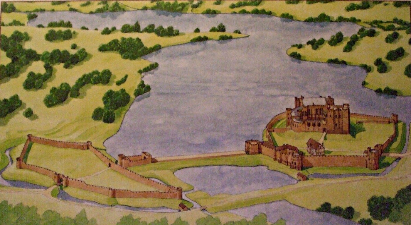
I finished Part 2 with the work completed by Robert Dudley, Earl of Leicester, in the 16th century, and in this post I intend to look at what happened to Dudley’s fabulous castle (plan below) in the years following his death until the present day.

Having no  legitimate heir, on Dudley’s death Kenilworth Castle passed to his brother, Ambrose. However, family wranglings over ownership gave James I the opportunity  to take the castle back into Crown hands in 1603. In 1611, King James’ son, Prince Henry, agreed to pay huge sum of £14,000 for full title to the castle. On his death the following year, Kenilworth passed to his brother, Charles: the future Charles I. The buildings were well maintained,  and several royal visits took place, until the outbreak of the Civil War in 1642.

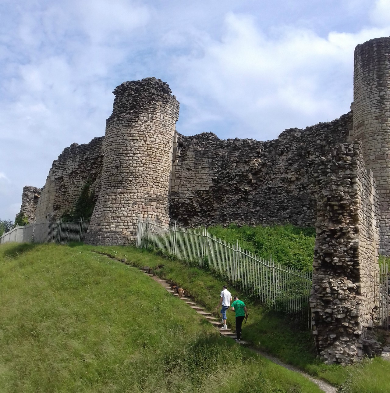
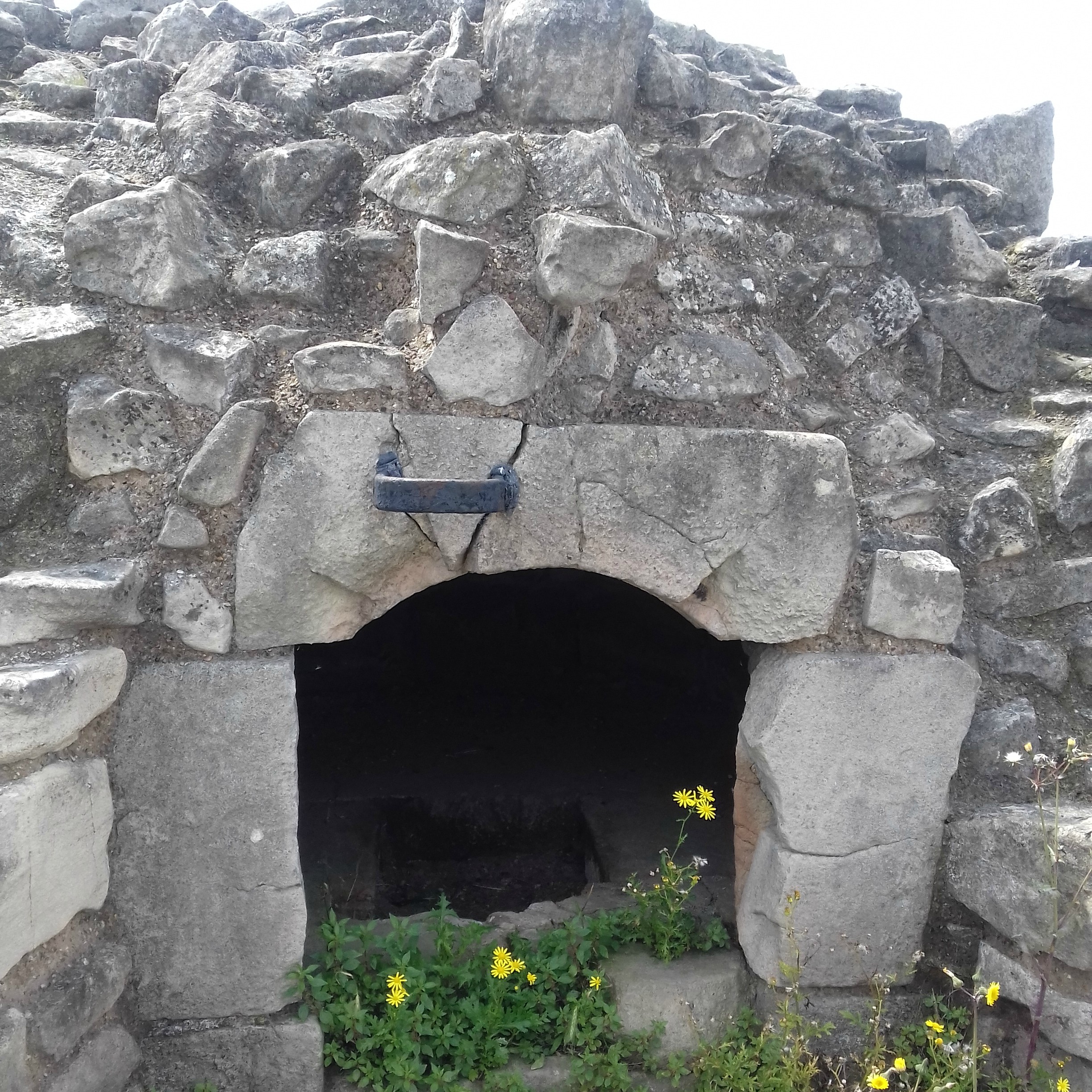
Following the Battle of Edgehill in October 1642, King Charles withdrew the Royalist garrison from Kenilworth. The castle was occupied by Parliamentarians and remained largely untouched for most of the Civil War. But the uprisings of 1648 and the imprisonment of Charles I, brought about a change in  Parliament’s attitude to all former Royalists strongholds.  In 1650 Kenilworth was slighted (cannoned) along with many other castles across the country. All buildings in the Inner Court were severely damaged leaving Leicester’s Gatehouse along the Outer Curtain Wall the only building to remain intact.

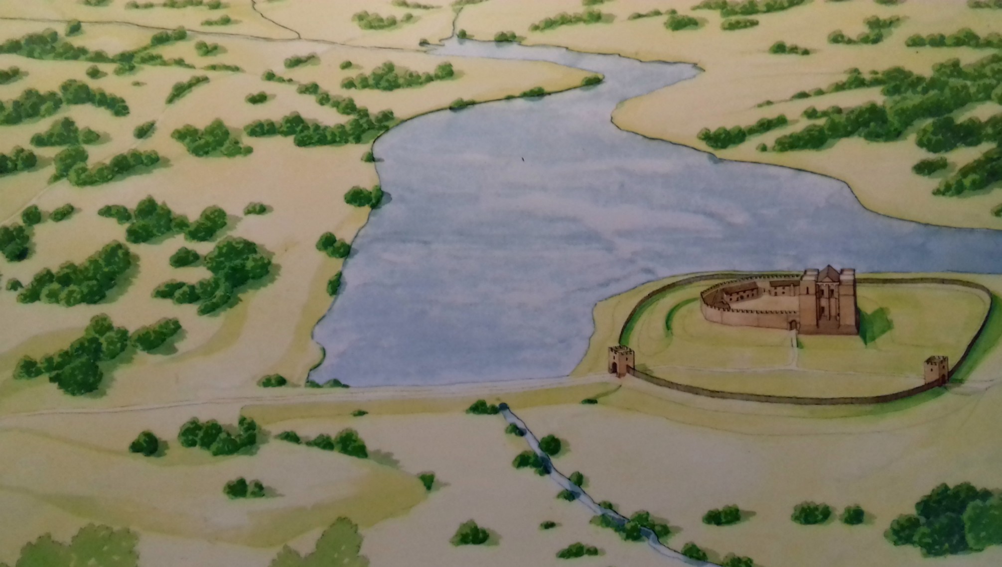
This photo of a reconstruction drawing shows the possible state of the castle between 1650-60 following the slighting. The mere was also drained at this time and the Inchford Brook returned to its natural course through a culvert in the dam. (A culvert is a tunnel carrying a stream or open drain under a road or railway.)

The castle and estate were acquired by Colonel Joseph Hawkesworth, the Parliamentarian who had overseen the slighting. He had Leicester’s Gatehouse turned into a residence for himself with a  farm in the Base Court. Fellow officers divided the estate into farms and pillaged the castle’s buildings in the Inner Court for their building materials. Hawkesworth had the passageway into which coaches would enter the building blocked and the space converted into a hall/dining room.  He also added a gabled extension, which became the kitchens and where the wooden stairs up to upper floors can be found. A classical porch was added to the west of the building, too.

With the Restoration of Charles II in 1660, Hawkesworth was evicted and the castle restored to Charles’ mother, Henrietta Maria, and for a short time, the stewardship of the earls of Monmouth. It continued to pass through a  number of nobles over the next two hundred years until it came to Thomas Villiers who became Earl of Clarendon in 1776. Kenilworth remained with the earls Clarendon until 1937. Their tenants lived in Leicester’s Gatehouse using the buildings in the Base Court as a farmyard.

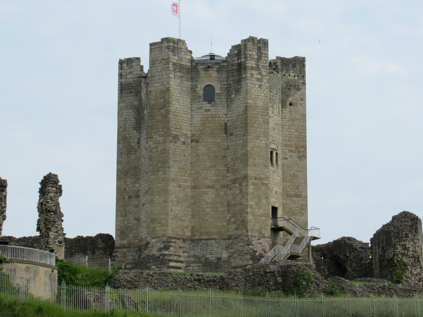
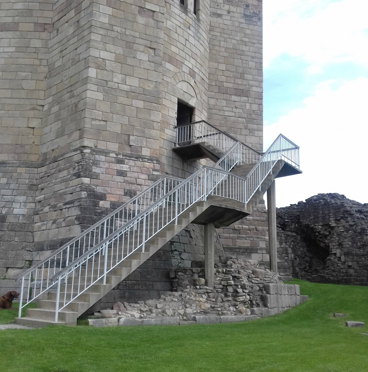
By the later 18th century, tourists had begun to take an interest in the ruins and the first guidebook was published in 1777.  But by the start of the 19th century, the buildings had been allowed to seriously decay, and in 1817, thirty tons of stone crashed down from the north-west turret of the Great Tower/Keep, making it a very unsafe place to visit.

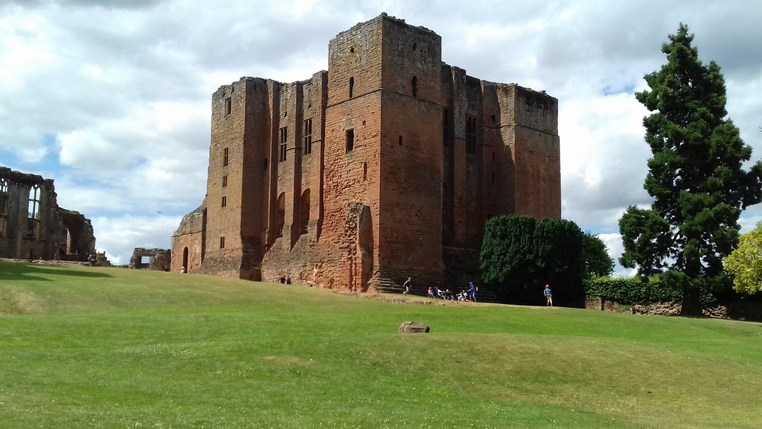
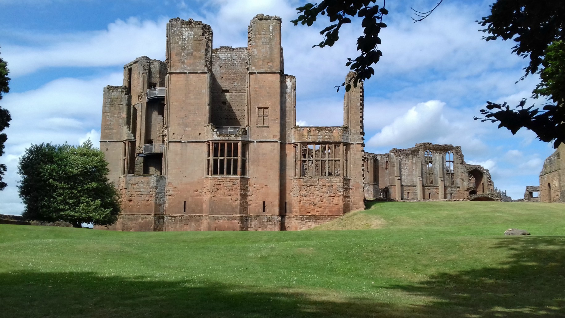
The Great Tower today:

In 1821, Sir Walter Scott published a romantic novel titled, Kenilworth, which generated huge public interest in the castle. The novel tells of the sudden and suspicious death of Amy Robsart, Dudley’s first wife, against the backdrop of Queen Elizabeth’s famous visit to Kenilworth in 1575 – despite the fact that Amy died in 1560. After the book’s publication, Kenilworth Castle became a major tourist attraction and by the time Scott returned to the castle in 1828, he found it much better preserved and protected.

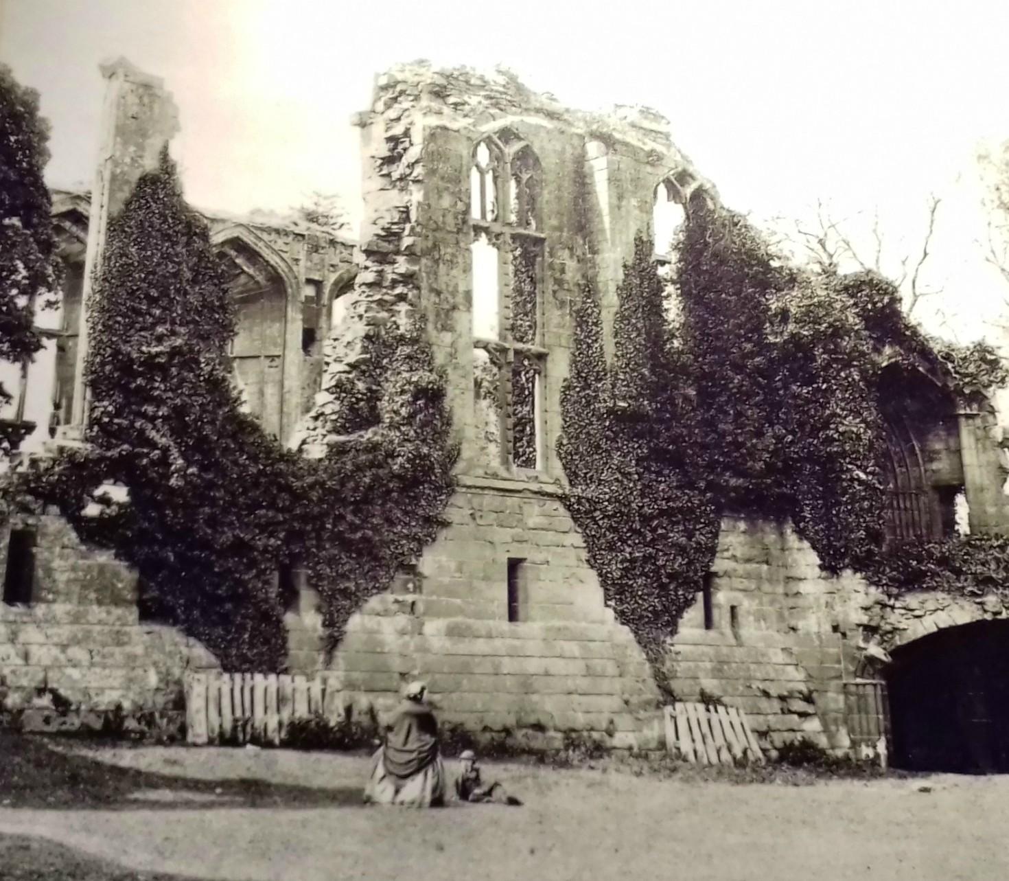
This 19th century photo (also used as my featured image) shows John of Gaunt’s Great Hall as a pictuesque, ivy-covered ruin. it is believed that the ivy was killing the deterioration of the medieval building.

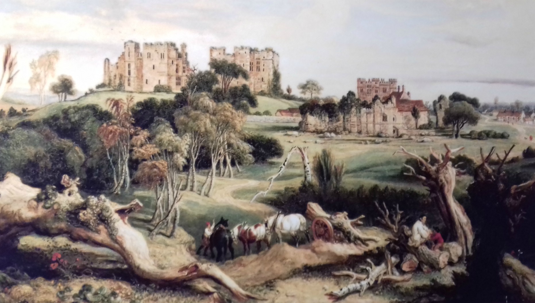
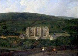
This idyllic scene showing the whole castle as an ivy-covered ruin, was painted by James Ward in 1840:

Substantial clearance of rubble and some restoration work was done in 1860 and more in the late Victorian era, including the rebuilding of lost walls, but by the 1920s, the 6th Earl of Clarendon was finding it difficult to pay for all the maintenance. Fortunately, in 1937, the castle was purchased by Sir John Davenport Siddeley, a pioneer of the motor industry and later 1st Baron of Kenilworth. In 1938, he placed it in the hands of the State and gave a large sum of money towards the cost of repairs.  Since 1984, Kenilworth Castle has been managed by English Heritage.

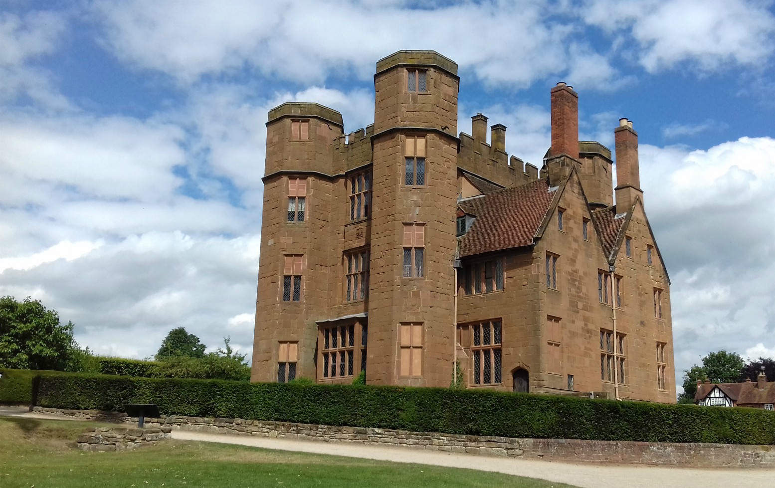
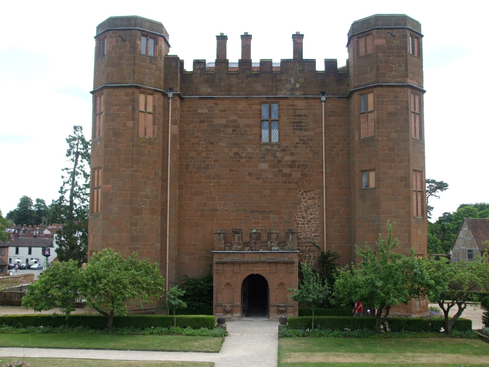
Leicester’s Gatehouse was lived in until the 1930s and today’s visitors  can see the ground and first floors decorated and furnished as they would have been then. The top/third floor houses a display depicting Robert Dudley, Earl of Leicester and Queen Elizabeth’s last visit to Kenilworth in 1575. There are also information boards and photographs showing Siddley’s career and the vehicles produced by him from the early 20th century until his death in 1953.

There are two ground floor rooms, one being the dining room, the other the southern or south room. The rather blurry photo is of the dining room in the 1930s and the small gallery shows some of those same pieces of furniture that are still in the room today:

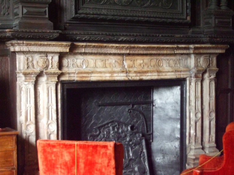
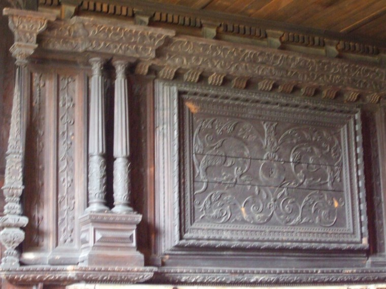
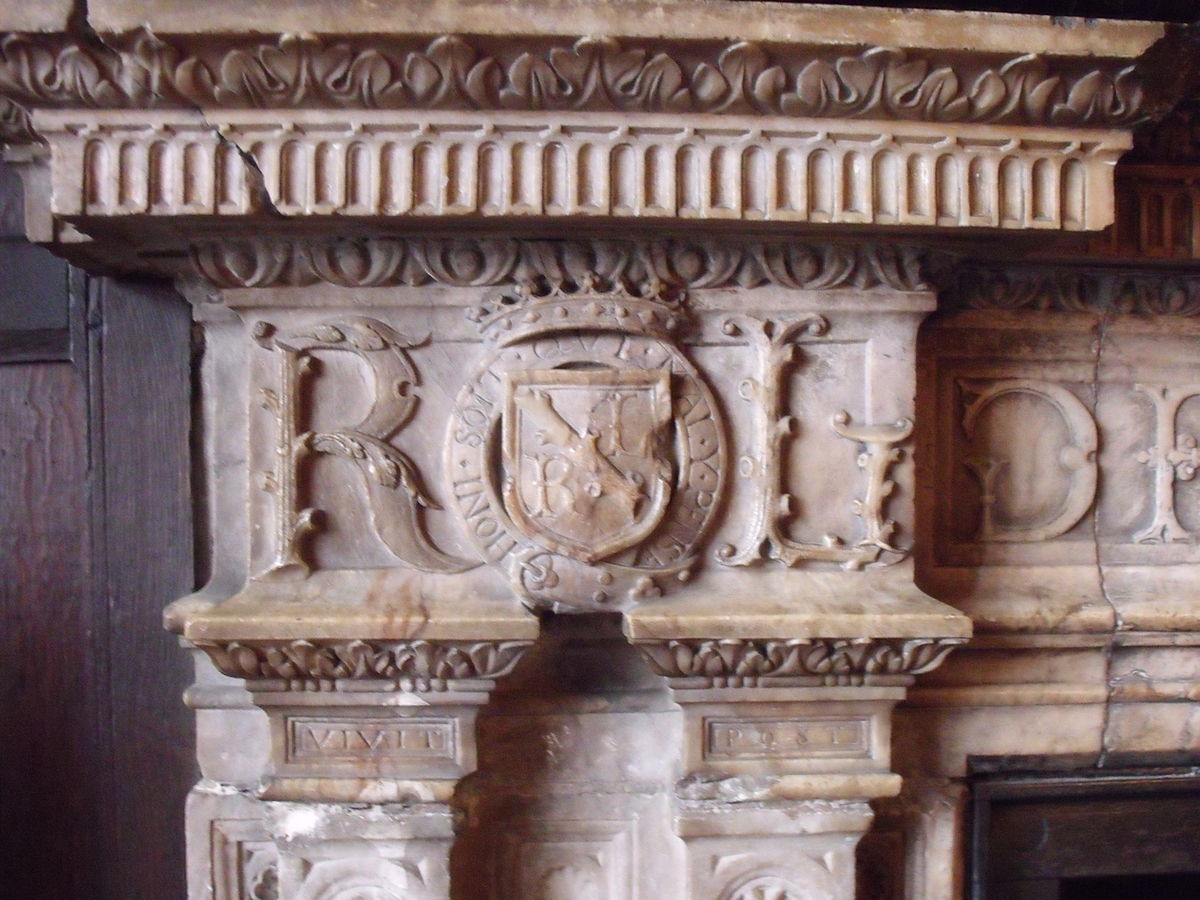
The southern room is approached through the wooden screen shown on the photo in the gallery above.  This room contains an alabaster fireplace and Elizabethan panelling that were relocated here from Leicester’s Building some time after 1650. The fireplace bears the initials ‘RL’ and the date 1571.

This photo from Wikipedia gives a close-up of the initials of Robert Dudley which are barely visible in my photo of the fireplace:

A marble fireplace in Leicester’s Gatehouse, Kenilworth Castle, Warwickshire, and the Ragged Staff heraldic badge used by the Earls of Warwick. Author: User miteyheroes (James Fishwick) on Flickr. Creative Commons

These are photos of the wooden stairs and first floor bedrooms:

Finally is the top/third floor of Leicester’s Gatehouse and a few photos from the information boards about Sir John Davenport Siddeley’s career and some of the vehicles produced by the Armstrong Siddeley Company over the years, which included aero engines and airframes. Sir John died in 1953 and car production ceased after 1960 but the aviation side of the business continued. I particularly like the last photo in the gallery which shows one of Siddley’s cars from 1925, with Kenilworth Castle in the background.

I set out to write a single post about Kenilworth Castle – and now there are three. I seem to have got a bit carried away but I enjoyed reminding myself about a lovely visit we had to Kenilworth in 2017 and of its amazing history. The restoration work done by English Heritage is wonderful and ongoing, and the Elizabethan Garden they created is lovely.

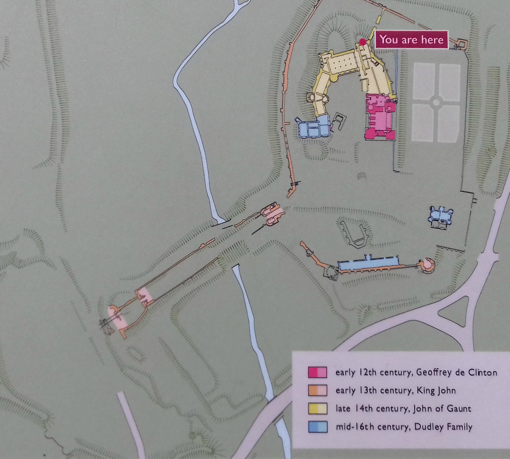
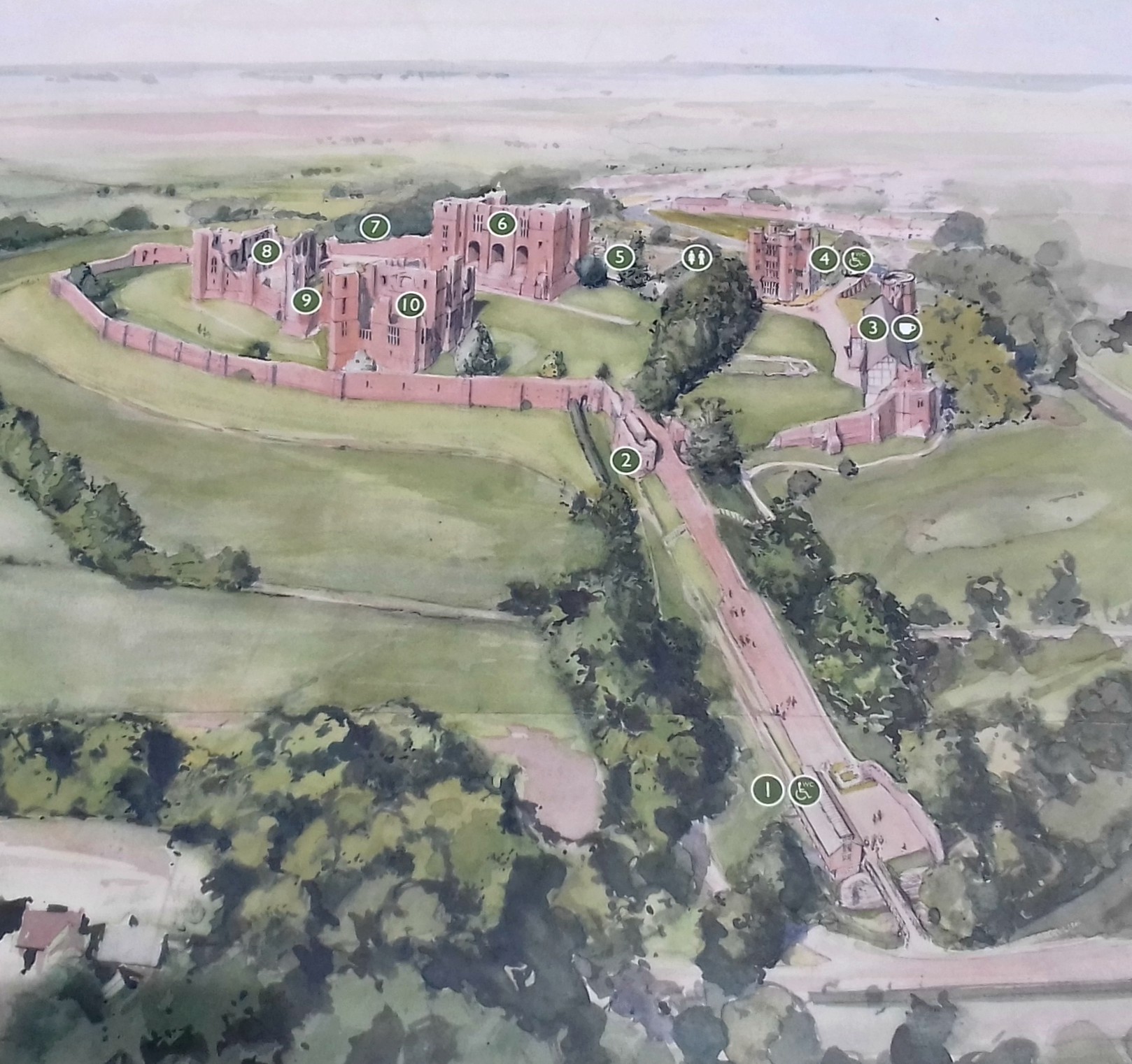
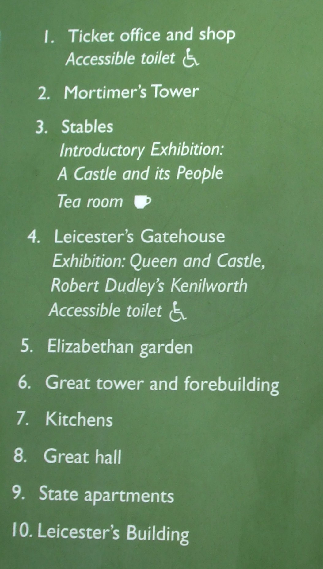
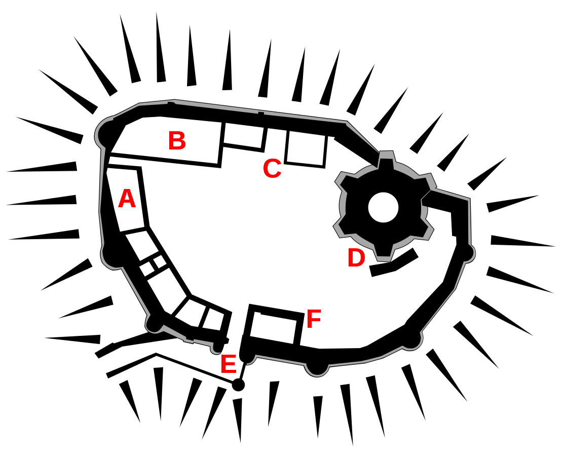
The photo below shows a plan of Kenilworth Castle as it appears today: an extremely interesting and safe environment for visitors.

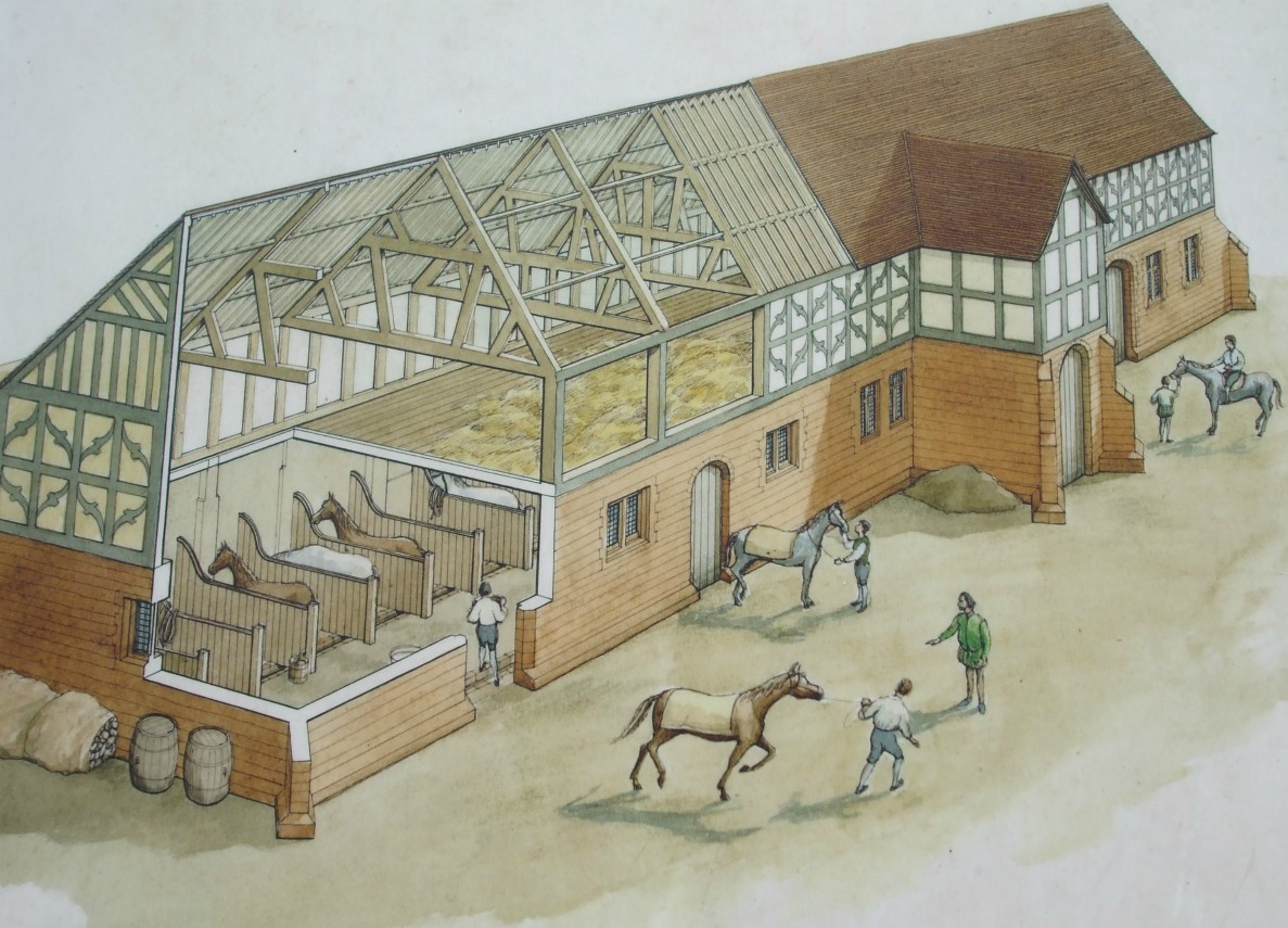
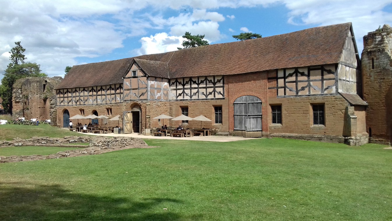
Key to map:   1. Mortimer’s Tower  2. Old Stables (Cafe and Information)  3. Leicester’s Gatehouse  4. Base Court  5. Great Tower  6. Inner Court  7. Great Hall  8. Leicester’s Building

*

References:

English Heritage Guide Book: Kenilworth Castle

Information boards around the site

Various online sites including: English Heritage website, Historic UK and Wikipedia

Kenilworth Castle: Part 2

In Part I of this post last week I took a brief look at the history of Kenilworth Castle from its origins in the 1120s to the 16th century when it was given to Robert Dudley, Earl of Leicester by Elizabeth I. In today’s post I want to bring Kenilworth’s history up its slighting in 1650 following the Civil War. To start with, here’s a reminder of the castle’s location in the county of Warwickshire…

Map created by Nilfanion using Ordnance Survey data.  Creative Commons. Annotations are my own.

… and the plan showing the various stages in the castle’s development and growth between the 12th and 16th centuries:

Before I plunge into describing the building works undertaken by Robert Dudley in the 16th century, I want to step back apace and take a look at the actual buildings added by John of Gaunt between 1373 and 1380. In the previous post, I simply mentioned that he’d transformed the fortified castle into a great palace – which is exactly what he did. His new buildings, shown in yellow on the above plan, replaced a succession of earlier ones that had stood on the site, including great halls.

John of Gaunt, the fourth son of Edward III, made certain that family and guests enjoyed comfort and luxury when residing at Kenilworth. His Great Hall was the centrepiece, flanked on the left by spectacular kitchens and the Strong Tower, and on the right by the Saintlowe Tower and State Apartments. The Great Hall was described as the architectural masterpiece of the inner court and was designed to show John of Gaunt’s regal status. This is a reconstruction illustration of what it might have looked like in its heyday:


Designed as a statement of hospitality and display, the Great Hall was where members of John of Gaunt’s family and a hundred and seventy male servants – mostly of aristocratic birth – took their meals. It had a high-pitched roof and very tall windows along the side walls, with six fireplaces. It probably had a raised minstrel’s gallery at the near end of the diagram above.

These are a few photos of the ruins of the Great Hall today. The last one shows part of the  Strong Tower to the right.

The kitchens would probably have been mostly timber framed, and have almost disappeared now, but they were twice the size of a normal aristocratic kitchen. It was a long rectangular hall, 66 feet x 28 feet, built against the earlier curtain wall, along which three  huge fireplaces are preserved. The room was top-lit, had a cobbled floor with  a drain in the centre for kitchen waste.

The diagram with the cauldron among the photos below shows a depiction of the kitchen at Windsor  Castle in the 19th century and gives a good idea of what the kitchen at Kenilworth would have looked like. The massive cauldron was used for boiling meat. The little lad in the last photo looks to be perched where an oven would have once been, with the space for the cauldron and steps up to it to his left.

The two towers and state apartment to either side of the hall are interesting to explore and views of surrounding countryside from both are excellent – some  areas of which which would have been part of the mere in John of Gaunt’s time.

I won’t show photos of the towers here, or this post will be far too long, so I’ll finish looking at John of Gaunt’s buildings by saying that his Great Hall must have been extremely impressive as it’s the only one of his buildings that was left unaltered by Robert Dudley 200 years later.

In the previous post, I got as far as describing the changes Henry VIII made to the castle and how, in 1363,  his daughter Elizabeth I, had given it to her favourite, Robert Dudley, Earl of  Leicester. The Stables -now the Cafe and Information Centre, which are also shown in Part 1 – already stood in the Base Court, having been built on the orders of Robert’s father, John Dudley, in the early 1500s.

So after that brief step back in time, I’ll continue with the changes made to Kenilworth by Robert Dudley himself. As shown in the plan above, Dudley’s building works are shown in blue, including his father’s stables. Dudley – or Leicester as he is often called – constructed two fabulous buildings around 1571-2, known as Leicester’s Gatehouse and Leicester’s Building. He also made changes to various other buildings, including the Great Tower/Keep and created the colourful new Elizabethan Gardens.

This photo shows three new, large Tudor-style windows added to the Great Tower to replace the small 12th century ones:

One of his main reasons for such elaborate works was to create a castle fit to receive  Elizabeth I and her entourage in suitable style. The Gatehouse was intended to provide an imposing first view of the castle from the Coventry Road and his magnificent new lodgings, i.e. Leicester’s Building, were simply to impress Elizabeth and provide for her comfort.

Leicester’s Gatehouse straddled the medieval curtain wall and featured an entrance passage at ground level wide enough for carriages to pass through, with two floors of lodgings above. The corner turrets were originally battlemented, a symbolic rather than a defensive structure, as was common with Tudor buildings.

Similarly, the passage was not defended in any way other than by a pair of gates and on both facades there are extensive windows. In 1650, at the end of the Civil War, Leicester’s Gatehouse was a part of the castle that wasn’t slighted and was converted into a private house by Colonel Joseph Hawkesworth, the Parliamentarian who had overseen the castle’s slighting. It remained a private residence for the next 300 years, lived in by a succession of gentlemen farmers. Most rooms in the Gatehouse today are furnished to reflect the style of the 1930s when it was last lived in – which I’ll look at in the third and final part of this  post.

Leicester’s Building was, unfortunately, badly damaged/slighted following the Civil War, but in its day it was an elaborate structure, the size of a compact country house, and it extended beyond the curtain wall. It was four storeys high, but because it’s on the slope of the hill and out over the former ditch, the ground floor and basement were below the principal floor level.

Leicester’s Building was designed to mirror the 12th century Great Tower and Leicester was determined it would equal the old tower in magnificence. He ordered an upper floor to be added to make them similar in height. The ground floor consisted of bed chambers for the queen’s ladies-in-waiting and on the first floor was Elizabeth’s own bed chamber plus outer and inner rooms in which she might meet with her advisors. It is thought that the top floor was a long gallery, where Elizabeth could walk or rest and was possibly used as a dancing gallery. It had huge windows with wonderful views of the surrounding countryside. The first of the two diagrams below shows what the second and third floors might have looked like and the second one gives a closer look at the queen’s bed chamber with her bed against a lost partition wall:

These are a few photos taken at various places around the ruin of Leicester’s Building, many showing views of the surrounding countryside or of other parts of the castle:

Many of Leicester’s new and updated buildings were ready for Queen Elizabeth’s visit in 1572. By the time of her last visit in 1575, Leicester had also created a fashionable Privy Garden to the north of the Keep. It was rumoured that during Elizabeth’s final and lengthy nineteen-day visit (July 9-27) he made his last attempt to win her hand. It was a sumptuous affair that ‘took pageantry to its limits’ with no expense spared on feasts and staged mock battles, plays and other performances, tilting, bear-baiting, ceremonial gunfire, water fetes and, of course, dancing. This famous painting from around 1580 reputedly shows Queen Elizabeth dancing La Volta with Lord Leicester at Kenilworth:

It is well known that in the early days of her reign, Elizabeth was strongly attracted to Robert Dudley and he to her. But the death of his wife, Amy Robsart, in suspicious circumstances in 1560, cooled the affair. (Amy was found at the botttom of a short flight of stairs at Cunnor Place in Oxfordshire with a broken neck and two wounds on her head. Suspicion fell on Dudley, not surprisingly due to his infatuation with Elizabeth – and his desire for more power was well known.) 

To finish with, here are a few photos of the (recreated*) Elizabethan Garden / Queen’s Privy Garden that Dudley had created. It was situated on the northern side of the Great Tower with a raised terrace running across the bottom of the building. It is divided into four quarters, each with an obelisk in the middle and colourful and fragrant with herbs and flowers with grassy pathways between. A fountain of white, Tuscany marble stands in the centre of the garden. It depicts two ‘Athlants’ i.e. Atlantis figures, joined together and holding up the sky. The ‘boll’ discharges jets of water. There are also arbours and an aviary. 

* The Elizabethan Garden we see today was recreated by English Heritage in 2009 from an eyewitness account written by Robert Langham, a minor official, in a letter to a friend. 

…and this is a photo showing what Kenilworth Castle might have looked like around 1575-80 after all Leicester’s work, including the Elizabethan Garden:

*

References are listed on Part 1 of this post.

Kenilworth Castle: Part 1

Kenilworth Castle is one of two fabulous castles in Warwickshire we’ve visited several times – the other being Warwick Castle. Although Kenilworth’s fortifications were dismantled (slighted) by parliamentary forces at the end of the Civil War of 1642-49, it is still one of England’s most spectacular castles and is located in the town of Kenilworth in the county of Warwickshire, UK.

The location of Kenilworth Castle within Warwickshire, UK. Base map of Warwickshire from Nilfanion at Wikipedia.

It is thought that a castle has stood at Kenilworth since Saxon times, though the original structure was destroyed during the wars between the Saxon King Edmund and Cnut/Canute, King of the Danes (who ruled England 1018–1035). Following the Norman Conquest in 1066, Kenilworth became the property of the crown and was a royal residence from the 12th to the 17th century.  During that time it was owned by a succession of well-known historical figures. Each of these played a part in increasing the size and changing the shape of the castle as well as improving its defences and value as a residential home. Unfortunately, the Civil War of 1642-49 put an end to further growth – although it was by no means totally abandoned.

The following plan of Kenilworth Castle was on an information board near to the Entrance and Ticket Office (above). It shows the castle as it stands today. The key to the numbers is beneath it:

From the ticket office and shop, the castle is approached along the Tiltyard Dam, the long path up to the ruins of Mortimer’s Tower, as shown on the plan above. Once inside the Outer Curtain Wall, to the  right can be seen the former Stables, now the Cafe and Exhibition Centre, an important place for all visitors when in need of a drink and/or a snack, or a lunchtime meal, especially if you intend to stay for the day, as when events are held. It is also a good idea to view the introductory exhibition set up inside before heading off to investigate the various parts of the castle.

Kenilworth is a wonderful castle, constructed from local red sandstone and the result of almost five hundred years of continuous development and expansion. The years following its slighting in 1650 saw some restoration and, unfortunately, also some years of neglect.  The plan below shows the stages of development and growth over those first 500 years:

The first part of the castle to be built is shown in red/pink – the Great Tower or Keep.

Following the Norman Conquest, the Kenilworth Estate became the property of the Crown. In 1129, King Henry I gave it to his  chamberlain, a Norman noble named Geoffrey de Clinton, who was Treasurer and Chief Justice of England at the time. The new Norman castle  was built on a low sandstone hill at the crossroads of two ancient trackways. De Clinton built most of the Great Tower/Keep (shown below) and also founded Kenilworth Priory nearby.

The following illustration shows the extent of the early castle, built around the Norman Great Tower started by de Clinton in the 1120s and finished by Henry II in the 1170s.

Around 1210-15, the castle was significantly enlarged by King John, who inherited it from his father, Henry II. John spent enormous sums of money in transforming it into a powerful fortress with two concentric walls. The outer curtain wall had defensive towers at intervals and at the entrance were two stout towers, together called Mortimer’s Tower (a peachy colour in the plan):

King John also surrounded the castle by huge water defences, created by damming local streams. The economic benefits of the mere/lake came in the ready supplies of fish and waterfowl for the castle kitchens, and it also afforded scenic and recreational benefits. But the resulting level of defence provided by the building works and mere together was exceptional, and sufficient to withstand assault by land and water. This was proven in 1266 during the reign of King John’s son, Henry III:

In 1264, Simon de Montfort, Earl of Leicester, led the barons in revolt against Henry III’s tyrannical rule. They seized Kenilworth Castle and laid siege for six months – the longest siege in English medieval history. It ended when disease and famine forced the barons to surrender. It is thought likely that it was de Montfort who had the defensive outwork known as The Brays constructed (far left in the illustration) some time before 1265.

The flat surface of the dam built to hold back the mere is likely to have have been used as a tiltyard – a place where jousting tournaments took place – as far back as the 13th century. Edward I attended such an event in 1279, along with 100 knights and their ladies. In the late 16th century, during Elizabeth I’s reign, the dam at Kenilworth was walled both sides in stone and specifically called a tiltyard. By then, tournaments could be viewed from the Gallery Tower, which stood near to where the ticket office is today. The last jousting tournaments in England were held a year before the death of James I in 1624

The next major changes to Kenilworth came in 1362 when the dukedom of Lancaster passed to John of Gaunt, the fourth son of Edward III. In the 1370s, John of Gaunt began to transform the castle into a magnificent royal palace, building the Great Hall and lavish apartments – as shown in this rather shadowy photo of the reconstruction diagram. It also shows the Collegiate Chapel, a private chapel close to the outer curtain wall, built between 1314-22 during the reign of his grandfather, Edward II, and probably demolished around 1524.

The Lancastrian king, Henry V (reign 1413-22) even built a retreat called the ‘Pleasance in the Marsh’ in celebration of his famous victory at Agincourt. The Pleasance was a luxurious, moated residence at the far north-western side of the lake, hidden from the castle by a spur. As the name Pleasance suggests, the mansion was for pleasure and relaxation. According to a castle surveyor of 1563, ‘kings would  go in a boat out of the castle to banquet there’. Henry VII also visited the castle often with his queen, and in the 149os he had a tennis court built.

But in 1524 Henry VIII ordered the Pleasance and its surrounding structures and gardens to be taken down. Henry VIII not only removed the Pleasance; during the years of his Dissolution of the Monasteries (1536-39) the priory built by Geoffrey de Clinton was pulled down. By this time the priory had become a flourishing abbey, and evidently, Henry decided it had to go!

However, Henry VIII loved Kenilworth Castle as a place of leisure and retreat as much as his father had done, being particularly drawn to the fine hunting in the well-stocked park. He spent £460 on building works around the castle – a huge sum of money in those days – notably on a range of timber-framed lodgings for family and guests between the keep and John of Gaunt’s  state apartments. He also had a timber-framed building set up in the outer court, probably using materials from the dismantled Pleasance in the Marsh. It can be seen in the reconstruction illustration below, which shows the extent of the castle by about 1540.

In 1563, Queen Elizabeth granted Kenilworth Castle to Lord Robert Dudley, her favourite. The following year she made him Earl of Leicester and Baron of Denbighshire. For a short time in the early 1550s, Leicester’s father, John Dudley, Earl of Warwick and Duke of Northumberland, had held the castle. He made a few new additions, including the building of the impressive Stable, which stands along the outer curtain wall and is used today as a cafe.

A cut away reconstruction showing the possible arrangement of the stables in the 16th century.

The ground floor contained boxes for 30 horses and 20 geldings, while the floor above was a storage place for straw and hay and possibly accommodation for the grooms. Nowadays, only a single storey, the great ceiling can be seen. It was restored in the 1970s.

In the foreground of the stables today are the foundations of the Collegiate Chapel mentioned earlier in connection to John of Gaunt. It was possibly demolished around the same time as the Pleasance and the materials of both used in Henry in VIII’s  new timber-framed building that was later removed by Leicester.

Robert Dudley made many changes/improvements to the castle, including the erection of two brand new buildings. In Part 2 of this post, I’ll finish off the story of Kenilworth Castle, starting with Robert Dudley, Earl of Leicester – and how his relationship with Queen Elizabeth will always be linked with this castle. Elizabeth and Dudley are shown below:

***

References:
Guide Book purchased at Kenilworth Castle
Various information boards around the site
English Heritage
Historic UK
Base map for location of Kenilworth Castle from Wikipedia .My own annotations.

A Couple of Lovely Victorian Parks

Southport in Merseyside is an Irish Sea coastal resort about twenty miles north of the city and port of Liverpool. It’s the town in which I was born and where I lived until I was twenty-one when I moved away to take up my first teaching post near Doncaster.

Location of Southport in Merseyside

The town grew rapidly in the mid-nineteenth century, soon becoming popular as a seaside resort known for its extensive coastal dunes and invigorating sea air. I intend to do a full post about Southport soon but, for now, I just want to focus on two lovely, Victorian parks in the town that draw many visitors every year, namely Hesketh Park and Botanic Gardens.

Locations of Hesketh Park and Botanic Gardens in SouthportHesketh Park is located at the northern end of Lord Street, Southport’s most famous street, and just a mile away from the town centre. It was created in 1868 by Edward Kemp on land donated by the Reverend Charles Hesketh of Meols Hall, which I’ll be talking about in my post on Southport in general.

These are some photos of features inside some of the entrances to the park.

This is of a photo of a fountain at the south entrance to the park. It was taken in early November 2019.

Like Botanic, Hesketh has many Victorian features and landscape designs. The central feature of both parks is a lake, around which all of the other attractions are situated. Both parks have undergone alterations and refurbishments in relatively recent years  to restore the splendour of the original Victorian work. Amongst other things, Hesketh boasts an observatory, a small cafe, a play area for kiddies, crazy golf, a small waterfall, a floral clock and a Victorian gate house at two of the four entrances, both lived in by park keepers. There are nature trails, exercise machines in some of the little niches and a large conservatory, once full of exotic plants. In 2007 the plants were removed and the building was restored on the same site. The beautiful lake has a small island in its centre for wild birds that breed in the park.

The following are photos taken in Hesketh Park on a few of our visits at different times of year. First are a few from a visit in August 2015:

These are some photos taken in Hesketh in November 2019. I always loved this park in autumn.

Botanic Gardens is in Churchtown, once a delightfully pretty village in its own right, which is now a suburb of Southport. Botanic is situated on the opposite side of Bankfield Lane to Meols Hall and its estate, the main entrance to which is shown in this photo:

Botanic was founded in 1874 by a group of working men known as the Southport and Churchtown Botanic Gardens Company, who acquired the land from the Reverend Charles Hesketh at Meols Hall – the same person who had donated land for the creation of Hesketh Park a few years earlier. As at Hesketh, the lake is the central feature. It was formed from a stream called the Otter Pool that flowed through it from Meols Hall. The lake is now known as the Serpentine and is crossed by two ornamental cast-iron bridges. At the south end of the lake was a boathouse and when I was a child we could hire little boats and row ourselves around the winding lake.

There are a number of attractions just inside the main entrance gates to greet visitors on arrival, including a former museum and cafe. These three photos  are from February 2o17:

Unfortunately, the museum (central photo above) closed in 2011, and I believe some of its exhibits are now in the Atkinson Art Gallery and  Museum on Lord Street in Southport, including this fabulous dugout canoe, dating from AD535. It was found in a field near Crossens (just north of Churchtown) in 1899, close to what once was the northern shore  of Martin Mere (‘mere’ being the name for a lake). I remember seeing this canoe many times on my visits to Botanic  in earlier years.

Dugout canoe dated AD535. Author: Small town hero: Public Domain

I also recall rooms full of stuffed animals and birds which, as a child, I hated. I still hate the idea of taxidermy, though I suppose it takes some skill, and it was extremely popular in Victorian times. Like the canoe and other local exhibits, the taxidermy section is now housed in the Atkinson Museum.

On the opposite side of the entrance to the museum and cafe is the aviary, which always delights the children. There are various bird species including peacocks (not averse to fanning their tails to impress appreciative audiences) parrots and budgerigars, to name but a few. There are also a couple of ‘runs’ with rabbits and guinea pigs. We’ve taken lots of photos of these in the past but, unfortunately, right now I’m at a loss to find them! Duh…

These are a few of the photos taken in  August 2015 and 2016. We visited in the rain in 2016. The different floral displays of each year are also evident:

Other attractions of Botanic include a bowling green, mini-golf, a children’s playground and brass bands in the summer.  A fernery houses a unique collection of ferns from around the world and is all that remains on a former huge glass conservatory that was built in Victorian times and eventually demolished in the 1930s and 40s. This is a photo of it from Wikipedia, which shows two Edwardian ladies in front of it.

Southport Botanic Glasshouse, taken during the 1920s. Author unknown. Public Domain.

It stood where some of the flower beds are today, with the front entrance facing the museum. In the  photo below, the fernery is at the back of the flower bed:


To finish with, these are a few  photos taken in Botanic in February 2017. There are no bright flower beds at this time of year and there are fewer people about, but it’s still a very pleasant place to walk, especially when the first hints of spring are evident.

The Great Orme Copper Mines

The Bronze Age Copper Mines located in Llandudno on the Great Orme headland are one of Britain’s most important archaeological sites. Excavation began in 1987 and since then over 5 miles of tunnels dated between 1860BC and 600BC have been surveyed. The mine was opened to the public in 1991, enabling visitors to see the great complex of tunnels and old surface workings. We have visited three times now, the last time being in 2017, so I thought it was about time I wrote a post about it.

Great Orme Location Map

The Great Orme headland, or peninsula, is a massive chunk of limestone, rising to 207 metres /679 feet out of the sea. Its name, Great Orme, is of old Scandinavian origin, Ormr meaning serpent and hofuth meaning head. So the headland was called Serpent’s head, and it isn’t hard to see why.

Llandudno_&_Great_Orme anotated
1024px-Conwy_UK_location_map
It is possible that the site of the mine was already a special place before anyone realised that the green copper ore could be turned into metal. It is thought that the 5,500-year-old Neolithic/Stone Age burial chamber only 100 metres from the mine was constructed there because the area was a closed, dry valley in which water disappeared down a sink hole.

Entrance to the mines is through Reception with a friendly piece of advice about wearing suitable shoes:

Entrance to the Great Orme Mines

Notice at the entrance to the site

The first part of our visit was around the large area of surface/opencast mining, which was all buried underground until excavations began in 1987.  The first opencast mining started approximately 4,000 years ago in places where the green malachite ore was visible at the surface. The malachite would probably also have been useful to the people for its colour as a pigment, perhaps for paint or eye make-up.

Open Cast Mining 2
Artist’s impression of the opencast workings as they may have appeared

Opencast mining probably continued for around 200 years, during which hundreds of tonnes of ore was extracted. When surface deposits were exhausted miners had no other choice than to follow the tunnels below ground. The little Bronze Age man on some of the photos was our guide through the mine, keeping us updated with interesting snippets of information.

The route through the tunnels for visitors has been carefully excavated since 1990. It reveals openings to previously unknown areas of the mine – many of which are too small to walk through.

Information poster at the entrance to the underground mines

Carbon dating in the Great Cavern in the central section of the mine suggests that it was mined in the middle of the Bronze Age, 3,500 years ago. It would have produced an enormous tonnage of copper metal. It is a huge cavern and so dark that it is illuminated by bright lights further in.

Early Bronze Age miners would have had a number of tools available to them. Around 3000 stone hammers have been unearthed since 1987. These were made from some of the hardest rocks, like dolorite, diorite and basalt, most lumps of which would have been found washed up on the beach. Battered markings on the hammers give evidence to the fact that the rock being worked was also fairly hard. When it was too hard to be worked with tools, a process called fire-setting was used. A fire was lit against hard areas of rock, causing it to crack. As with the use of animal fat lamps in the tunnels, fire-setting was hazardous as it burnt valuable oxygen.

Later in the period, tools were made of bronze:

Over 35,000 animal bones have been found at the mine, including cows, sheep, pigs, deer, dogs and rodents. Some of them would have been used for food, others by the earlier miners as chisels and scrapers in the mines.

The only Bronze Age smelting site in Britain was on the Great Orme.  As shown in the images below, copper ore was first broken into small fragments with stone hammers  before being fed into the kiln fuelled by charcoal, which burns at a much higher temperature than wood. The ore was changed into metal by heating it at temperatures around 1,100 degrees centigrade – which they wouldn’t have been able to measure, so I imagine they would simply get the furnace as hot as they could. The process is called smelting. Miners soon realised that on its own, copper ore is soft, and that by mixing it with 10% of tin they could produce the harder metal, bronze. The molten metal was poured into moulds and used to create a variety of objects.

As well as tools and weapons of all types, including spears, daggers, swords and shields, bronze could be made into many things, such as cups, cauldrons and the items named in to image below:

The many uses of bronze

This next image shows how broken or damaged metal implements were re-melted and re-cast into new ones:

There is plenty of evidence to show that an extensive trade network was in place during the Bronze Age.  The nearest source of tin needed to make Bronze on the Great Orme was Cornwall, 300 miles away. During the mid Bronze Age (3,500 years ago) a distinctive type of axe was made in North Wales. Hoards of these axes have been found in France and it is believed that the Great Orme copper was the main source of metal used. The metal has also been found in artefacts across Europe, stretching from Brittany to the Baltic.

Bronze Age boats found in Britain  suggest that trade was conducted by sea. The boats were capable of carrying cargoes of up to 2 tonnes and would have been able to cross the English Channel to France or Holland.

Bronze Age Travel
The mines on the Great Orme would have brought wealth and power to those who controlled them and the people of the Great Orme flourished with them.

Copper mines brought wealth and power to those who controlled them

Bronze Age copper mining on the Great Orme finally stopped when they reached the water table, by which time iron was the new material and the demand for copper declined. After a very long lull in interest, during which the mine seems to have been almost forgotten, there was a renewal during the Industrial Revolution in the 18th and 19th centuries. Water was pumped out and shafts were sunk down to 470 feet (sea level). But eventually, Llandudno became known more as a popular Victorian seaside town than a mining town. The mines were covered over by spoil at the end of the 19th century and once again forgotten.

Although a great deal of excavation has already taken place since 1987, archaeological work will continue on both the surface and underground workings for decades. Tens of thousands of mine waste still cover large areas of the early mine workings and who knows what else will be discovered about this amazing site.

Visitor Centre
The Visitor Centre provides plenty of information about the site, including a short introductory film, a model Bronze Age village, rock and ore specimens area and colourful posters around the walls to explain all about Bronze Age life on the Great Orme and working in the copper mines. The latter were the source of the snippets I’ve used in this post.

This year (2020) the copper mines re-opened on July 25, working to guidelines from the Welsh Government, including social distancing, a one-way system and face masks when viewing underground. Entry fees are £8 for adults, £5 for children and under 5s free. In 2005 the Great Orme mines was awarded the title of ‘The Largest Prehistoric Copper Mines in the World’ by the Guinness World Records Team and I can say that it’s well worth a visit.

References:

The Great Orme Bronze Age Mines Guide Book, purchased at the site

Information boards in the visitor centre and around the site

The Great Orme Copper Mines, Llandudno, Wales – Historic UK

Base map of Conwy, North Wales from Nilfanion at Wikipedia

Aerial photo of Llandudno and the Great Orme from Harvey Milligan at Wikipedia


A Visit to Conisbrough Castle

As with many of my recent posts about interesting places we’ve visited, our trip to Conisbrough was last year. It was my second visit to the site, the previous one being in 1969, when the castle wasn’t managed the way it is today. Being a local-born lad, my husband had been many times as a child and teen in the 50s and early 60s, but was happy to go and see what changes had been made now that it was managed by English Heritage.

English Heritage flag atop the keep 3

Conisbrough Castle is located on the north-eastern edge of the town of Conisbrough in South Yorkshire, UK. It is  approximately 6 miles south-west of Doncaster and 7 miles north-east of Rotherham:

Location of Conisbrough Castle in South Yorkshire
Base map of South Yorkshire, UK from Wikipedia. Source: Ordnance Survey OpenData. Author: Nilfanion. Creative Commons

The name Conisbrough comes from the Anglo-Saxon word Cyningesburh, which means ‘the king’s borough’. Although Conisbrough was already an important town before 1066, little is known about the actual site of the castle before that time. In 1066 the ‘Honour’ (or Lordship) of Conisbrough was given to William Warenne, a trusted supporter of William 1 – also known as William the Conqueror.  Warenne acquired land over thirteen counties  and became known as the Earl of Surrey.

349px-Coa_England_Family_Warren_of_Surrey.svg
Coat of arms of the Warenne Earls of Surrey. Author: Madboy 74  Creative Commons

It was probably Warenne who built the first fortress at Conisbrough, which is thought to have comprised an earthwork enclosure with a wooden palisade along the top, with timber buildings inside. There could also have been an outer bailey. It occupied a strategic position on a large knoll (hill) along a ridge of magnesian limestone.

On the death of the third earl in 1147, having no sons as heirs, the castle passed to his daughter, Isabel de Warenne, William Warenne’s great granddaughter. The stone castle, the ruins of which we see today, was built by her husband, Hamelin Plantagenet, the legitimate half-brother of Henry II.

Aerial_view_of_Conisbrough_Castle_-_geograph.org.uk_-_639358
Aerial view of Conisbrough Castle in 2007 geograh.org.uk  Author :Richard Bird Creative Commons

The stone castle consisted of an outer and inner bailey.

The outer bailey would have protected the inner bailey and contained structures needed for the management of the castle and the supply of those living there. Domestic buildings included quarters for servants, maids and farmworkers, workshops, stables and and other livestock stalls, and storage areas like barns and sheds. The barbican shown on the diagram below (which is from an information board at the site) wasn’t added until the middle of the 13th century:

Bird's eye view of the 15th century castle+

The inner bailey would have contained a number of domestic buildings behind a stone curtain wall. At Conisbrough these included:  A: solar block B: great hall C: kitchens and pantry D: keep and stairs  E: barbican and gatehouse F: chapel – as shown on the diagram below:

Plan_of_Conisbrough_Castle,_early_13th_century.svg
The inner bailey at Conisbrough Castle, early 13th century.  Author:User.Hchsc2009. Creative Commons

Today, only the foundations of these buildings can be seen.

The inner bailey with its magnificent great tower/keep is reached by crossing the outer bailey from the visitor centre to what remains of the barbican (a fortified entrance) and gatehouse through the inner curtain wall.

Approaching the barbican through the outer bailey

Built around 1210, the inner curtain wall would have provided effective defence against attackers, especially once the barbican was constructed. The wall would originally have been topped with battlements, from which lookouts and archers ensured that no attackers sneaked up unseen. Five small, solid towers were positioned on the wall’s exterior on the east, south and western sides. To the north the steep drop provided ample defence. The wall itself was not as well built as the keep, consisting of roughly dressed coarse stone with a rubble core.

The outside of the inner bailey wall

These are a few photos of the inner bailey, showing more of the crumbling curtain wall and the remnants of some of the buildings listed above:

The great tower was  built of high-quality, local magnesian limestone and is one of the best examples of an ashar-faced structure in the UK. (Ashar facing means sawed or dressed square stone used in facing masonry walls.) The tower is over 78 feet high with a circular core and flanked by six wedge-shaped buttresses of 90 feet in height that extend beyond the rooftop.

Conisbrough Keep 1
Inside the tower are five levels (the rooftop being the fifth). This rather unclear photo of a diagram at the castle may give some idea of that:

Plan of keep +

The lowest level is the ground floor or basement, with a well used to bring water into the rest of the building. The basement has no windows or doors and is accessed only via a ladder through the hole in its vaulted ceiling. It was probably used for storage.

The entrance to the tower is on the first floor, twenty feet above the court, and was originally reached by an exposed external timber staircase with a timber drawbridge leading into the tower that could be dismantled for defence. Nowadays a concrete staircase has been erected.

Stone steps up th keep entrance
This first floor had no natural light and, like the basement, was probably used for storage. These photos show the well cover and modern safety grid and railing:

A wide, well-lit stone staircase takes us up to the great chamber on the second floor:

Steep stone steps in the keep

The room would have been used by the de Warenne lords when they were staying in Conisbrough. It looks cold and bare today, but it would once have contained a number of fine objects and silverware, painted furniture, beds with feather mattresses with colourful rugs on the floor and tapestries on the walls to keep out the cold. A long trestle would have been used for meals, feasts and banquets and so on.  A wide fireplace, with a joggled lintel and possibly a colourful hood, would have thrown heat into the room. A door leads into a latrine and there is an alcove with a window overlooking the entrance to the tower:

The stairs leading to the third floor are narrower than the lower ones. This floor consists of the bedchamber, where the lord and his family could rest and sleep. It would have been beautifully decorated and have a comfortable bed, cushions, a large basin for washing and a latrine. A window alcove faced towards the town, with stone benches that would have been cushioned so people cut sit and rest or chat. A fireplace provided heat. It was the Lady de Warenne who told us all about this room:


A chapel within one of the buttresses on the east of the tower opened from the bedchamber. The de Warenne family would have attended Mass here in private, and the priest, who would have lived at the castle, would pray for their souls. The chapel’s most noticeable feature was the beautiful vaulted ceiling. The two wash basins (piscinas) are on opposite walls – which is unusual, as in most chapels from the 12th century onward the two were side-by-side.

The rooftop forms the fifth floor. Originally it looked quite different to how it looks today. It is thought that at some time there was a room surrounded by an enclosed wall passage, as part of the wall and a door jamb survive. Of the six buttresses that extended above the battlements as turrets, two of them were solid. The other four seem to have functioned as two water tanks, a bread oven and a dovecote.

Rooftop buttresse 1
Views of the surrounding countryside are excellent from the rooftop, especially as the castle is on hill on an already raised ridge. These are a few of the photos we took:

Conisbrough Castle has had an interesting history over the centuries and had a variety of owners. I won’t go into detail here, but a short word will be useful to bring the castle up to the 21st century.

After the death of the last Earl Warenne in 1347, the castle reverted to the Crown.  Edward III settled the Warenne northern estates on his fourth son, Edmund Langley, who later became the Duke of York. The castle became embroiled in the Wars of the Roses (1455-85) after which it was abandoned and fell into ruin. By 1538 the keep had lost its floors and the gatehouse and part of the curtain wall had collapsed. At the end of the Civil War (1642-51) there was no need for it to be further slighted (cannoned down) by Cromwell – as so many other Royalist-held castles were – since it was already in a ruined and unusable condition.

The castle remained a popular tourist attraction until the early 20th century and in the 1950s its management was taken over by the Ministry of Works, who made a number of major repairs. But by the 1980s visitor facilities were declared unsuitable and in 1984 the castle passed into the care of English Heritage.

Together with Doncaster Metropolitan Borough Council and a local charitable trust, the great tower was re-roofed and floored to protect it from the weather and improve public access. A new exhibition centre was built. In 2007, Conisbrough Castle became totally under the management of English Heritage, which does an excellent job in the castle’s upkeep and makes it a wonderful place to visit. Some visitors come with the sole intent of seeing for themselves the place that, in 1819, Sir Walter Scott chose to set parts of his famous novel, ‘Ivanhoe’.

*

Refs:

Conisbrough Castle Guide Book (from English Heritage)

Information boards around the site

Various online sites including:

English Heritage

Conibisbrough Castle:A Comprehensive Guide of the Castle

Wikipedia

Visit Doncaster

Welcome to Yorkshire Yorkshire.com

Wikipedia

The Canal Pond and Emperor Fountain at Chatsworth

The Canal Pond is set in the South Lawn at Chatsworth and was dug in 1702-3. It is set a few inches higher than the lawn, creating the illusion that the house rises out of the water when viewed from the far end of the canal.

chatsworth-house-736070_1920
Image by Johnnie Shannon from Pixabay

There had been a fountain at the north end of the canal since the pond was completed. Originally named the Great Fountain, it is flanked by two reclining river gods, created by the sculptor Nadauld. The gods can just be seen in this photo, one of them behind a lady photographing the dog structure:

Canal pond showing 2 gods and dog structure

When it became known that Tsar Nicholas 1, Emperor of Russia, would visit Chatsworth in 1844, the Great Fountain was replaced by the Emperor Fountain. Commissioned by the 6th Duke and created by Joseph Paxton, it was so named as a welcoming gesture to the tsar. Unfortunately, Tsar Nicholas never did make that visit but the fountain kept the name anyway.

Tsar Nicholas of Russia
Portrait of Emperor Nicholas 1 by Franz Kruger (1797-1857). Housed in the Hermitage Museum in Saint Petersburg. Creative Commons/Public Domain

Although the original Great Fountain had been the highest in the country, the new Emperor Fountain exceeded its reach and is on record as having reached 90 metres/295 feet. It was powered by the pressure of water dropping 297 feet through a 16 inch cast-iron pipe. It was the tallest gravity-fed fountain in the world for 160 years.

To provide enough water to power the new fountain an 8-acre lake, aptly named Emperor Lake, was dug up in the surrounding moorland of the Peak District. (This was in addition to the three existing lakes already providing the immense volumes of water needed by the house and its surrounding grounds.) Emperor Lake was finished in only six months in 1844.

The following painting, which I used in my earlier post on Chatsworth House, gives some idea of the height of the land behind the house and grounds:

Chatsworth_from_Morris's_Seats_of_Noblemen_and_Gentlemen_(1880)
A late 18th century oil painting by William Marlow. It emphasises the romantic aspects of Chatsworth’s setting on the edge of the Peak District. Public Domain

If you look closely at the hillside, you will spot a small building. That is the hunting lodge, situated in Stand Wood on the edge of the hills and moors of the Peak District. Emperor Lake can be seen from the lodge, should visitors choose to wander up there.

A two and a half mile channel was dug across moorland to gather rain that fell on the high ground. As mentioned above, the fountain was powered by the pressure of water dropping 297 feet through a 16 inch cast-iron pipe. In places, trenches up to almost 15 feet deep were cut through the rock to maintain the gradient.

In 2014 two new nozzles were made for the fountain. One is the same diameter as the original nozzle and the other is a little narrower, the aim being to create a column of water similar to the one that Paxton achieved. With the new narrower nozzle and a new debris grid in Emperor Lake, which supplies the water, the fountain can still reach 62 metres/200 feet on a still day.

Although this may not be the most attractive fountain in the world, the height it reached so long ago and the story about Tsar Nicholas, certainly make it interesting.

***

This is the second part of a post I wrote a few weeks ago about Chatsworth House in Derbyshire. The first part was already rather long, so I thought I’d leave this short piece for another time.

A final note: Writing this has set off a discussion in our house about the spelling of tsar. I’ve always spelled it this way, but my husband argued that if should be czar. Well, after looking it up it seems there are three spellings of the word: tsar, tzar and czar. So it seems to be a case of ‘take your pick’!

Steampunk Festival 2019

024

Over the Bank Holiday weekend last year (August 23-26) the world’s biggest Steampunk festival returned to Lincoln for the 11th time. Held along the cobbled streets of the Cathedral Quarter, in the grounds of Lincoln Castle and in parts of Bishop Grosseteste University, the festival celebrates the steam powered world of the late nineteenth century and attracts people from all over the world. A number of events keep visitors entertained over the three days.

This was our first visit to the festival and we didn’t realise what a fun event we’d been missing. In fact (being from the Stone Age ourselves) we weren’t entirely certain what steampunk was all about. So for anyone else similarly uncertain, here a a few definitions:

First, from The Ministry of Peculiar Occurrences: http://www.ministryofpeculiaroccurrences.com/what-is-steampunk/

Steampunk is an inspired movement of creativity and imagination. With a backdrop of either Victorian England or America’s Wild West at hand, modern technologies are re-imagined and realized as elaborate works of art, fashion, and mechanics. If Jules Verne or H.G. Wells were writing their science fiction today, it would be considered “steampunk.”

Second is this one from: Steampunk Avenue blog: https://steampunkavenue.com/en/blog/what-is-steampunk/

Steam is a central element of steampunk. The technology featured in this universe is generally just as advanced as that of our modern world, but it uses steam as its energy source instead of electricity, gas or oil. As a result, steampunk technology takes on a retro look reminiscent of the Industrial Revolution era. As Douglas Fetherling so aptly put it, “Steampunk is a genre that imagines how different the past might have been had the future come earlier.”

We saw some interesting looking machines and vehicles in and around Lincoln Castle that day. These are just a few of them:

What about the punk in steampunk? This explanation is from the Asylum Steampunk website: https://www.asylumsteampunk.co.uk/what-is-steampunk/

Can you still call it steam-PUNK?  Punk in the seventies was a rebellion against contemporary society.  We are most definitely rebelling but we are making a stand against: throwaway society, poor manners and antisocial behaviour, homogenisation and commercialism.  We are punks who are polite, friendly, care about the environment and the past and encourage creativity.

Steampunk style decoration on a stall

The costumes are terrific and so creative, and in Lincoln – as I imagine there are in many cities and towns – there’s at least one shop that sells ready-made costumes for steampunks. Several people we chatted to had made their own costumes. With temperatures of 31-33 degrees (Celsius) it must have been unbearably hot inside some of the costumes, especially for those wearing gas masks and other weird head coverings, or items of clothing such as thick cloaks and coats, long boots or tight corsets!

We also saw this character wandering around chatting to everyone. By golly… it’s Captain Jack!

There were plenty of stalls selling steampunk clothing and other items, in both the castle grounds and around the Cathedral and the top of Steep Hill:

One of the main events of the day was the Parade, featuring a very young Queen Victoria and a variety of individuals and groups, including nurses and soldiers – even some mounted on their trusty steeds (i.e. dinosaurs). Visitors lined the road through the castle grounds to watch the procession walk there and back – and guess who we spotted amongst the spectators:

We were hoping to go again this year, but unfortunately all events are cancelled. I can only hope things are back to normal by August 2021.

Parasols out on a hot day


Chatsworth House

Chatsworth House is probably the best known of the stately homes in Derbyshire and has been voted Britain’s favourite country house several times. It is situated nine miles west of Chesterfield and three and a half miles north-east of Bakewell.

Location of Chatsworth House in Derbyshire

The house stands on the east bank of the River Derwent, looking across to the hills between the Derwent and the Wye valleys.

1197px-Chatsworth_Bridge
The river bridge and the house at Chatsworth,  Author: Rob Bendall

The magnificent yellow-stoned house, set in expansive parkland and backed by wooded, rocky hills rising to heather moorland, is the seat of the Duke and Duchess of Devonshire and has been passed down through sixteen generations of the Cavendish family.

The original Tudor House was built in 1552 after the estate was acquired in 1549 by Sir William Cavendish. Sir William died in 1557 with the house partly constructed and it was left to his formidable wife, Bess, also known as Bess of Hardwick, to complete it. Little of that original house remains today.

Elizchatsworth_edited
17th century painting of the west front of the Elizabethan Chatsworth. 1680s or earlier. Artist unknown. Pubic Domain

Mary Queen of Scots was imprisoned here at various times between 1569 and 1584, and although the rooms of her apartment have since been rebuilt, two rooms are still called the Scots Apartment.

330px-François_Clouet_-_Mary,_Queen_of_Scots_(1542-87)_-_Google_Art_Project
Mary, Queen of Scots (1542-87) painted by François Clouet (1510-72) Public Domain

After Bess’ death in 1608, Chatsworth passed to her second son, also named William. In 1618 he was created the first Earl of Devonshire and in 1694 the fourth Earl was created the first Duke of Devonshire. (For anyone who doesn’t know, a duke/duchess is higher in the ranks of nobility than an earl/countess. A duke/duchess comes after prince/princess who is second to king/queen).

Between 1686 and 1707 the first Duke rebuilt Chatsworth in Classical style and between 1720-64, the park was landscaped by the fourth Duke. The famous ‘Capability’ Brown was hired to reshape the then formal gardens to how we still see them today. The stables and the bridges over the Derwent were also added in the 18th century.

1200px-ChatsworthMarlow
A late 18th century oil painting by William Marlow. It emphasises the romantic aspects of Chatsworth’s setting on the edge of the Peak District. Public Domain

The library and north wing were added to the house by the sixth Duke between 1790 and 1858.

Chatsworth_from_Morris's_Seats_of_Noblemen_and_Gentlemen_(1880)
A view of Chatsworth from the south-west circa 1880. The stables can be seen behind the house and the Hunting Tower is visible in Stand Wood. Public Domain

On entering the house through the North Entrance, we made our way to the Painted Hall and Great Staircase. There were a lot of people in the room, but we managed a few photos during a relatively ‘quiet’ time. This is a magnificent hall, the artwork on the walls and ceiling being particularly stunning. Our photos don’t do it justice due to the glare from the many lights.

We continued along the Chapel Corridor, with lots of sculptures, paintings and other items of interest to  look at…

Chapel corridor with various sculptures and ornaments (2)

…which, unsurprisingly, took us to the Chapel. This is another fabulous room, richly ornamented with a colourful ceiling.

Next to the Chapel is the Oak Room. No prizes for guessing why it is called that:

Though it lacks the colour of many of the rooms, the Sculpture Gallery contains some really beautiful pieces.

Other rooms in which we managed to take photos include the Great Dining Room, the State Music Room,  the Library, the State Bedchamber and one of the Guest Bedroom. I’ve added a mix of these rooms to the gallery below, including a few of the many paintings on display. The images showing wallpaper are included because, as in a few other stately homes we’ve visited, many wallpapers were of a Chinese design and hand painted. I believe the imitation European versions were called Chinoiserie, and although the first were seen in Europe in the 16th century, they were particularly popular in stately homes in the 18th – 19th centuries. A dictionary definition of Chinoiserie is: a decorative style in Western art, furniture, and architecture, especially in the 18th century, characterized by the use of Chinese motifs and techniques.

Last year (2019) Chatsworth was celebrating all things ‘dog’. It was officially titled, The Dog: A celebration at Chatsworth. It explored the Cavendish family’s enduring love of dogs. Around the site are a variety of dog sculptures, paintings, drawings and photos, some from the Devonshire collection and others on loan from public and private collections. These are just a few of them:

Surrounding the house, the extensive parkland, farmyard and playground would take more that a day to fully explore and we had little time to see much of it during our visit. What we did see was impressive, but we would have loved to have got down to the Arboretum and Trout Stream. In the afternoon, we spent some time wandering around the immediate lawns and kitchen gardens. We had planned another visit this year – but I think that will now have to wait until next year.

These are some of the many photos we took around the immediate grounds and gardens:

There are plenty of places to eat at Chatsworth, and a number of talks and activities are available. Chatsworth is a place for family days out as well as for couples, singles, and anyone who loves a good dose of history or lovely scenery. Chatsworth is not a National Trust property and entry prices for both house and grounds are not cheap and can be as much as £17.50 per adult for last minute bookings – as was ours. However, many local families come to just enjoy and picnic in the grounds, which is considerably cheaper. All I can say is that Chatsworth is a truly fabulous place and, at very least, well worth a visit. This amazing fountain has a history all of its own. But I’ll leave that for another post.

Canal Pond and Great Fountain 2

The Deep

mangrove swamp
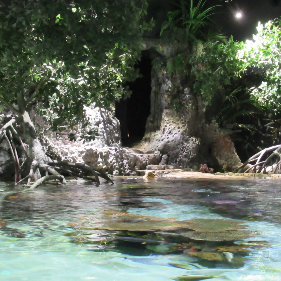
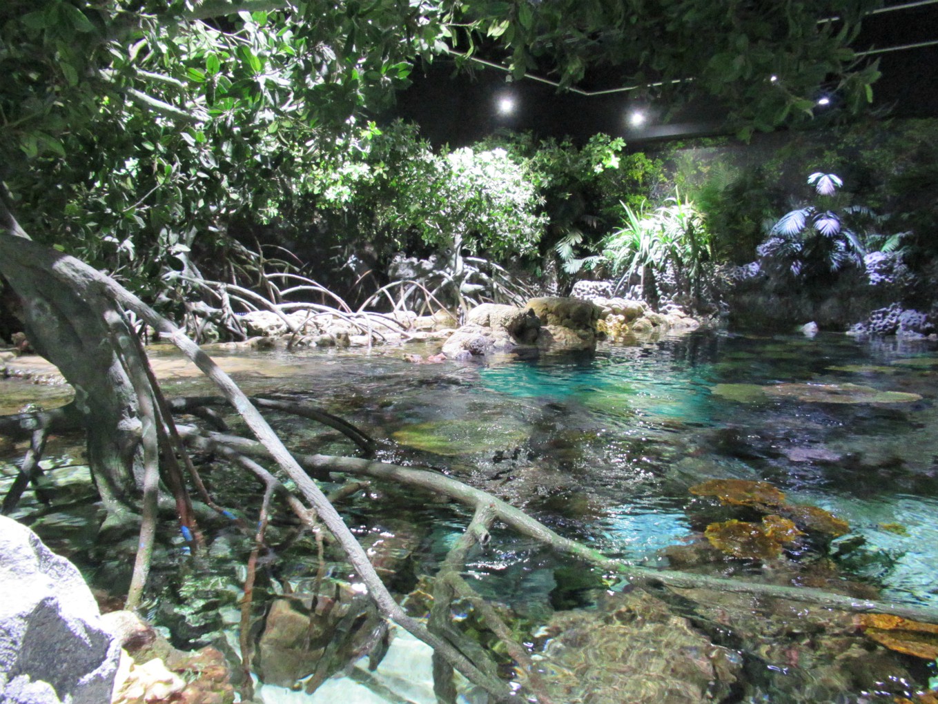
The Deep is a public aquarium in the city of Kingston-upon-Hull (often referred to simply as Hull) in East Yorkshire, and it’s a great place for a family day out.

Location of The Deep in Hull
Base map of East Yorkshire courtesy of Wikipedia

The building was designed by world class architects, Sir Terry Farrell and Partners and opened in 2002. Perched right on the confluence of the River Hull and the Humber estuary, it still looks pretty modern today. It’s 5 minutes walk from Hull Marina and a short distance from the city centre.

Our visit to The Deep was on a rainy day last year and we’re very glad we went when we did, especially as we’d been considering going for some time. Unfortunately, like so many museums, parks and historic sites we like to visit, the aquarium has been closed since March this year due to Covid-19. We can only hope this wonderfully educational resource can survive financially to continue in the future.

Ocean knowledge

The journey through the aquarium begins with taking either the scenic lift or the stairs – eight flights of them – up to the third floor, where the main cafe (Castaways) is located. We chose the stairs (and my knees will  never forgive me). The ‘scenic lift’ is very very popular and queues to get in it were quite long when we were there.

The winding route down takes us through over 4 billion years of ocean history.

Looking down at the visitors 
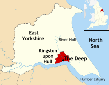
The first display is The Awakening Earth, which comprises hands-on activities and 4D screens showing creatures that would have been swimming around in the oceans up to 400 million years ago. These included Dunkleosteus (370 m years ago) Ichthyosaur (240 m years ago) and Xiphactinus (80 m years ago).

There are also living starfish to see, a species which appeared on Earth around 450 m years ago. Starfish typically have five arms but some have up to forty! Those we saw all had only five:

This freshwater creature was also around almost 400 m years ago. It is called a tiktaalik and it grew to 3m in length, had sharp teeth and looked like a cross between a fish and a crocodile. It was, however, technically a fish and it lived on a continent called Laurentia, which was around the equator and had a warm climate.

Ancient seas 2

The Lagoon of Light is a lovely display, being an open  stretch of  blue, tropical water filled with aquatic life found in a mangrove lagoon. Hundreds of colourful, tropical fish, rays and small sharks delight all visitors and are particularly popular with children.

There are information boards along the route, some specifically aimed at children, others for older visitors. They are all so useful and informative, like these about the importance of mangrove swamps:

There are also smaller tanks with living sea creatures of all types from specific environments of today, including Coral Reefs.

Coral 11

Lovely and colourful, and home to 25% of marine life on Earth, the variety of life on coral reefs is equal to that of the Amazon rainforest. It includes tiny plankton to predatory sharks  – all of which depend upon each other for survival. Worryingly, coral is very sensitive to environmental change, pollution and overfishing and the future of these fabulous reefs remains severely threatened.

The Kingdom of Ice is intended to give visitors a glimpse of  life in the polar realm and its importance to the ocean food chains, global warming, ocean acidification and so on.  The Gentoo penguins proved popular with adults and children alike and it was difficult to get close enough to the glass to take photos. We managed a few in the end.

There are so many different ocean environments as well as displays of some species in the Amazon Flooded Forest to visit. To show them all here would mean a very long post, so here are a few random photos, including a few information boards. There are tanks full of clown fish for all Nemo fans to enjoy, but the little fish must have been hiding in the anemones when we were there. Not surprisingly, another name for them is anemonefish. (The photo of the information board below is rather blurred, unfortunately.) At feeding times, the hiding clown fish readily emerge from amongst the stinging tentacles.

The main tank, called The Endless Ocean, fills the centre of the building, extending from the ground floor to the top, and can be viewed through large ‘windows’ on several levels, including an underwater viewing tunnel. The tank is filled with 550,000 imperial gallons of water (660,000 US) and 87 tons of salt. A variety of sharks can be seen, including White tip, Grey reef sharks and Zebra sharks, rays, and the only pair of Green sawfish in the UK. Turtles and rays swim past regularly, too. And although it wasn’t feeding time when we took these photos, we caught a glimpse of a diver in the tank, too.

The Endless Ocean can also be viewed from the Tunnel, which is 10 m below the surface. The tunnel is made is 6 inch thick acrylic and can take the weight of three elephants. It was very hard to take photos through, so the few we took aren’t very clear:

The Deep is a wonderful place for a day out, or for anyone on holiday in the East Yorkshire area. Children are fascinated by it and spend lots of time on the hands-on activities. There are cafes and picnic areas (some outside for when the weather is good). On rainy days the aquarium does get quite packed but it all adds to the fun. We had a great day there and learned a lot about the oceans and some of the hundreds of species that live in them.

Endless Oceans Viewing Window

The following quote from the ‘Welcome to Yorkshire’ website sums up the objectives of The Deep:

The Deep is an environmental and conservation charity, not run for profit, and is dedicated to increasing the knowledge and interest of the world’s oceans through its participation in vital research and conservation schemes around the world.