A Visit to a Japanese Garden

Last Friday afternoon, my blogging daughter, Louise (at thestorytellersabode) and I decided to drive out to the Japanese Garden, located at North Clifton, near Newark in Nottinghamshire. It’s a mere 6.4 miles from where I live, so it took no time at all to get there. I hadn’t visited the Garden since 2008, and Louise had never been before, so it made a nice change for a gloriously sunny day.

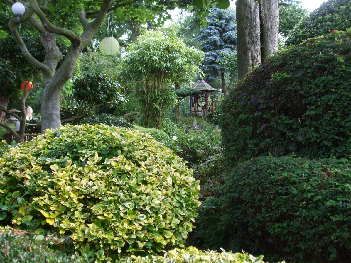
The Garden has been described as ‘One of the Inspirational Gardens of the World’ (AA) and as ‘The Best British Garden’ (ITV). It covers a relatively small area but is packed with all the traditional features of a Japanese garden. Water features and ponds with Koi carp, winding paths, bridges, moss, bamboo, pagodas and stone lanterns all blend with a sprinkling of English plants:

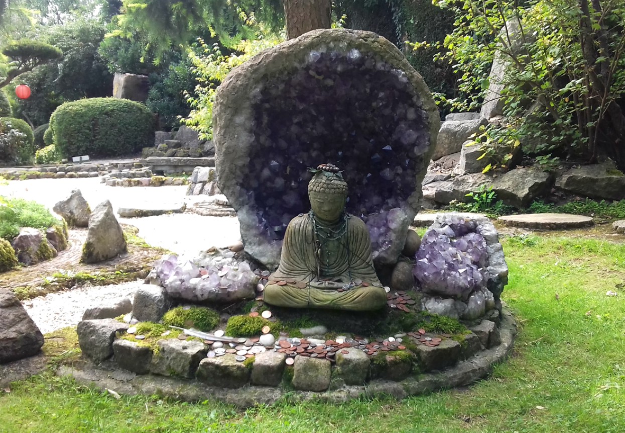
There is also a Crystal Garden – an indoor garden consisting of rocks, crystals and different marbles:

The Meditation Centre and Garden were created by a lovely man called Maitreya, who is often around the Garden. This is a summary of how it all came about from the information leaflet we were handed on entry:

Maitreya (Koji Takeuchi) was born in Handa, near Nagoya in Japan. In his teens he began a search for the truth. He was first led to Christianity but found it did not give him the direct experience of Jesus he wanted. So he turned to meditation and attended an intensive meditation course at a Zen monastery – and had the experience of ‘enlightenment’.

Aiming to become a meditation master, Maitreya went on to complete an MA degree in Buddhism and lived the life of a Zen monk for a time – a life he found too harsh and rigid, and out of date. After travelling and teaching meditation in Thailand, Nepal and India, on the invitation of a friend, he eventually came to England. After staying at various universities around the country, teaching and lecturing, he came across a property for sale in North Clifton, Nottinghamshire. This became the base from which he taught meditation: ‘Pure Land’ came into being in 1973.

In 1980, Maitreya began transforming a flat, 2 acre field – a ‘wilderness’ – into a Japanese garden. His aim was to create a peaceful area which guests to his Centre could enjoy. He had no previous gardening experience, but he set about creating small ‘hills’ in this flat place that would remind him of his mountainous homeland, Japan. The material for these came from the earth dug out to create the ponds. The large stones placed around the ponds came from a quarry in Derbyshire and the winding paths were determined by the positioning of the stones.

Refreshments are available at a Japanese Tea House, which is also where payment is made on entry ((£7 for adults). A variety of teas are offered, including Japanese and English tea and various fruit teas. (I couldn’t say whether coffee is available as Lou and I asked for tea). People can either sit inside the very small place, or outside in the garden, as we did.

An extra feature every year is that of the ‘Lantern Lit Evening Garden’, which can be enjoyed every Friday, Saturday and Sunday nights during August and September.

There are a few reviews of the Japanese Garden online but not all are favourable. It’s undoubtedly a pretty site, but it is small. The main criticism about it is the price – that £7 is too much for such a small place. Admittedly, it’s possible to walk round quickly, but most people tend to linger and spend time sitting at various nooks around the place or in the tea garden. We also walked around more than once in order to catch things we may have missed or overlooked the previous times. It isn’t cheap, but I suppose it depends what you want from a visit to a place like this.

*

Bodnant Garden Revisited

Bodnant is a world famous garden, situated in the county borough of Conwy in North Wales, with wonderful views of the Conwy Valley and the Carneddau Mountains of Snowdonia. It is owned by the National Trust and visited by 190,000 people every year.

Bodnant is a perfect place to visit at any time of year – as my aunt and uncle, who live almost on its doorstep, will confirm. It’s open for 362 days every year, closing only on Christmas Eve, Christmas Day and Boxing Day. The 80 acre garden is magnificent and has become a perfect venue for weddings. It is “home to the National Collection of Champion Trees”.

Yet there’s much more to Bodnant than trees.

The last time we visited Bodnant was on a lovely sunny day in early June, 2015. Due to my aunt’s mobility problems at that time, we stayed in the Upper Gardens, close to the Entrance and Garden Centre, as well as Bodnant Hall (which I’ll say more about later on). There’s plenty to see in this area alone, without heading down into The Dell (valley), including the Italianate Terraces and the many shrub borders edging the pathways and expansive lawns. The famous Laburnum Arch is also in the Upper Garden – which we were fortunate to see in flower in June 2015. Delightful ponds add to the tranquility of the setting. Roses of all descriptions were also in bloom in June 2015, so in late July this year we were treated to completely different displays of foliage and colour:

This fabulous garden was founded in 1874 when Leicestershire man, Henry Davis Pochin, bought the estate. He employed a local apprentice named Edward Milner and together they landscaped the hills and valley and planted American and Asian conifers on the banks of the River Hiraethlyn. The stream banks were reinforced to create woodland and water gardens and there is an unusual bridge across the stream called Waterfall Bridge:

Pochin’s daughter, Laura, married Charles Mclaren, the First Baron of Aberconway, and the Hall has been in that family ever since. It took successive generations of the Mclaren family to create Bodnant as we see it today, and although the gardens were given to the National Trust in 1949, the Hall remains the possession of the present Lord Aberconway and is not open to the public. However, Lord Aberconway and his family are still actively involved in the Garden’s management and improvement.

On our way down to The Dell it started to rain (no surprise there!) so we spent a while sheltering under the trees. But we still had some great views of the Old Mill:

At the furthest end of the valley, and Bodnant as a whole, is a large pond called the Skating Pond. I can only imagine it got its name because it froze over in winter and was used (literally) as a skating pond. But it’s a pretty pond anyway, with a boat house to one side and edged by trees, including a few huge willows.

Car parking at Bodnant is across the road, but pedestrians reach the gardens via an underpass. There are four places at which to find refreshments. One of the cafes, which serves actual meals, is next to the car park and one that serves snacks and sandwiches is by the Entrance. The other two small places for light snacks and drinks are down in the Dell – one close to the Old Mill and another, which we’ve never used, is by the Skating Lake.

To finish with, this is a photo of the famous Laburnum Arch. If you want to see it in flower like this, June is the time to visit.


Music and Fun at Woodhall Spa’s 40s Festival 2017

Last Sunday, July 16th, we headed into rural Lincolnshire to the village of Woodhall Spa, considered to be one of Lincolnshire’s most attractive villages. It has an Edwardian character and is set in lovely pine woods. From our Nottinghamshire village on the Notts-Lincs border, we had a drive of 27 miles. I won’t go into the history of Woodhall Spa on this occasion, but yes, it was a spa town in the past. Its history during WW2 is also interesting. Like so many places in ‘flat’ Lincolnshire on the eastern side of the country, it was once an RAF base. (The pine woods were of utmost importance for concealing aircraft and ammunition supplies and such like).

Map of Lincolnshire to show location of Woodhall Spa. Base map from Wikimedia Commons, Author Nilfanion. Creative Commons

Woodhall Spa’s 40’s Festival is a free event – meaning there are no entry fees –  run entirely by volunteers and held over both days of the weekend: July 15 and 16 this year. It aims to spotlight ‘Life on the British Home Front’ i.e. Britain during WW2 – and it delivers on every count. This was the festival’s 6th year and its popularity has grown so much it has become one of Lincolnshire’s most popular attractions. 2016 saw 40,000 visitors over the weekend and this year it rose to 45, 000.

A wide variety of events take place at various areas of the village. A number of living history groups /re-enactors are involved and there are outdoor concerts and live music. Vera Lynn songs blasted out from one area, Glenn Miller music, and Scottish pipers from others. People danced and got into the spirit of the occasion whilst others watched and clapped:

Food and drink stalls were everywhere, including a few ice-cream vans. Of course, I just had to have a nice big cone! (What else are days out for, when all’s said and done?)

There were several little cafés, as well as pubs and hotels offering meals to suit all tastes. And before I plough on, I have to say that dressing in 40’s costume is encouraged. Next year, we may well do what the organisers suggest and take ourselves off to a charity shop, or suchlike, and grab some 40s gear! This smiling young lady looked lovely in her ‘get up’:


One of the first things to watch was the parade, primarily (re-enactors) of 1940s servicemen, as well as military vehicles from a variety of living history groups.

Along the village streets were so many vintage cars, motorbikes and military vehicles, I had a hard job moving (husband) Nick along to look at other attractions!  He was totally besotted with the old motorbikes in particular. These are a photos of just a few of  the  many vehicles:

Visitors in 1940s dress really made the day. They brought the whole 40s theme to life. Here are some photos of a few of the many people we passed on our walk about. Re-enactors mingled with the crowds, so  it wasn’t easy to differentiate between the two!

And this was a regular sight up and down the main street. One way of getting around to the various  parts of the village:


And to add to the authenticity of the event was the fly-past of Spitfires and Hurricanes from RAF Coningsby, less than 5 miles from Woodhall Spa, and home to the Battle of Britain Memorial Flight. Nick assures me the Hurricanes are the ones with more rounded-tipped wings, so I’ll take his word on that. It was overcast and grey as they flew over, as the photos show:

I later learned that a Lancaster bomber also flew over. We left about 3 pm, having been there since 10 am, and the Lancaster obviously graced the skies later than that. I was disappointed to know we missed it, but, when all’s said and done, I’ve seen Lancasters flying over this area before, so I shouldn’t moan. We’d had a lovely day out and, other than a few spits of rain in the morning, the day was fine. Still, some sunshine would have been nice…

Oh. look. Doctor Who just arrived in his/her Tardis! (i.e. 1940s police phone box):

Some Well-Dressed Wells in Derbyshire

Well dressing involves the dressing, or decorating, of wells and springs with flower petals, and, as such, it is sometimes known as well flowering. The custom is an ancient one and seems to be unique to England. It is particularly associated with the limestone villages of the Peak District of Derbyshire and parts of Staffordshire (which I’ll say more about in the next few posts) although one or two other areas also practise the tradition.

Map of the Peak District National Park, UK. Source: Office of National Statistics Geography. Ordnance Survey OpenData. Author: Nilfanion, created using O.S. data

The origins of the custom are still uncertain. Some maintain it could have developed from a pagan custom of sacrificing to the gods of wells and springs in order to ensure the continuing supply of fresh water. As many other traditions, it was later adopted by the Christian Church as a means of giving thanks to God for supplies of drinking water. A tradition of well dressing in the Malverns (a range of hills in Worcestershire, Herefordshire and Gloucester) dates from the 12th and 13th centuries.

Some sources hold that the practice began following the Black Death (plague) of 1348-9. A third of the population of England was wiped out at that time, although a few of the villages were untouched.

The Danse Macabre (Dance of Death) by Michael Wolgemut in 1493. Public Domain

The people of those fortunate villages attributed their luck to the clean fresh water supply from their wells and started dressing them as a way of giving thanks. Still other people believe the custom arose during a prolonged drought of 1615 when people celebrated their own wells’ reliability. Then there are those who attribute the custom to the time of another plague – the Great Plague of 1665 – during which time many Derbyshire villages, including Eyam, were decimated. Yet some villages had remained untouched, like nearby Tissington, and the people gave thanks at their wells for their deliverance.

Whatever its origins, well dressing seems to have disappeared for some time in most Derbyshire villages, with only a few still celebrating it in the 19th century. The main one of those villages was Tissington, as mentioned by Ebenezer Rhodes in his book ‘Peak Scenery’ in 1835. The custom was introduced in the town of Buxton in 1840 and was  recorded as being followed in Wirksworth in 1860. With the arrival of piped water supplies, the tradition was extended to include the dressing of not only wells, but taps, too.

The custom of well dressing rose and fell in popularity over the following years. Then, in the 1930s, the Shinwell family of Tideswell made considerable efforts to revive it. Well dressing has since been restored in many villages and small towns and, throughout the summer months, it is one of the attractions that draws people from all over the world to Derbyshire.

Today, the first well dressings are in May, with Tissington village being the first. Naturally, the flower petals don’t last for long, so the villages follow a regular calendar each year. While we  were in Derbyshire last week, we managed to visit four of the five places with newly dressed wells for that week.

Our first view of well dressings was in Buxton, a spa town which has the reputation of having  ‘the highest elevation …. of any market town in England’. These are a few ph0tos of the three ‘dressed’ wells in the town:

The next well dressing we visited was in the busy village of Hathersage. (Little John of the Robin Hood stories is said to have been born in Hathersage and buried in the churchyard there.) These are photos of the well we found. The theme of this one, as can be seen on the board itself, is ‘Give Peace a Chance’.

Peak Forest was the third of the well dressing villages we got to. It’s a small village and its one ‘well dressing’ was beside a tap. The theme was a very rural one:

On the last day of our stay in Derbyshire we headed out to the small town of Chapel-en-le-Frith (which translates from the Norman French as Chapel in the Forest). We found seven well dressings here, all with the theme of ‘Famous Britons’. Some had been created by children’s groups.

The construction of a well dressing is a long and skilful process which can take up to ten days. It often involves the whole population of the village. First, wooden frames are constructed and wet clay is spread to a depth of a couple of inches across the wooden backing board. The required design is sketched out on paper and ‘pricked out’ onto the wet clay.  The picture is then filled out with natural materials such as flower petal and leaves, entire flower heads, moss, sheep’s wool, wheat or barley straw, berries and nuts e.g. beech nuts, as on the Buxton Children’s well, and even immature fruits like the tiny apples on the Isaac Newton well dressing in Chapel-en-le-Frith. Coloured (or painted) stones, pebbles and gravel are sometimes used, too.

Throughout the well dressing season, some of the villages hold festivals or galas and decorate the streets with colourful and fun models. These are a few we came across in Hathersage:

It was very enjoyable visiting all these wells and looking at how they’re constructed. I think next year we’ll try to get out to Tissington in May. It’s a very quaint village, only a couple of miles from where we were staying, and we met some lovely ‘locals’ there. We’re looking forward to going back.

A Visit to Beamish Museum: Part 2

There is so much to see at Beamish Museum in County Durham that I’ve had to split my post about it into two parts. Part 1 was an introduction to the museum in general and a look at the first of the four main areas on the site: the 1900s Town.

In this post I’ll show the three other main areas of the site: the 1900s Pit Village, the 1940’s Home Farm and finally the 1820s Pockerley Hall. Between them, the four sites give visitors a good overview of the life and work of people in the North East of England over the centuries.

The Pit Village naturally sits alongside the Colliery. It is opposite the town and is the closest of the sites to the entrance on the above map. As most villages, it catered for the immediate needs of the people who would, perhaps, take trips into the Town for goods that couldn’t be bought in the village, or go to the bank, or to visit professionals such as the dentist or solicitor. For a special treat they may well head to the Town Park on a Sunday to listen to the brass band play.

These are a few photos of the Pit Village, the biggest attractions there being the old school, the Wesleyan Chapel (in which Sunday School was held) and the Village Hall. One group of visiting primary school children were dressed up in period costume for their lesson with a rather strict schoolmistress.

And these are a few views of the colliery:

We didn’t go into the drift mine on this occasion, or into the winding engine house and adjoining heapstead building where the coal was weighed and the large lumps separated from the  fragments and dust. Time was ticking on and we’d been in these places a couple of times on previous visits.

Next we moved on to Home Farm, which represents farm life in the area during the 1940s. and, of course, WW2. In the photos below, the bedroom shown had two single beds to accommodate two land girls. In one of the outside barns was a cafe for visitors to buy tea, coffee and small snacks, decorated as cafes had looked during wartime.

We then hopped on another tram and headed to Pockerley Hall, which represents the house of a well-to-do tenant farmer in the 1820s. The lands around the hall that he would have farmed can be seen on the plan above. A house has stood on this slight hilltop since 1183, and its defensive location suggests there could have been an Iron Age hill fort there long before that. I won’t go into the history of the families who have lived in this hall, except to say that it was linked to the de Pockerleys in the 13th century, as well as several other families over the years. A tenant farmer lived in the hall until 1990 when it became part of Beamish Museun. After restoration work, the hall opened to visitors in 1995.

The following picture shows how Pockerley New Hall (red-brown roof) was built to adjoin Pockerley Old House (right hand side of photo).


These are a few more photos of  the 1820s hall and gardens:

The adjoining Old House is a medieval strong house, dating back to the 1440s. It would have been a place of refuge during conflict and raids (border reivers) and boasts very thick walls and small windows. It was very dark in most of the rooms inside so I’m afraid some photos aren’t very clear.

And finally we headed over to the 1820s Pockerley Waggonway. It represents the year 1825, when the Stockton and Datlington Railway opened.

The first waggonways opened in Britain around 1600 and by the 1800 they were common in industrial areas. The North East was Britain’s biggest coal producing area and coal was taken to rivers like the Tyne and the Wear by waggonway. After 1800, iron rails and steam engines started to replace horse or gravity powered ones: the modern railway had arrived.

We saw replicas of three different early engines there, including the famous Puffing Billy. The engine in use for pulling the little train on the day we visited was the Steam Elephant.

A Visit to Beamish Museum: Part 1

‘Tiny Tim’ the steam hammer at the entrance to Beamish Museum. A very autumnal photo from Wikipedia. Public Domain

Last week we were up in Yorkshire again for a short break. Needless to say, we visited some great sites to add to my ever growing list of posts to be written up. The site I’ve decided to write about first is one we’ve already visited three times in past years, and it wasn’t exactly one ‘just around the corner’ from our hotel. Nor was it in Yorkshire. But it’s a great place, with so much of interest to people of all ages., and well worth the 77 mile drive from our hotel near York.

So where am I talking about…? Why, BEAMISH of course!

Set in 300 acres of beautiful countryside in the county of Durham in North-East England…

….Beamish is described as a living, working museum. It includes a number of distinct areas, each very interesting in its own right. The four main areas are: the 1900s Town, the 1900s Pit Village, a 1940s Farm, and Pockerley Old Hall, dating from 1820. This photo of a map on one of the information boards at the site shows the location of these. Unfortunately, it isn’t too clear:

The buildings used to create the various areas of the Museum have been collected from across the north-eastern region, the primary aim being to present visitors with a realistic experience of the region’s past.

The various areas are spaced out around the site, so a number of trams and omnibuses are available for transporting visitors from one place to another. Most people choose to ride in the old vehicles, some for the experience of it; for others who would find the walking too difficult or just too much, the vehicles are a necessity.

Children find them great fun. In fact, on the day we were there, there were several groups of primary children enjoying a day out as the SATs exams had just finished. There were also a couple of groups of older students – all armed with questionnaires – probably studying the Industrial Revolution,or some topic related to one or more of the four sites.

At each of the sites, costumed staff and volunteers work hard to bring their roles to life. We can simply watch them carrying out their everyday tasks, or become involved in conversation and learn about the work they do and the goods or produce they are handling. They are impressively knowledgeable as well as helpful.

So, onto the 1900s town which was our first port of call after hopping onto a tram close to the Entrance:Beamish Town is somewhere we could have spent so much longer looking round. There are lots of interesting buildings and areas of the town that deserve more than a fleeting glance. This very long gallery shows some of them:

On walking along the town’s main street, you can’t fail to notice the Town Park with it’s welcomed greenery. In the 1900s, parks were important places in which townspeople could unwind and enjoy some exercise and fresh air after work in summer and at weekends all year. Sundays would see the many of the community coming together to hear a brass band entertaining them from the band stand.

Before we made our way along the road to the railway station on the edge of town we had a quick look at the livery stables across the road from the park:

We continued walking along the road heading towards Rowley Railway Station on the edge of town. The station was moved to Beamish from the village of Rowley, near Consett, County Durham. The guide book tells us that the North East led the way in the development of the railways. and by 1880, the North East Railway had a network of lines across Northumberland, Durham and North Yorkshire. Rowley Station was built in 1867 and it represents the Edwardian period at Beamish.

And to finish Part 1 of my Beamish post, here are a few photos of the Funfair on a field across the road from the station. To be honest, it was by no means the busiest area of the museum. Most people were far more interested in soaking up the history of the place.

Say ‘Hello’ to Henry VIII at Gainsborough Old Hall

On Sunday we decided to take a short drive up to Gainsborough Old Hall. We’d noticed some events advertised for this weekend and despite having lived only 15 miles from Gainsborough for many years, we’d never visited this lovely old manor. So we thought it was time to change things. But before I delve into the exhibition we enjoyed this weekend, I’ll say a few words about the town of Gainsborough and the Old Hall in general.

The town of Gainsborough is situated in the West Lindsey region of the county of Lincolnshire and is 18 miles north-west of the city of Lincoln. At one time Gainsborough was an important port with trade downstream to Hull on the Humber estuary and, at 55 miles from the sea, was the most important inland port in England.

Gainsborough Old Hall was built by the Burgh family around 1460 and is one of the best preserved timber-framed late-medieval manor houses in the UK. It has a wonderful great hall, a strong brick tower, and the original medieval kitchen. Not to mention a ghost corridor. Both Richard III and Henry VIII stayed at the Old Hall. It was sold to the Hickman family in 1596. Today the Hall holds a variety of events and exhibitions and an award-winning schools’ education programme. On the day we visited there were two distinct attractions to enjoy, in addition to being able to look round this wonderful old building.

The site of this Hall is a little different to many other manors and stately homes we’ve visited, in that it’s in the middle of the town and therefore surrounded by streets and buildings. It also means that there is little in the way of grounds – although that would have been different centuries ago. So we headed into the grounds at the back of the Hall and stopped to glance at the information board:

 As we had twenty minutes to spare before opening time, we strolled around the outside taking a few photos here and there…

By the time we’d got round to the front, the hall doors were opening and out came Henry VIII to greet his guests. Oh yes, Henry knew how to turn on the charm!

Then in we went, to be greeted by this cheery display:


Gainborough Old Hall is managed by both English Heritage and Lincolnshire County Council and as we’re members of English Heritage, we had nothing to pay. So we duly followed Henry to hear his first audience of the day.

In the following gallery, I’ve included photos of the Great Hall, where the audience took place, and a couple of photos of Henry still going strong at performances later on. He did six during the day, and I can only say he was brilliant! Not only did he look the part, but his booming voice resonated round the hall, rising and falling perfectly in order to place emphasis where it was needed. Despite his fearsome presence he knew where to add a touch of humour. There was nothing he didn’t know about Henry’s life and he answered questions at the end of sessions brilliantly. He performs this role at venues all over the country, including Windsor Castle. He was attended by a serving woman who added humour to the act as she popped in and out and insisted we all bowed or curtsied and addressed Henry correctly when we spoke to him. ‘Yes, your majesty…’

Following this excellent entertainment we wandered around the house just having a general look round. The original medieval kitchens with two huge hearths, bread ovens, storage areas and a servery was certainly interesting and gave real insight into cooking and meals of that time:

These photos are just some of the different areas of the Hall we photographed as we looked round. In 1541, Henry VIII really did visit Gainsborough Hall, with his fourth wife Catherine Howard, who naturally, still had her head in the right place at that time. (Henry’s tirade about her and several other wives during his audience was superb.)

The ghost, known as the Grey Lady, is thought to be the daughter of the Lord of the Manor who fell in love with a penniless soldier and planned to elope with him. On discovering the plan, her father locked her in the tower where she died of a broken heart. Legend holds that the girl’s spirit still wanders the tower waiting for her lover to come.

Unfortunately, the lady did not come out to say hello to us.

Eventually we arrived in the Upper Great Chamber to see the display of costumes from the TV drama, Wolf Hall, from the novel written by Hilary Mantel. I won’t go into detail regarding actors or their characters here as it would take too long! The exhibition runs from 29th April to 28th August. Many of the photos aren’t too good due to the glare through the large windows but the display itself was excellent.

After a quick bite to eat in the Coffee Shop, we finished our visit with a look at the  Medieval Gardens. Although these cover quite a small area, they are interesting because the species of plants and flowers are mostly those that would have been grown in medieval times. A wall poster in the hall gave a list, which I photographed but it isn’t very clear unfortunately. If you click on it a couple of times it enlarges the flower and herb names across the bottom enough to be read:


Thankfully, the photos from outside are quite clear:

This is a rather long post (although most of it is photos) so I’ll finish off by saying that we had a fascinating trip back in time on Sunday. Now it’s back to 21st century reality.

A Look at Cornwall (6): Saint Michael’s Mount Part 2: The Terrace Gardens


The Terrace Gardens at St Michael’s Mount adorn the steep granite slopes on the south-eastern side of the island. Today the gardens attract 65 thousand visitors a year from April to September – the number of days they’re open being restricted to safeguard them from too much erosion. The gardens are carefully and lovingly tended by the head gardener, Lottie Allen and her team of three.

To many visitors, it may seem strange that these beautiful gardens exist at all in such a location. The steep granite cliffs, with the sea thrashing against the shore beneath and the brisk, salty winds and harsher gales – make it an unlikely place for any type of garden. Yet that is far from the truth. Gardens cover 12 of the island’s 21 acres.

The waters of the Gulf Stream moderate the climate so that frosts are rare and the granite rocks of the cliffs act like a great radiator, absorbing heat during the day and releasing it at night:

Bare granite cliffs of the isle

This creates a micro climate in which a variety of plants flourish. Abundant blooms and exotic plants have thrived here since 1780: aloes, agapanthus, puya, agave, rosemary, cornilla and lavender – amongst a whole host of others – fill the gardens with texture, shape and colour. Winding paths and stone steps lead visitors on a wonderful journey of exploration along which cameras continuously click. As did ours.

So how did these unusual gardens come about?

As I mentioned in Part 1 of this post yesterday, the castle has been owned by the St Aubyn family since 1659. It is thought that, in 1780, the four Misses St Aubyn of that time initiated the building of the Walled Garden, a delightful and relatively sheltered space for the family to enjoy. Today it is positioned between the East and West Terraces, which were created during the Victorian and Edwardian periods. The gardens as we see them today were designed in 1987 by Michael Paul Harvey along with Lord St Levan, who died in 2013. (Lord Levan was grandfather to the current castle resident, James St Aubyn.) The development of the gardens are still under the guidance of Michael Paul Harvey.

These are a few more of the dozens of photos we took that day.

Naturally, all visitors are advised regarding the safety aspects of visiting the gardens. As it says on the leaflet, ‘A guide to the Gardens‘:

There are steep drops from the lawns down to the rocks below as well as significant drops within the garden. The paths and steps are steep, rocky and uneven and in some places there are no handrails…. Sensible footwear is essential…. Please see that children are supervised at all times… Please do not handle the plants or pick the flowers as some may be hazardous to health… Dogs are not allowed in the garden… People with limited mobility or significant health problems will find the terrain challenging…

Much of that information may seem like common sense to most people, but I think the warnings are excellent and an important reminder to those about to embark on a walk round these wonderful gardens.

There is so much more I could have said about Saint Michael’s Mount, as even two posts haven’t really done it justice. All I can say is that we enjoyed our visit immensely and learned a lot about this lovely isle.

A Look at Cornwall (6): Saint Michael’s Mount Part 1

On the third day of our week in Cornwall in June 2o16 we decided to visit Saint Michael’s Mount, which has been described as ‘the most famous of Cornwall’s landmarks’ (National Trust). I have to admit it’s a great place to visit. It’s a lovely walk up to the castle and there’s plenty to see inside it once you get there, with fabulous views out across Mount’s Bay from the roof terraces. The Church of St Michael and All Angels, built in 1135, also stands on the North Terrace. For visitors more interested in gardens, the terrace gardens that adorn the steep island slopes are a delight and full of colourful and exotic blooms.

From Newlyn (near Penzance) where we were staying we had a relatively short drive, compared to our drive up to Tintagel the previous day. That meant we could get there nice and early.

Wikipedia tells us that the Cornish name for St Michael’s Mount is Karrek Loos yn Koos, which means hoar rock in woodland, or literally the grey rock in a wood – an appropriate description for a granite crag that rises 221 feet above sea level (not including the buildings at the summit).Wikipedia also tells us that St Michael’s Mount is one of 43, unbridged, tidal islands that people can walk to around mainland Britain.

Located in Mount’s Bay, the isle is just 500 metres from the mainland and linked to the town of Marazion by a causeway which is passable between mid-tide and low-water. It is managed by the National Trust and the castle and chapel have been the home of the St Aubyn family since around 1650. The island also had a population of 35 in 2011. Part of the island was designated a SSSI (Site of Special Scientific Interest) in 1995 because of its geology.

We left the car at the car park in Marazion and headed along the beach path towards the causeway:

We had planned to walk across to the island, but if the tide had been in we’d have taken the boat. As it was, the tide was on the ebb, so we just had a short wait on the causeway until it went out. As to be expected, some people couldn’t resist paddling as the water became shallower but, not wanting to spend the rest of the morning in soggy jeans, we waited.

People wading across the Causeway before the tide was completely out.

Eventually, the tide ebbed and we approached the island.


The granite cobblestones/setts of the causeway continue along the pathway onto the island and up to the castle:

To greet visitors on the island are a number of buildings, including the Island Café…

… a couple of shops and of course, the loos. There is also a picnic area. This is a plan of the island, which can be enlarged by clicking on it: The black line from Point 9 (Ticket Office) is the pathway leading up to the castle:

There’s a lot of history to find out about on the island – from Neolithic and Bronze age times to the more recent medieval period, the Civil War in the mid 17th century and through Victorian times to the present day. It is possible that the isle may have been the site of a monastery in the 8th century, but we know that by the time of the Norman Conquest of 1066 it was in the possession of the monks of its sister isle in Normandy, Mont Saint Michel: another tidal island with a conical shape, similar, though smaller, to Mount Saint Michael:

Mont Saint Michel in Normandy. Public Domain

The church and priory at St Michael’s Mount were built in the 12th century but the priory was destroyed by an earthquake of 1275 and rebuilt in the late 14th century. The priory’s association with the abbey at Mont St Michel ended in the 15th century during the war in France in the reign of Henry V. The priory was later given to the Abbess and Convent of Syon in Middlesex and the building still forms the heart of the castle today.

There is also some fascinating folklore and legend connected to the island, including that of an 18 foot giant called Cormoran who lived in a cave at the top of the rock with his ill-gotten treasures and terrorised the people.

The Giant Cormoran circa 1820, Source: Victorian chapbook. Author unknown. Public Domain

The first building we came to after leaving the ticket office at the start of our trek uphill was the Victorian Dairy:

The next few photos were taken at various points on our way up to the top:

Inside the house there are several rooms to view, all with lots of history behind them. The Wars of the Roses and the Civil War feature strongly but there are pieces of furniture and a whole host of artefacts from various periods. I can’t possibly do justice to the many interesting pieces or the different rooms here so I’ll just share a few of the photos. The coat of arms is in the Entrance Hall.

I’ll finish this part of the post with a few photos taken on the North Terrace as we came out of the castle…

… and these from inside the Church of St Michael and All Angels:

This slideshow requires JavaScript.

I’ll share some photos of the exotic terrace gardens in another post later on.

The Lincoln Knights’ Trail 2017

On Sunday we headed into Lincoln to finish photographing the 37 models of mounted knights displayed around central areas of the city for people to find. The activity is primarily aimed at children and is basically the same idea as that of the Barons’ Trail of 2015. Participants collect an entry form and location map from the Information Centre near the castle. On locating each knight they must examine it to find the hidden green shield and identify the word written on it from the key given with the map. Completed entry forms are returned to the Information Centre in exchange for a prize. With the Barons’ Trail, the prize was a bag of chocolate ‘coins’. On this occasion the prize is a badge and a voucher to buy a copy of the specially commissioned book about the Battle of Lincoln for £1.50 instead of £3.50.

Well, needless to say, we didn’t bother looking for hidden shields but we saw lots of children enjoying the task:

The Knight’s Trail  is part of the celebrations of the 800th anniversaries of two events that took place in 1217: the Battle of Lincoln Fair and the Sealing of the Charter of the Forest by the nine-year-old king, Henry III (or more likely, his regent William Marshal). This hugely important charter is currently on display with the Magna Carta at the castle.

The Trail is a Wild in Art event and has been organised by Lincoln BIG (Business Improvement Group) in support of the Nomad Trust, a charity that “provides welfare services in the city of Lincoln for those who are homeless or otherwise in need”. The event is sponsored by different businesses and concerns and many of the knights are designed by local artists. Later this year the knights will be sold at auction to raise money for the Nomad Trust.

The knights are placed in both uphill and downhill locations, which – if the task is to be completed in one go – requires a nice, invigorating walk up Steep Hill. In fact, a few of  the knights are along Steep Hill. This hill may not look too steep in photos, but it is a fairly lengthy hill and I’ve seen lots of people stopping, out of breath and in need of a rest.

Lincoln is a city in two distinct parts: uphill and downhill. My first photo of this post shows a view from downhill Lincoln towards the cathedral uphill. The following photo is of the Brayford Pool, which is downhill (around which a few knights were lurking) with some of the university buildings in the background. So these knights were not exactly all in a cluster:

The following gallery shows the 35 knights just waiting to be found:

The missing two are numbers 10 – the Lincoln City Knight (referring to Lincoln City Football Club) –  and 37 (the Poet Laureate Knight, which is a miniature belonging to the University of Lincoln and is housed in the Uni’s Minerva Building). These two extras are simply classed as Bonus Knights.


As with the Barons’ Trail, miniature knights can be purchased for people to decorate themselves. We noticed a few already painted and displayed in shop windows.


It should be an interesting and busy summer around Lincoln. There are likely to be a lot more visitors than usual, especially during the time that the Charter of the Forest is displayed at the castle. I don’t think local businesses will complain a great deal…