Gozo: Calypso’s Isle (1)

028

This is my fourth post about our holiday in Malta in early September and I’ve decided to do it in two parts. Both posts will be about the lovely island of Gozo, which we visited on the Wednesday of our week.

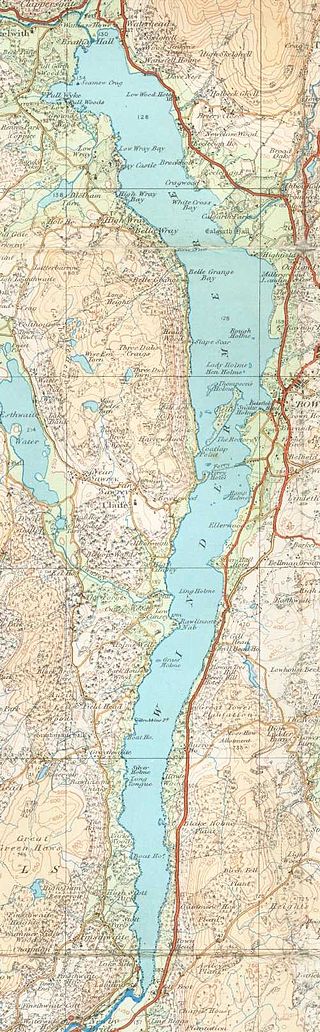
Here’s the map again, just to show where Gozo is in relation to Malta:

shutterstock_105899297

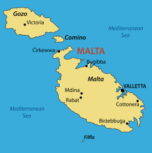
Gozo is the second largest of the three main Maltese islands, and just a 25 minute ferry crossing away from Malta – or 15 minutes by seaplane. The island has been described as ‘Malta’s prettier little sister’ because it’s greener and more rural than Malta. Gozo also boasts an impressive number of historical sites and cultural events and has still-thriving agricultural and fishing industries.

The island has long been associated/equated with that of Ogygia, the home of the nymph Calypso in Homer’s Odyssey. The story tells of how Calypso – who possessed supernatural powers – fell in love with Odysseus, holding him captive for several years before releasing him to continue his journey home.

Our day involved a guided tour, for which we were picked up by coach from our hotel in Bugibba and taken to the ferry port at Cirkewwa on the north-west of Malta to make the short ferry journey over to Gozo with the The Gozo Channel Line.

126

At the port of Mgarr on Gozo, we boaded our next coach and our first stop was the most famous site on the island: the Ggantija Temples at Xaghra.

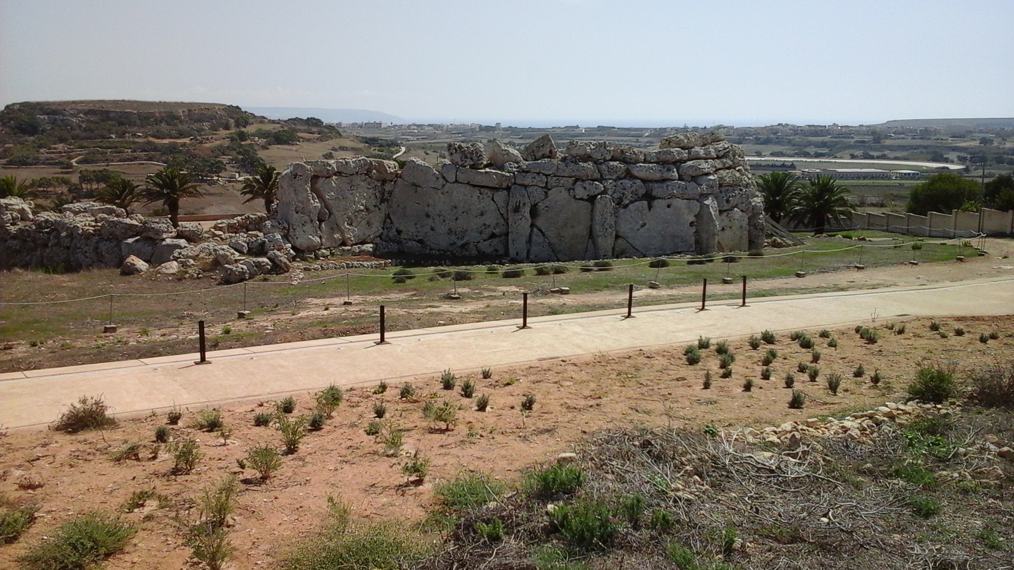
The Ggantija Temples (commonly called The Giant’s Tower in the past) are the earliest of the megalithic temples on the Maltese islands and possibly the oldest, free standing megalithic structures in the world, dating from around 3,600 years BC – older than the pyramids of Egypt. Today the site is a UNESCO World Heritage Site. This is a view of the outer wall:

Outer temple wall

Ggantija consists of two separate systems of courtyards, not interconnected, known as the South Temple and the North Temple. The South Temple is the bigger and earlier (3,600 BC) of the two, the North Temple being a later addition (c. 3,000 BC). The North Temple has a five-apse structure, the South Temple has four.

Ggantija Temple structure

These are some of the photos of the site we took as we walked around it:

The stone spheres (top right photo above) were thought to have been used as a method of moving the great slabs of rock. The entire temple complex was built out of two types of rock: the harder Coralline limestone for the outer walls and the softer, golden Globerigina for the doorways and floor slabs -though some of the floors were just covered with beaten earth (torba).

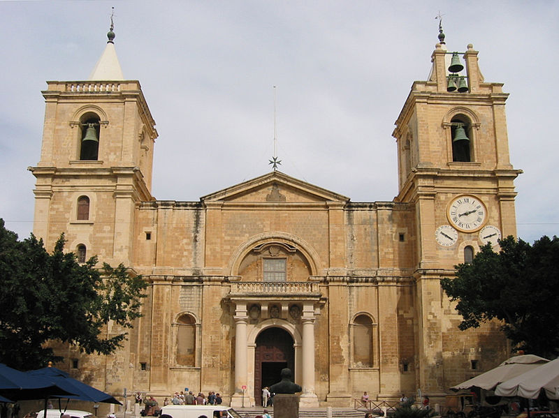
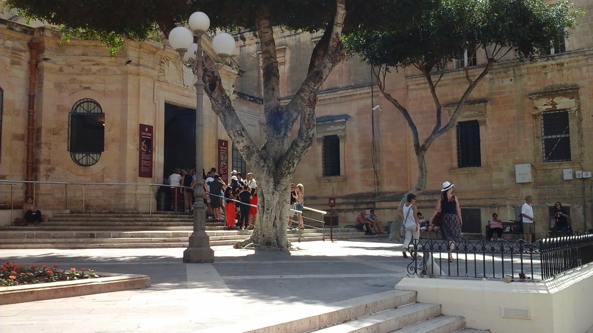
Many of the slabs were once covered with the spiral and pitted designs common to all the Maltese temples. These are some seen in the Archeological Museum in Valletta, from the Tarxien Temples on Malta, which show how some of the stones at Ggantija there would have been decorated:

024


At Ggantija, the spirals can now hardly be seen, although they were visible when the temple was discovered in 1826, suggesting there must have been a roof of some sort to preserve them.

The huge megaliths of the outer wall were positioned alternately, one vertically and one upright, and the space between the outer and inner walls is filled with earth and rubble. It is thought that it was this that has given Ggantija the stability to survive 5,000 years.

In the South Temple, the great court measures twenty three metres from apse to apse and the walls here are eight metres, the highest of all the temples. Arches weren’t used at this period, and since the span of the apses was quite large for any stone roofing to be used, it is thought that the roofing material would have been wood or animal hides.

Here is a picture of the interior I found on Wikipedia:

Engraving of the temple made in 1848, title: 'Gozo (Giants' tower)'. Photographer: Marie-Lan Nguyen (2013). Public Domain. Wikimedia Commons
Engraving of the Ggantia megalithic temple in Gozo made in 1848.  Title: ‘Gozo (Giants’ tower)’. Photographer: Marie-Lan Nguyen (2013). Public Domain.
Wikimedia Commons

The interior walls were plastered and painted with red ochre, traces of which have been found. It’s interesting to speculate just how this place must have looked 5,000 years ago, and on how all the ceremonies would have taken place at the altars and libation pools. Circular holes have been found in some of the larger floor slabs and, although their purpose isn’t clear, it has been suggested that they were used for the pouring of liquid offerings. One slab, shown below, is marked on the side with pitted decorations:

159

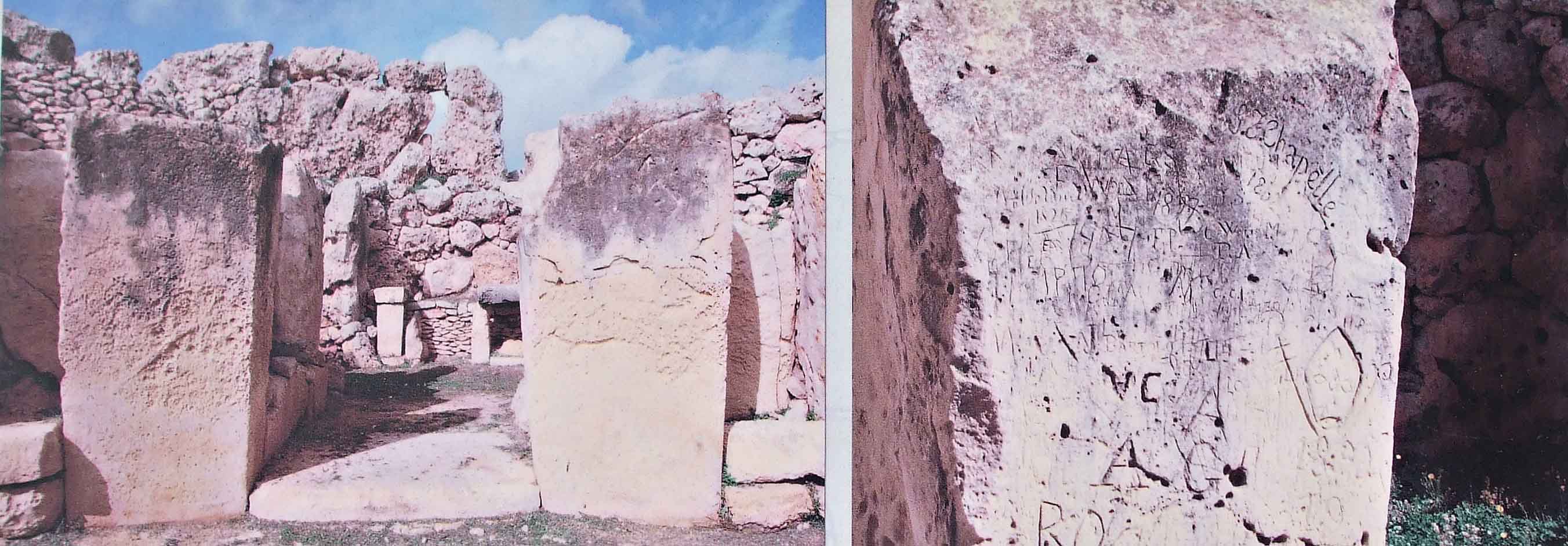
On each side of the door leading into the temple are hollows carved opposite each other on two large megaliths (two pictures in the gallery above – second and last rows). It is thought that these held some sort of barrier – a door or a bar, perhaps both at different times – to close the entrance.

Finally, I couldn’t finish without showing yet another example of graffitti (as at the Mosta Dome). This fine artwork dates from the 1800s:

Graffiti Ggantija


***

The Lure of Lakeland

DSCF1117

This post was intended to be my piece of extra information to accompany my story for FFfAW (here). As it became rather long (although it’s more pictures than information -some photos my own, others from Wikipedia) I’ve made it into a separate post. It’s about an area of England I’ve loved since I was a child – the Lake District. The information includes a little about the area today, and a little about it in the days when it was part of the old Celtic kingdom of Rheged, where my story takes place. 

The Lake District – also known as The English Lakes or just Lakeland – is one of England’s most popular holiday destinations. It is one of the 13 National Parks of England and Wales (No. 2 on the first map below) which today is situated entirely in the county of Cumbria:

National_Parks_in_England_and_Wales
National Parks of England and Wales. Author: Keith Edkins. Creative Commons.
800px-Lake_District_National_Park_UK_location_map.svg
Map of The Lake District National Park. Source: Office of National Statistics and Geography OpenData. Author: Nilfanion. Commons

People are drawn to this area by the natural beauty of its mountains (fells), forests and many lakes. The highest mountain in England, Scafell Pike, lies within the Park’s boundaries . . .

cafell massif showing Scafell Pike. Author: Doug Sim Commons
Scafell massif showing Scafell Pike. Author: Doug Sim. Commons

. . . as does the longest and largest lake, Windermere . . .

Windermere, lake district, from hill. Author: Abbasi 1111. Commons
Windermere, Lake District, from hill. Author: Abbasi 1111. Commons

. . . and the deepest lake, Waswater (also shown on my first photo):

DSCF1118

Unfortunately for the many holidaymakers, it does rain a lot up there! Seathwaite, in the Borrowdale area, holds the record for being the wettest inhabited place in England (130 inches of rain per year). But the many old towns tend to have lots going on, as we noted when we were in Keswick a couple of months ago:

100

Evidence of glaciation during the last Ice Age, can be seen all over the Lake District. I won’t go into the many features other than those of the lakes. As the great glaciers moved out from the centre of the upland region, it gouged out the existing V-shaped valleys into the familiar U-shaped valleys with the ‘ribbon’ lakes we see today – as clearly shown on this O.S. map of Lake Windermere and the picture of Thirlmere below it:

Windermere2cropped3. Public Domain.
Windermere2cropped3.
Public Domain.
A Herdwick sheep grazing above Thirlmere. Author: Sara Blaxkova. Commons
A Herdwick sheep grazing above Thirlmere. Author: Sara Blazkova. Commons

In the Lake District, the lakes radiate out from the central upland like the spokes of a wheel – which you can see in the second map on my post.

The area around Lake Windermere is one of the most popular tourist areas of the Lake District. Steam vessels of the late 19th century carried tourists the length of the lake . . .

800px-Windermere,_steam_ferry,_Lake_District,_England
Windermere Steam Ferry, Lake District, circa 1895. Author: The Library of Congress@Flickr Commons. Public Domain

. . . and nowadays modern ferries run continuously, many tourists heading for the town of Bowness (where we got off) halfway along the lake, or to Ambleside in the north.

MV Swan on Lake Windermere, 2006. Creative Commons

There’s plenty to see along the route: there are 18 islands, various old buildings and private villas, and lots of yachts and other craft moored along private jetties. And motor boats and water skiers provide plenty of entertainment.

Other tourists visit The Lake District simply to see the land so loved by poets such as William Wordsworth and Samuel Coleridge, and the children’s author, Beatrix Potter. Wordsworth’s house in Grasmere, Dove Cottage, is a honeypot for tourists:

Dove Cottage at Grasmere, home of poet, William Wordsworth, now a museum. Author: Christine Hasman. Commons

So many other books have been set in this wonderful place – Swallows and Amazons for one – and many contemporary ones.

Cumbria, along with parts of what is now Southern Scotland and further south, the English county of Lancashire, were thought to have once been what was the the Celtic Kingdom of Rheged, although its exact location and extent are still uncertain.

Yr Hen Ogledd 550 650 Koch by myself. Creative Commons

I won’t go into detail about this kingdom, except to say that it survived well into the 7th, possibly 8th century, when it was annexed by the Anglo-Saxon kingdom of Northumbria. Rheged had been a powerful kingdom in its time.  King Urien in particular (c 530-590) is well known, having been written about by his bard, Taliesin. Both Urien and his son, Owain, became heroes in the stories about King Arthur and his fight against the invading Anglo Saxons. The Brynaich and Deifr on the map above became the A.S. kingdoms of  Bernicia and Deira – which both became a part of Northumbria.

*

Finally, below is another of the the Lake District’s attractions – the Neolithic stone circle at Castlerigg – about which I have a post to do sometime soon.

084

Reunion and Farewell To The Barons

117 Farewell Header

On Sunday morning we drove once again up to Lincoln Castle. This time, it was to have a look at an event held in the castle grounds called ‘The Lincoln Barons’ Reunion’. The photo of the Baron above is the ‘Baron of the Crystal Hues’. (Unfortunately, my husband’s shadow is hiding his name!)

This event, held from Thursday, September 24th until Tuesday, October 1st, is a chance for people to see all 25 Barons together before they’re auctioned on the evening of October 1st. The money raised will go to the national charity, The Trussell Trust – who organised the construction and displaying of the Barons in the city, along with Lincoln BIG, a business improvement group.

The Baron’s Trail was devised by ‘Wild in Art’ – an organisation that aims to make creativity and enjoyment of art accessible to people by working with artists, communities and schools and producing high profile and popular events. Individual artists from all over the country created the colourful barons, which have been displayed in locations around Central Lincoln throughout the summer. This one, the ‘Anything Goes Baron’ was standing on the bridge over the River Witham along the High Street:

066 Baron 7

I wrote about the reason for ‘The Barons’ Trail’ in an earlier post but, in a nutshell, it was part of the city’s celebrations to mark 800 years since King John signed the Magna Carta (Great Charter) at Runneymede. One of the original copies of the Treaty is housed in Lincoln Castle, so the city was justified in hosting so many celebratory events.

The Barons who ordered John to sign the Treaty are represented in these life-sized, smile-inducing models we are now saying ‘Goodbye’ to. Last week, they were gathered up from their different sites and I’ve no doubt that the area will look quite dull without them. They’ve been a big attraction for locals and tourists alike, the characterful barons and the ‘Trail’ proving to be one of the highlights of the Magna Carta anniversary celebrations nationwide. Children in particular found it great fun to find the code letter on each one in order to claim the promised bag of gold coins (gold paper-covered, chocolate ones, of course).

There were a lot of people already in the castle grounds when we arrived just after 10 am – the opening time. Consequently, it was difficult for photo-taking. We’d hoped to be able to get a few good shots of many of the Barons all together, but that wasn’t at all easy. Firstly, the barons were placed further apart than shown on the advertising blurb, and secondly, people were standing close to individual Barons. That’s understandable, so we just went with the flow and got some ‘not-so-good’ photos.  Here’s  a few of them:

A mini ‘Paint Your Own Baron’ can be bought at The Lincoln Visitor Information Centre (shown below in the wonderful old building located on Castle Hill, between the castle and the cathedral) and a competition to win a free mini model of a Baron is also up and running. And finally, every shop in the city centre will be given their own mini Baron to paint and decorate in time for the Christmas season. By doing so, they will be creating a Christmas Baron’s Trail. These mini characters, unlike their bigger brothers, will be harder to find. Many will be ‘ hiding’ amongst other items displayed in the windows of shops and businesses.

I’ll probably do an update on the mini barons around Christmas. Hopefully, we’ll be able to find and photograph some of them in their hiding places. Until then, I’ve got a few more posts on Malta and other places we’ve visited this year to keep me going.

‘Miraculous’ Mosta.

152 (1) +

Mosta is a town in the Northern Region of the Malta. It has a population of 20,241 (in 2014) and is one of the larger towns on the island. It sits roughly at the geographical centre of the Maltese Islands, making it a crossroads for people travelling from the south and east to the north. As such, a lot of traffic comes through its narrow streets. The image above, taken last year, shows a view of Mosta from Mdina, three miles away.

Location of local council XY (Mosta region) in Malta. Author TUBS. Commons
Location of local council XY (Mosta region) in Malta. Author TUBS.
Commons

The remains of people who lived in the Mosta area date back to the Copper Age (4100-2500 BC). The actual name of ‘Mosta’ is of ancient origin – some claiming it to be linked with the legendary Atlantis. Other suggestions include ‘mysterious village’, the ‘hidden place’ and the more widely accepted ‘central place’, which is derived from the Arabic for ‘centre’.

As a village, Mosta never stood much chance of development until the late 17th century. It was always too accessible to marauding pirates who could make their way from the sea along the Madliena Valley. The people’s only hope of defence was to make it to Mdina, three miles away, or to one of the stronly defended stone farmhouses – or  to retreat behind the doors of their own church.

In the 18th century, the Mostin (people in the Mosta area) decided that their own church was both inadequate for the population size -which had reached 3,000 by then – and structurally unsound. Eventually, between 1833 and 1860 a new church was built – using funds raised by the local people. It was formally blessed in February, 1860.

Today, this church is what draws thousands of tourists to Mosta – and not just because of its impressive appearance, which I’ll talk about in a moment. We’ve been there twice now, on this occasion purely to take some photograghs. The last time we visited in 2003 we took very few. It’s called the Church of St. Mary of the Assumption, commonly knows as the Mosta Dome, or Mosta Rotunda:

012

The church was designed by French-born, Maltese architect Giorgio Grognet de Vasse, and was modelled on the Pantheon in Rome. Grognet reportedly tested slabs of rock from every quarry on the island before settling for the lovely, golden limestone from Ta’ Venezja quarry at Ta’Qali. It was built around the framework of the old church to allow people to continue attending mass. The huge, heavy limestone dome was built without the use of scaffolding – quite a feat – and the old church was only dismantled once the new one was complete.

Here are a few more photos of the outside of the church – which is  soon to be re-classified as a Basilica. The two black statues are of St. Mary of the Assumption (left) and St. Joseph. There are also stone statues of various saints set behind the pillars. It also seems that nowhere is safe from the dreaded graffiti. The picture shown below was taken close to the front entrance:

And these are some views of the highly decorated, blue, gold and white interior. The great size of the dome is deceptive in photos – it’s actually 37.2 metres wide. Some sources say it’s the third largest unsupported dome in Europe and ninth largest in the world. (Sources vary on this! I’ve come across some that say third largest in the world and some that say it’s fourth largest in the world. I think it depends on what criteria are used in making comparisons.)

Other than the beautiful building, the thing that draws many tourists to the Mosta Dome is the story of an event that occurred on April 9th 1942, during the Siege of Malta in WW2.

On that day, four German bombs hit the Rotunda. Three of these did not explode and one penetrated the dome and landed in the middle of the church. The reason for the bomb-drop is unknown; as a central village, Mosta is a long way from ports and airports and, until that day, hadn’t been a target for bombing. But the town was in the flight path of German bombers heading to or from the RAF base at Ta Qali – which could well explain the drop.

None of the 3oo people present suffered any injury – and the Mostin see the reason as divine intervention.

The bomb – a 500kg Luftwaffe high explosive – was defused by Royal Engineers Bomb Disposal Sections and, like all neutralised bombs on the island, was taken to the west coast to be dumped in the sea.  It was one of the 7,000 bombs dealt with by R.E. Bomb Disposal Team in two years.

In one of the two the sacristies a replica of the  the bomb is on display along with a few other pictures and models of the church:

Well, that’s it about the Mosta Dome. It’s well worth a visit should you go to the island . . . depending on your interests, of course. There are sites to suit all tastes on Malta, and I’ve still got a lot of them to see.

Vibrant Valletta

191

Last Monday, September 14th, we had one of our many trips into the city of Valletta. I had intended to do this post whilst we were still in Malta but, unfortunately, time did not allow.  So here it is now . . .

Built on the Sciberras peninsula in the central-eastern part of the island,Valletta is the capital city of Malta. With a population of only 6,400 (in 2014) it is Europe’s smallest capital. It was described by Sir Walter Scott – who came to the island on doctor’s orders in 1831 – as ‘a city built by gentlemen for gentlemen’ and ‘that splendid town quite like a dream’. The colloquial name for Valletta is simply, ‘il-Belt’ (The City). Valletta is a city rich in sites to see, with historical buildings and wonderful statues, fountains and coats of arms at every turn.  In 1980, it was officially recognised by UNESCO as a World Heritage Site and in 2012 it was named as European Capital of Culture for 2018.

These maps give an idea of Valletta’s location and the two harburs it dominates:

766px-Malta_Regions_map
Map of Malta and Gozo. Creative Commons License, Attribution- ShareAlike30
Valletta,_Malta
Satellite view of Valletta. Author: NASA Astronaughts. Uploaded by Aresceo. Public Domain.

The foundation of Valletta dates back to 1566 when Grand Master Jean Parisot de la Valette (statue of him, above) laid the first stone. Following the attacks by the Ottoman Turks in the ‘Great Siege’ of the previous year, Valette knew that the island’s defences greatly needed improving. He decided to build a new, well-fortified capital next to the already established watchtower at Saint Elmo Point on the tip of the Sciberras Peninsula. The city was originally planned as one of winding streets and alleys but, in order to speed things up, a grid design was adopted – which is still seen today.

The many narrow side streets are full of quaint old shops and cafes, and on the main street, Rebulic Street, larger shops sit side by side with the older buildings. Here are a few of the photos we took along Republic Street:

And here are a few of the little side streets:

One of the main buildings along Republic Street is St. John’s Co Cathedral, described by Sir Walter Scott in 1831 as a ‘magnificent church, the most striking interior I have ever seen’. We didn’t take a good photo of the exterior, so here’s one from Wikimedia Commons, by Radoneme . . .

800px-St_Johns_Co-Cathedral

. . . and one we took of people queuing to get inside:

149

The interior is stunning, but I won’t go into that now, except to say that it was decorated by Mattia Preti, and some of his great pieces of art are also displayed there. But perhaps the most famous piece of art on display is by Caravaggio – whose own life story is fascinating, tempestuous – and very controversial.

Beheading of John the Baptist by Michelangelo Caravaggio. 1608 Public Domain

This is the only one of his paintings that Caravaggio signed:

800px-Decollazione_di_San_Giovanni_Battista_(particolare_1)
Signature in blood beneath St. John’s head. Public Domain

The title of European Capital of Culture is given to cities which, according to the Minister for Culture, Mario de Marco, are ‘rich in heritage but would also have a great potential for cultural and socio-economic regeneration’. The ‘City Gate’ project involves the reorganisation of the main entrance into Valletta and the site immediately outside the city walls. The new Parliament building (shown top of the first set of photos), the landscaping of the ‘ditch’ and rebuilding of the old Opera House from ruins are also included in the project. This is a photo of the new gate, with photos of the 16th century bastions and ditch below it:

200

The Great Ditch that surrounds Valletta on the landward side was dug and the excavated stone used to build the bastions on that side and also for buildings.

Valletta is well worth visiting. Every time we go we find something we hadn’t seen before. There are many museums, and the lovely gardens Barrakka Gardens . . .

197

. . . and much to see of the defences along the harbour – which I can’t include in this post.

To finish with, here’s a photo of one of the sun shades for horses that pull the carriages for transporting tourists around. The sun shades are relatively new, and I believe they’re a result of complaints from people regarding leaving horses standing in the sun for hours – as happened in Mijas in Andalucia, with the donkeys. I wrote about that in May [here]. The carriages get a lot of use, particularly by people who visit the fort and coastal defences and find the trek back up the hill to the main city area difficult.

100

Marvellous Malta

217 Our week in Malta is almost at an end. Tomorrow we fly home – probably to grey skies and rain – and normality will resume. We’ve been ‘out and about’ every day and taken hundreds of photos of a variety of sites on both Malta and Gozo. I hope to do a few posts when I get home. I had intended to do a post on Valletta –  Malta’s capital city –  earlier this week, but we’ve been quite late getting back to the apartment to do a great deal. But before I do focus on Valletta, I think it would be a good idea to say a little bit about the Maltese  Islands in general. Here are a couple of maps to start with to show where they are located:

EU-Malta_svg
Map showing countries in the European Union (light green) and the location of Malta. Author: Nuclear Vacuum. Commons.

shutterstock_105899297The Maltese archipelago (group of islands) is situated in the Mediterranean Sea, 90km (56 miles) south of the Italian island of Sicily. The three main islands that make up the group are Malta, Gozo and Comino. There are also three small, uninhabited islands. The many rocky coves around its coast form deep, natural harbours, which have featured In Malta’s history since it was first inhabited. Today the island group forms the most densely populated country in Europe.

Flag_of_Malta_svg
Flag of Malta. Licensed under CCO via Commons. Public Domain

(I put this picture in especially for fellow blogger Prateek Kohli. He told me he loved learning about Malta at school because the Maltese flag was so easy to draw. You know… I think he’s right!)

The first people arrived in Malta around 4000 BC – Stone-age farmers from Sicily, who brought their animals, pottery, bags of seed and flint with them. Many hundreds of years later, around 1800 BC, they built wonderful temples on the islands, the remains of which can still be seen today, along with many examples of their sculpture and carved wall decorations: 120 Soon after this time, new invaders arrived and the temple builders disappeared – either through extermination or slavery. And so Malta’s story continues, with a number of different invasions over the years – through the Bronze and Iron Ages, and the Phoenician (800 BC) and Roman invasions. It was the Romans who named the island we call Malta today, ‘Melita’. The name is remembered on the little blue buses, occasionally seen today. The photo of the one above was taken last year when we were in Sliema. The name ‘Melita’ means ‘honey’, and there has been much discussion as to why this name was given to the island. My first though was that it was because of the wonderful honey-coloured rock which comprises most of Malta. 146 Very few buildings are constructed of any other stone, and from the air the island looks decidedly yellow – especially after the dry summers, when vegetation is well parched. Another theory regarding the name is probably more likely. The island was covered in wild thyme – and bees just love thyme. Being the enterprising people they were, the Romans made good use of that fact and kept lots of bees. There is evidence for their hives in various locations, and they probably considered this fertile and beautiful island their little ‘honey-pot’. The Romans built their capital city where the modern Rabat/Mdina are situated. They called that city, Melita, too.

Since Roman times, Malta has seen Byzantine rule, followed by that of the Arabs who invaded in 870. Arab rule continued until the Normans arrived, and in about 1298, the then homeless Knights of St. John (also known as the Knights Hospitallers) made the island their new home – a home that was to last until the 18th century.  They made improvements in Malta’s defences, but it was not until the attacks by the Ottoman Turks started in 1547 that defences were strengthened in earnest.

The ‘Great Siege’ of 1565 is so well documented, and I won’t go into it now. But eventually, the Turks were driven back and the Knights of St. John continued to improve the island. It was Grand Master Jean Parisot de Valette who ordered the building of the new capital city of Valletta. (And yes, Valette’s name does only have only one ‘l’ and isn’t another of my typos). Here is a picture of him:

Malta: Valletta - the Great Master Palace portrait of the Grand Master Jean de la Vallette-Parisot (1557-1568), founder of Valletta Photo by Giulio Andreini
Malta: Valletta – the Great Master Palace
portrait of the Grand Master Jean de la Vallette-Parisot (1557-1568), founder of Valletta
Photo by Giulio Andreini, edited by Clive Gerada. Public Domain

Life was not easy for the people under the Order of St. John; rules were strict and punishments extreme. But by the latter part of the 18th century, the Order started to deteriorate and when Napoleon invaded, the last Grand Master surrendered without resistance. French rule lasted until the British took command in 1814. Complete independence for Malta came in 1964, although self-government had already been granted in 1921.

I couldn’t write about Malta’s history without saying a little about the island’s amazing bravery during WW2, for which it was awarded the George Cross, Britain’s highest civilian honour for bravery.  As it had done throughout history, Malta’s location again meant it played central stage – and, as such, the Islands ended the war completely devastated. Malta holds the record for the heaviest, sustained bombing attack:154 days and nights and 6,700 tons of bombs.  In 1947, the Islands were granted £30 million to help rebuild. But it took many years and further restructuring once the British forces left Malta completely in 1979, to rebuild the economy.

Bomb damaged Kingsway (now Republic Street) during the Siege of Malta in 1942.. Author: Russell J.E. (Lt.) Royal Navy, official photographer. Public Domain.
Bomb damaged Kingsway (now Republic Street) during the Siege of Malta in 1942. Author: Russell J.E. (Lt.) Royal Navy, official photographer. Public Domain.

The Maltese islands offer so much to holidaymakers. They have everything from delightful coves and fishing villages to wonderful archaeological sites and bustling cities and towns. There are many museums that focus on the various historical periods, many cafes, restaurants and bars. The beaches are not striking in some areas, being narrow and rocky, but there are sandy beaches to be found – the most notable and largest at Mellieha Bay in the north of Malta. It has been described as one of the best beaches in the Mediterranean.

The Maltese language is fascinating, with words stemming from the many past invaders’ languages. The Arabic sounds are prevalent, with some words being more like Italian. ‘Thank you’ for example is ‘Grazie’. Most people on the islands also speak English, which is taught in all the schools. This is definitely a bonus for us, as neither of us speak Maltese!

This last image is of the famous Maltese Falcon set against the Maltese Cross:

shutterstock_107566154

One Day Spent In Malta… Already!

125

We’ve been in Malta since 12.30 pm yesterday, Saturday, and I can tell you, I’m loving the sunshine! Today, temperatures hit 37° in Bugibba, where we’re staying. Not quite as high as the 40-45° we had in Andalucía in May, but still very hot after the miserable weather we’ve had at home most of the summer.

So far we’ve not been too far on the island. We spent the morning by the pool and I had a nice long swim… well, as nice as it can be will lots of people in there. This afternoon we had a walk along what we’d call a ‘promenade’ at home – i.e. along the seafront. So I just thought I’d post a few photos of the hotel and town…

But first, I’m putting up a few snaps of the hotel we stayed at near to Gatwick airport, before flying out here. It’s one of the Millennium  group of hotels, and it’s at the village of Copthorne. We’ve stayed there a few times and always leave the car there. It’s nice and old, and it has a swimming pool – always a bonus for me. Regular shuttle buses run back and forth to the airport, or the hotel will organise taxis on request – which we usually do. It’s a fifteen minute ride. Anyway, here are a few pictures I took when we went down for a meal. It was dark by then, and the polished floors really gleamed! This first photo is of a screen in the reception area with some information about the history of the hotel. It moved from one image to another quickly, and I had a bit of a job catching it – so excuse the poor alignment. (Click on it if it isn’t readable.):

016

Here are a few of the other photos I took:

And now to Malta…  These are a few photos from our apartment windows in Bugibba, Malta. They were taken at different times, some mid-afternoon, some at sunset, and one just after sunsrise this morning. (We are facing north).

These photos were taken along the promenade/sea front this afternoon. Two show views up  typical Maltese side streets; others show shops selling ‘seaside’ goods, or offering a variety of excursions. There were lots of places selling ice creams – with almost as many flavours as we saw in Italy!

We took so many photos today, far too many to show here. Tomorrow we’re going to lovely Valletta. We spend a lot of our time there because it’s just amazing. Bugibba’s OK as a base, but it’s not the best place for us. We got this time share years ago, and it’s handy to have. But we’d much rather be in Valletta…

***

The Sealed Knot At The Village Show

151 First image

Last Sunday, September 6th, we drove eight miles out to the village of Sutton-on-Trent, where the locals were putting on their village festival.  But this was a village show with a difference, because it was visited by a regiment of the Sealed Knot.

010 Second image

The Sealed Knot is the oldest re-enactment society in the UK and the single biggest re-enactment society in Europe. It aims to honour those who died in the many battles of the English Civil War (1642-49) and to educate people about those battles and the life of people during that period. Events are staged throughout the country all year. The name, The Sealed Knot, comes from that of a secret association that aimed to have the monarchy restored during the Interregnum/Commonwealth – the period between 1653 and 1659, when the country was governed by a Lord Protector, Oliver Cromwell. The present society, however, has no political affiliation.

Their events vary in size: a major battle lasts for two or three days, and can see thousands of combatants taking to the field. On this occasion The Sealed Knot did not come to stage a battle. It was a fairly small group, visiting only to demonstrate a few weapon skills and battle formations. They did have their 17th century muskets and pikes, but no cannons this time. Some photos later…

The show was held on Saturday and Sunday and both days were well attended. A variety of stalls and exhibits were arranged around the outer edge of a village field, including local produce, farm machinery and vintage cars and motor cycles. There were also several refreshment stalls.

In the central area, known as ‘The Hollow’ (because it’s a step down from the outer edge) displays were put on at various intervals by The Sealed Knot, Dako’s Flying Angels (a group of gymnastic lads) and the Whitwell Brass Band. There was also someone doing keep-fit with younger children and others hosting a doughnut eating competition. On Saturday, there had been a dog show. The threshing machine, standing right at back of the field was also demonstrated:

In another corner of the L-shaped field, was the small encampment of The Sealed Knot:

The Sealed Knot displayed their skills twice during the day. Here are a few photos:

And to finish with, here are a few photos of the many vintage cars and motorbikes exhibited:

All in all we had a really fun and interesting time. It was sunny and warm, and the ice creams we had really made my day!

Steaming Through History


DSCF4977 (2)

This post is intended to accompany my story for this week’s Flash Fiction for Aspiring Writers (here). Having a grandson like Kieran (now sixteen) who has been mad about steam engines since losing interest in Thomas the Tank Engine when he was four…

shutterstock_158241434

… we’ve had a good few years to visit lots of places where steam locomotives can be seen. Such places include museums and historical, working railways and associated events. We also dash to Newark, Lincoln or Grantham stations when particular engines are passing through. It’s amazing how many steam fanatics do the same thing. These events are always packed.

So, here is a quick look at the history of steam locomotives…

Steam locomotives were first developed in Britain in the early 19th century. Their use transformed the world, carrying people and goods at hitherto unthinkable speeds around the globe, and dominating railway transport until the middle of the 20th century, when they were replaced by diesel and electric locomotives.

The creation of steam locomotives began with the development of the steam engine. In 1698, Thomas Savery patented a machine that used steam to pump water out of the mines. His design was later improved by Thomas Newcomen in 1712 and further still by James Watt in 1763. It was Watt’s improvements to the steam engine that led the way to the steam locomotive.

Newcomen Engine (2)
Newcomen Steam Engine. Author: Newton henry Black, Harvey Nathaniel Davis. Public Domain. Wikimedia Commons.

The first steam locomotive was made by Richard Trevithick in 1804. It was called the Puffing Eagle. Trevithick was a tall, strong Cornishman, described by his schoolmaster as ‘obstinate and inattentive’, who learnt his craft in the Cornish tin mines. He later moved to South America before dying penniless at the age of 62. But his idea was developed by others, and by 1845, 2,440 miles of railway were open – used by 30 million passengers in Britain alone.

trevithick (2)
Painting of Richard Trevithic. engineer, !816. Author: John Linnell. Public Domain. Wikimedia Commons

Another well-known early locomotive was the Puffing Billy built by engineer William Hedley in 1813-14 and is the oldest one preserved, and on display in the Science Museum in London.

puffingbilly (2)
Puffing Billy (the oldest surviving steam locomotive in the UK). Location : Science Museum, London. Author: Arkady Rose. Creative Commons.

George Stephenson built the Locomotion for the Stockton and Darlington Railway in north-east England, the first public steam railway in the world. In 1829 he built The Rocket, which won the Rainhill Trials and established his company as the foremost builder of steam engines used on railways in the UK, US, and much of Europe.

stephensons rocket (2)
Stephenson’s Rocket drawing. Public Domain. Wikimedia Commons

The first steam locomotive to run in the U.S. was shipped from Britain and called the Stourbridge Lion. It was ordered for transporting coal but, at 7.5 tons, it was too heavy for the tracks which were intended to hold 4 tons. Another locomotive imported from Britain was the John Bull.  

stourbridge lion (2)
First run of the Stourbridge Lion, August 8, 1829, in Honesdale, Pennsylvania. Painted 1916. Public Domain. Wikimedia Commons

The first steam locomotive built in America was the Tom Thumb, which had its first run in 1830 on the Baltimore and Ohio railroads. It carried 36 passengers and travelled at 18mph.

tom thumb peter coopers iron horse (2)
Replica of Tom Thumb, first American built locomotive designed by Peter Cooper. Author: E.T. Kenney. Public Domain. Wikimedia Commons

The first railway service in Continental Europe was opened in May, 1835, in Belgium, between Mechelenand and Brussels. The locomotive was The Elephant.

Today, most steam locomotives still in use are for historical, educational or entertainment purposes. Railway museums have many interesting exhibits, and I have a post to do sometime on the National Railway Museum in York, which I visited (yet again!) two weeks  ago with Kieran and other family members. We’ve come a long way since Trevithick launched his first practical steam locomotive in 1804. Today, several high-speed trains are regularly travelling 30 times faster. Japan’s first bullet trains in 1964 were capable of running at speeds more than 130mph. The world record speed today is 361mph!

shinkansen (2)
Line up of Sinkansen trains. Author: Author: User Pagemoral. Creative Commons

But Japan is no longer alone in the high-speed rail department. France, China and Germany all operate trains capable of similar extreme speeds. Plans are also underway to construct a high-speed rail line connecting the Californian cities of San Francisco and Anaheim.

Refs: Wikipedia; Custom-QR- Codes.net; historic-uk.com

Magna Carta Sand Sculpture at Lincoln Castle

008 (5)

This is my fourth and last post about King John and the Magna Carta – a short one this time, following another trip to Lincoln this afternoon. We went specifically to take a few photos of the newly created sand sculpture in the grounds of Lincoln Castle:

008 Sand Sculptures (4)

This impressive, 3D sculpture is 13ft. (4m) tall and 30ft. (9m.) wide. Work started on August 17th and continued for two weeks. It was created as part of the celebrations marking the 800th anniversary of the signing of the Magna Carta (Festival800) and depicts King John meeting with the barons at Runnymede in 1215:

007 Sand Sculptures (1)

Its creators were the world renowned Dutch artist, Remy Hoggard and her husband, Paul, originally from Beverley in East Yorkshire. Between them, the couple have more than 30 years experience of sand sculpting. Of their sculpture at Lincoln, Paul Hoggard said, ‘This is probably one of our most adventurous projects in terms of size and scale…after fourteen days of shovelling, pounding, shaping and sculpting we were physically aching and are ready for a few days’ rest.’

The end product is quite awesome and well worth seeing.

The couple now live on a farm in Bulgaria, but spend most of their time travelling around the world, creating amazing sand sculptures. Remy said about their work: ‘With sand and water we make very detailed two or three-dimensional works, as well as large sculptures, in a relatively short amount of time.’

The brief video I found to finish with shows the delivery of the sand and the artists discussing the work about to be undertaken: