The Royal Armouries Museum in Leeds

armouries-symbol-henry-8s-horned-helmet

On Sunday we headed up to Leeds in West Yorkshire for another visit to the Royal Armouries Museum. It’s a 70 mile journey from where we live near Newark and took us about an hour and twenty minutes. We’ve been to the museum a few times now, and it’s always an enjoyable visit – and despite (or perhaps because of) it being only January, the place was pretty busy.

The Royal Armouries is the UK’s national museum of arms and armour and one of the most important museums of its type in the world. The core collection has its origins in the country’s working arsenal in the Tower of London, as far back as the Middle Ages. The collection of approximately 75,000 items – excluding 2,7000 on loan – is housed and displayed at three sites: the collection’s historic home at the Tower of London, the purpose-built building in Leeds, and at Fort Nelson, near Portsmouth in Hampshire.

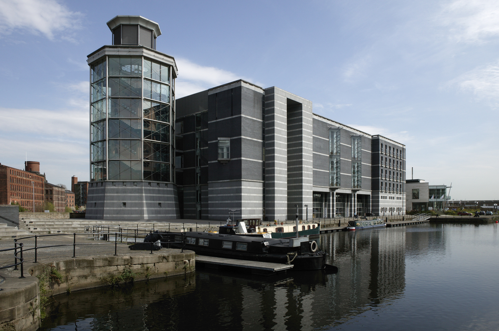
Situated close to the city centre, the museum is among many buildings built in the same era (mid 1990s) which saw a rejuvenation of the area now known as Leeds Dock. The actual Leeds Dock forms the junction of the Leeds-Liverpool Canal and the Aire-Calder navigation. Good views of these waterways and the connecting lock, can seen from the different floors inside the museum:

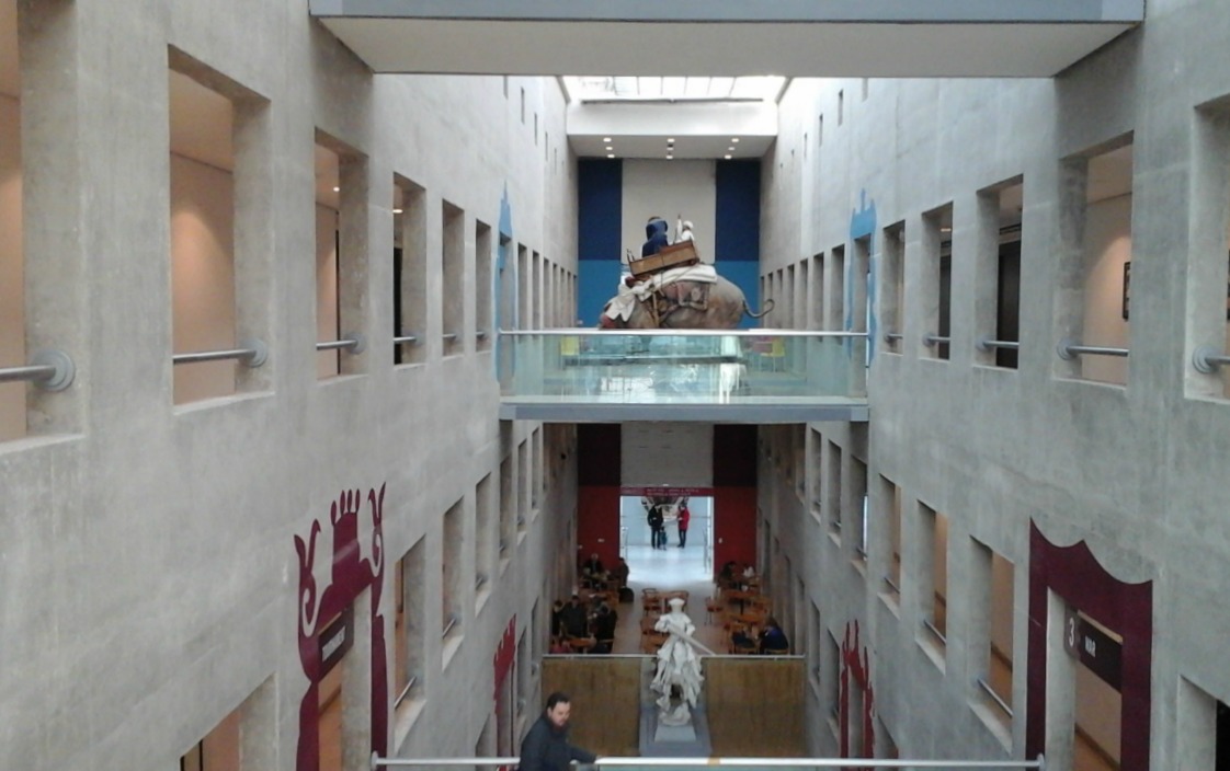
The exhibits are spread over five floors. Once through the main entrance, the ground floor consists of main passage through to the Hall of Steel. To either side of the passage are a theatre and meeting rooms as well as the first of two cafes (the other is on the second floor) and the souvenir shop:

At the far end of the ground floor is the Hall of Steel, a steel and glass tower described in the guide book as ‘the architectural centrepiece of the Royal Armouries’. The stairs to the different floors circle around inside it (and through which the best views of the waterways can be had).

shutterstock_554352385

The displays around the central stairwell are excellent and consist mainly of weapons and armour from the 17th century.

Floor 1 consisted of the Education Centre, Library and Wellington Suite – so we hurried on to Floor 2:

looking-down-from-floor-2
Looking down at the ground floor from floor 2.

Floors 2 and 3 are all devoted to War, with displays of weapons and armour over time and how they changed. This is the entrance to the War Gallery on Floor 2:

There are far too many exhibits to show or talk about here, but I’ll show a few of them. The  exhibits in the following set are all connected to Henry V111. His suit of armour is always a talking point (re.the codpiece) as is the horned helmet that was given to him by the Holy Roman Emperor Maximillian 1 (1459-1519) after the defeat of the French at the Battle of Spurs.

The next set is a mixture of other items and displays of interest on Floors 2 and 3. The mounted men from the central display are all men of arms from different countries and times:

On Floor 4 is the fascinating Oriental Gallery. This is a mix of warriors, arms and weapons from several countries, including Turkey, India, China and Japan. Again, here are just a few of the photos we took. I’ve included an elephant used for hunting as well as a war elephant:

Floor 5 continues the theme of hunting started on Floor 4. There are displays of guns and other weapons used for hunting, as well as actual hunting models. I don’t like any form of hunting, nor do I take any interest in guns, which I also dislike. But here are a few photos:

I could only show a mere fraction of the enormous number of exhibits at the Armouries Museum, and many of the photos we took were useless because of the glare from the lights. Most displays were behind glass, which made it even worse, so please excuse the glary pictures. My favourite galleries were the Medieval ones. And Henry V111’s codpiece is a hoot.

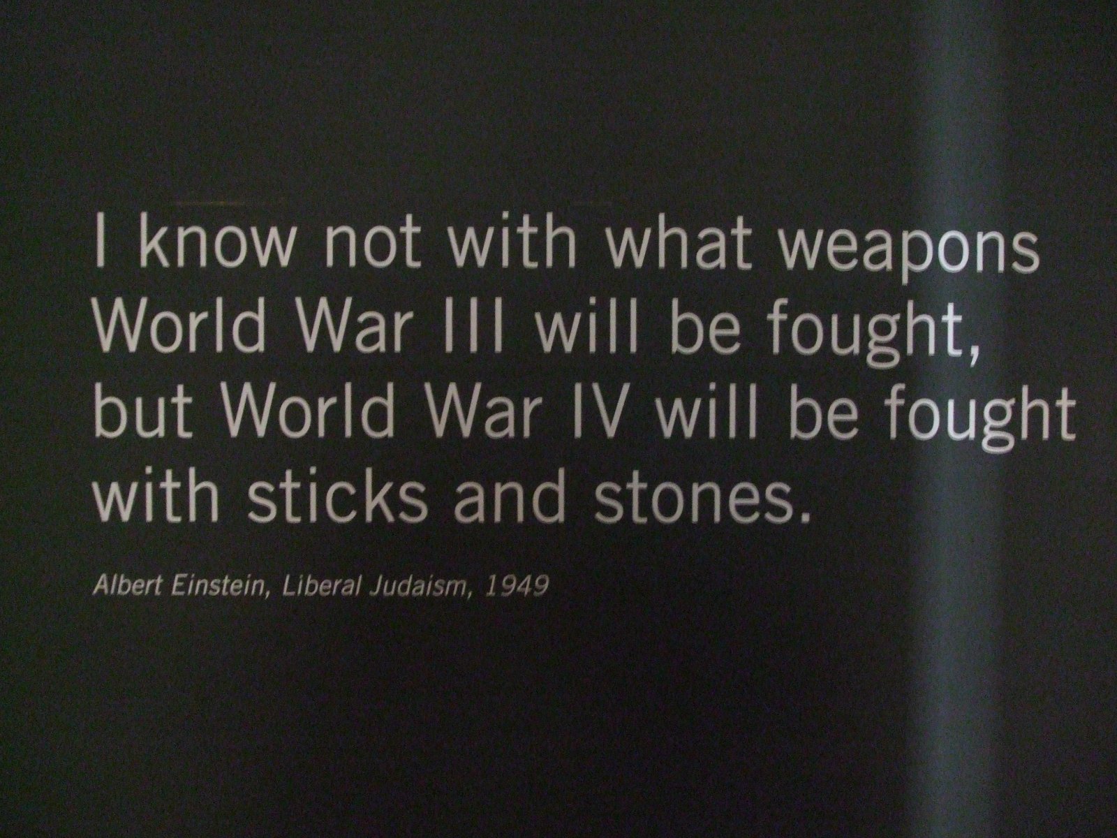
And here’s some food for thought from a wall display in the museum:

einstein-quote


Gullfoss Waterfall with a Shake (Subtitle: I Really Need a Tripod!)

gullfoss-b

I intended to show the video (below) on the post I wrote in early October about some of the sites we’d visited during our holiday in Iceland. (A glimpse of Iceland). Well… I can come up with several excuses for not doing so, but the main ones are simply that I hadn’t got around to getting it onto YouTube – and then, when I did, it looked far too jumpy and shaky to use.

The moral of the story is that for good, ‘steady’ videos we need a tripod. It’s impossible not to be jostled around at popular tourist spots and holding a camera perfectly level whilst moving it along to show different aspects of the feature is a big no-no (for me anyway).

Gullfoss (Golden Falls) is the most spectacular and well known of the Icelandic waterfalls, and we visited it as part of the popular Golden Circle Tour. The roaring noise is fascinating! Anyway, here’s the shaky video:

The second half of this video has somehow been lopped off – which is probably just as well, as it was far worse than the first half!

Here’s a little bit of additional information about these falls, mostly from tourist information boards at the site:

The Gullfoss Falls are on the River Hvitá where it descends from the highlands into the Hvítårgljúfor Canyon.  The waterfall cascades in two tiers into the canyon and is about 31m high. The upper waterfall faces south and is 11 m high, the lower one faces west and is 20 m high. The two tiers can be seen in this photo:

two-tiers-of-gullfoss

For many years attempts were made to buy or rent the waterfall and harness its power, and disputes continued throughout the 20th century.  A woman named Sigridur Tómasdóttir (1871-1957), a farmer’s daughter and later owner of the nearby farm, Brattholt, became ‘standard bearer’ in the fight to protect the Gullfoss, and devoted most of her long life to preventing its destruction.

Happily, Gullfoss and its environs were designated a nature reserve in 1979.

There are a couple of theories as to why these falls became known as the ‘Golden Falls’. The first is because of the golden evening hue which often colours its glacial waters. The second is that the name was inspired by the rainbow that often appears when the sunshine hits the water spray. But I prefer this story, which tallies with all the other fanciful tales abounding in Iceland. It was found in the travel journal of Sveinn Pálsson:

A farmer named Gýgur lived at Gýgurjarhóll. He had plenty of gold and could not bear the thought of anyone else having it after he’d died. (What a meanie!) So he placed the gold in a coffer and threw it in the waterfall – which has been called Gullfoss ever since.

Well that’s the last post I’ll be doing on Iceland – for a while, anyway 🙂

****

Burnby Hall and Gardens

lake-and-water-lilies-3-july

With 2016 racing towards its end I thought I ought to write up about some of the many places we’ve visited around the UK this year. I’ve already posted some of them, as well as a couple of posts about our holiday in Iceland, but I’ve still loads left to do! So I thought I’d start with somewhere we’ve visited twice this year. The first time was in April when trees were only just coming into leaf, and the second in July, when summer flowers were blooming and water lilies patterned and coloured the lakes.

Burnby Hall Gardens wasn’t somewhere we’d set out to visit on our first short break in Yorkshire in April, but we saw leaflets about it in the hotel and thought we’d have a look. And it came as a pleasant surprise. It’s located in the market town of Pocklington in the East Riding of the county.

east_riding_of_yorkshire_uk_location_map-svg
Map of the East Riding of Yorkshire. Source: Ordnance Survey OpenData. Author: Nilfanion. Creative Commons

The Gardens have been described as ‘the jewel in Yorkshire’s crown’ and consist of upper and lower lakes set in nine acres of woodland. There are pathways around the lakes, an ornamental bridge, an aviary, a Victorian garden, a rockery and more recently a stumpery has been added – which I’ll explain about later in the post.

The two lakes are home to a national collection of over a hundred varieties of hardy water lilies which flower between June and August – the reason we visited for a second time in July. The lakes are home to lots of carp and roach which people happily feed with cartons of fish pellets purchased from the shop. The carps’ gaping mouths are very amusing.

When we visited in early April most trees were still bare or just coming into leaf, and blossoms and spring flowers adorned the site. Before I say anything about how the Gardens came into existence, here are a few springtime photos we took:

The site of Burnby Gardens was originally the estate of Major Percy Marlborough Stewart (1871 – 1962) who was descended from the earls of Galloway and the Spencer-Churchills and was the godson of the Duke of Marlborough. The gardens were created when Major Stewart returned to settle at home after eight trips around the world, during which he visited every continent except Antarctica. On some of the trips he was accompanied by his wife, Katharine. He is described in the Burnby Hall and Gardens website as ‘an adventurer, traveller, scholar, philanthropist, collector and environmentalist’. His travelling days apparently started after a remark he made to Katharine:

‘We’re terribly dull people, let’s travel round the world and then we shall have something to talk about.’

Many of the cultural and religious artefacts Major Percy collected can be seen in the museum which is housed in the estate’s house.  Many of these have been recognised by UNESCO as being of national and international importance. (I won’t write about the museum here or this post will become far too long!).

On his death in 1962, having no children and his wife having predeceased him, Major Stewart willed that the Gardens and Collection should be left in trust for the benefit of the people of Pocklington.

Here are some of our summertime photos when the water lilies, in particular, were really beautiful – and the reason we decided to go back to Burnby in July:

lake-at-burnby-in-july

To finish with, a little about the stumpery (taken from an information board at the Burnby Stumpery).

A stumpery is a garden feature constructed mainly from the upturned roots of large trees. The roots are artistically shaped and once in place, plants are used to break up the strong lines and soften the angles. Stumperies have been described as ‘Victorian oddities’ and were popular during the 19th century. The stumpery at Burnby was inspired by the one at Highgrove, the main residence of HRH the Prince of Wales. His stumpery has over 95 sweet chestnut trees and covers 9000 square feet. When his father, Prince Philip, first saw it, he is reputed to have said, ‘When are you going to set fire to this lot?’

Work on Burnby’s stumpery started in 2011 with the removal of 40 dead wych elms (dead as a result of Dutch elm disease) and general clearance of the site. Soil bunds were added to give the stumpery some height. A large quantity of oak stumps were provided by a local Wilberfoss timber agent and the Hobbits’ house in the centre was added for interest.

Environmentally, the stumpery provides for many different species of flora and fauna. Amongst many others, the flora includes many ferns and spring bulbs. Amongst the fauna are grey squirrels, shrews, hedgehogs and occasional rabbits and foxes. Many insects, spiders and snails also make their homes here and the log-like cabins provide excellent ‘bug hotels’ and habitats for hibernating fauna.

This a plan of the stumpery (from the same information board.)

plan-of-the-stumpery

… and some photos which are a mixture of ones taken in both April and July. There were quite a few little Green Men around, too.

Well, perhaps it’s time to say, ‘That’s all for now folks.’

The Hidden Folk of Iceland

Iceland is a truly mystical island. The stunning scenery, with its many hot springs and geysirs, volcanoes and waterfalls and its rugged, rocky coastline lends itself perfectly to the many folk tales that abound. Such tales are deeply embedded in Icelandic culture, and surveys have shown that well over half of all Icelanders believe in the existence of the ‘hidden folk’.  So just who are these ‘hidden folk’ or huldufólk?

In Iceland – and also in the Faroe Islands – the term refers mostly to the elves and trolls, although belief in fairies, gnomes and ghosts is also widespread.

Our guide on one of the tours we went on informed us that in a recent survey, 80% of Icelanders professed to believe in (or at least, they refused to deny) the existence of elves and other hidden beings. Most sources I’ve read online tend to have the figure around 54%, which may simply be based on an earlier survey. But 80% is staggeringly high. Of course, many people worldwide hold beliefs in magical creatures, although it’s generally in the name of ‘fun’. Dragons and unicorns, ghosts and fairies etc. are common topics in many fantasy books and films. In Britain, if something goes wrong, or something disappears, we jokingly blame it on the ‘gremlins’. And in Ireland, we have belief in the leprechauns, another type of fairy, or pixie.

But in Iceland, the hidden people are taken much more seriously.

The origin of such strong beliefs revolves around Iceland’s geographical isolation.  At such high latitudes and out there in the middle of the Atlantic Ocean, with the rest of Europe and North America so far away, life on the island changed little in hundreds of years. Although things have changed greatly in modern times, until little over a century ago, most of the population lived in turf houses, farming and fishing for their living. And with this simple, age-old way of life, superstitions and beliefs from long-gone times, lingered on. Even the Icelandic Christian Church condones these beliefs.

1024px-glaumbaer9
Turf house in Glaumbaer, Iceland. Author TommyBee. Public Domain.

The huldufólk are common topics of conversation among Icelandic people. To upset the elves – particularly by disturbing their homes – can lead to very strange happenings. For example, engineers have been forced to divert the planned routes of roads in order not to disturb the elves.

This short video by Torsten Scholl describes some of the things the elves reputedly did to stop a road disturbing one of their homes:

Trolls are another feature of Icelandic culture that can be seen all over the island, inside and outside of souvenir shops as well as across the countryside in rocky places. They can be seen along the rocky coast, too, as stacks out at sea as well as in the cliffs. Because, you see, many trolls are simply dead!

Trolls are creatures of the night, doing their work and enjoying themselves in the hours of darkness. But as soon as the sun comes up, like vampires, they must rush indoors and sleep. To be caught in the sunlight means certain death: they are turned to stone for all eternity.

This fun video by Sunnefa Palsdottir,  which I really enjoyed, explains all about trolls and is well worth watching, if you have the time:

Yes, Iceland is a country with far more to offer than initially meets the eye. But the huldufólk are never too far away…

A Glimpse of Iceland

Last week we had a short break in Iceland – ‘short’ meaning just five days. In that time we managed to see some of the island as well as the capital city of Reykjavik where our hotel was located. This post is just an introduction to Iceland with a few of the many photos we took over the week. I’ll post about some of the places we visited over the next few weeks. Well, that’s the plan.

flag_of_iceland-svg
Flag of Iceland. Author: Aevar Arnfjord Bjarmason, Zscout 370 and others. Public Domain.

The Republic of Iceland is a sparsely populated Nordic island country located in the North Atlantic Ocean:

iceland_orthographic_projection-svg
Location of Iceland. Author: Ninrouter. Creative Commons

It has a population of 332,529, of which 206,000 – roughly two-thirds – live in Reykjavik, the capital city in the south-west of the island.

800px-map_of_iceland-svg
A map of Iceland showing the major towns, rivers, lakes and glaciers. Translated from a map on the Greek Wikipedia. Author: Max Naylor, 2007. Public Domain.

Iceland’s location on the Mid-Atlantic Ridge, dividing the Eurasian and American continental plates, results in the island being volcanically and geologically active and is famous for its hot springs, geysers and active volcanoes.

rift-valley
Þingvellir National Park (anglicised Thingvellir) looking from the viewing platform on the North American tectonic plate, across the rift valley to the Eurasian plate. This is the site of the foundation of the Icelandic parliament, which I’ll write about in another post, and is now one of the most popular tourist destinations on the island.

There are 130 active and dormant volcanoes in Iceland, eighteen of which have erupted since the first settlers arrived around AD 900. Perhaps the best known ones are Hekla (once believed to be the entrance to hell) Katia and Krafla. And, of course, most people know of the volcanic island of Surtsey – which made its appearance in 1963. Lava fields cover 11% of the land and waterfalls and glaciers can be seen in the highlands.

Hot water is pumped from underground to supply much of the country’s heating. Geothermal energy provides roughly 25% of Iceland’s electricity,  the rest being mainly from HEP and only 0.1% from fossil fuels. Geothermal energy in Iceland has been used for many years for bathing and washing, as well as for central heating systems in buildings. Pipes also run beneath the pavements in cities like Reykjavik and Akureyri to keep them ice free in winter.

Despite Iceland’s latitude close to the Arctic Circle, the general climate of southern, coastal areas is described as temperate, although the high latitude and the influence of the sea keep summers chilly. Inland in the highlands, where the climate is tundra, glacial rivers make their way down to the sea. In winter, nights are extremely long and dark, the only daylight being between 11 am and 4 pm, whereas in summer the nights are bright all over the island. In June the sun never fully sets in the north of Iceland.

bei_akranes_2
Landscape at Akranes in Western Iceland at 11pm on June 9th 2016. Author: Zairon. Creative Commons

It’s often been thought that the absence of forests in Iceland is because of its latitude and thin volcanic soils. That is not the case. The island was once naturally forested, but settlement since 900 and the resultant burning of scrubland for the grazing of livestock and forest clearance for buildings, fuel and so on are the main cause. Over the last hundred years, several reforestation schemes have been started, with varying degrees of success with different tree species. But in recent years increased afforestation is noticeable across areas of open countryside, although many of these young trees are naturally still very short and stubby. Around Reykjavik, however, many homes and public buildings have trees around them, mostly silver birch, rowan or various species of conifer:

Unlike the rest of Europe, Iceland remained uninhabited until the 8th century. Irish monks came to the islands and, although they left no physical trace, crosses have been found carved into a cave wall.  Within a hundred years, Norwegian settlers arrived. These people were thought to be escaping from persecution and economic hardship at home. The official ‘first settler’ was Ingólfur Arnarson in 874.

During the following centuries many Norwegians and a few other Scandinavians settled in Iceland, bringing with them Gaelic thralls (slaves). Icelandic culture is founded on this Scandinavian heritage. The language is descended from Old Norse and is closely related to the Faroese and West Norwegian dialects.

Between 1262 and 1814, Iceland was ruled first by Norway and then Denmark. It became independent in 1918 and a republic in 1944. The monetary unit is the Icelandic króna and if you decide to visit this intriguing country, be prepared to splash out! Iceland is a very expensive place – food/eating out, all alcohol, clothing and other souvenir items are far from cheap. But the island is a fabulous place for anyone interested in geology, the natural world, or history – or a combination of all of these. Whale watching trips are popular, as are boat trips out to see the puffins.

Iceland is fast becoming one of the most popular tourist destinations in the world, last year seeing a record breaking number of visitors. This isn’t really surprising as the island has so much to offer in whichever season tourists decide to visit.In the coldest months, winter sports and activities are on offer. We picked September this time simply because of the high chance of seeing the Northern Lights/Aurora Borealis at that time. We weren’t disappointed – except for the fact that we really need better cameras to do justice to the event! Needless to say, our photos of the Lights aren’t very clear – but at least we can say we’ve seen them. This photo was  taken over Reykjavik harbour.

northern-lights-day-1-3

To finish with, here are a few photos of Iceland, all but the Icelandic horses taken in Reykjavik.

Hill Figures of Britain

Hill figures are large designs or motifs created by cutting into a steep hillside to reveal the underlying geology. They are a type of geoglyph, and are intended to be seen from some distance away. There are many such figures in Britain, England in particular, although they can also be found in other parts of the world. They include human and animal forms, especially horses, as well as more abstract symbols, and nowadays, even advertising brands. There are sixteen known white horses in the UK (seventeen if the painted one on Cleadon Hill is included). Many hill figures date from around the 17th and 18th centuries, and some from much more recently. My favourite and the oldest by far, is the famous Uffington White Horse, included amongst those shown here:

The geology of England, particularly in the south with its rolling chalk hills (downs) makes it very suited to the creation of these figures – which are often just called ‘Chalk Figures’. The county of Wiltshire is especially well known for these figures.

There are three main methods of creating them, the first being one used in areas where the soil is thin. It involves stripping away the the turf and soil so that the underlying white chalk stands out clearly. This is a quick method, but one that needs regular maintenance if it is not to become overgrown and disappear from view.

A second method is known as the trenching method, used in areas where the chalk is not near the surface. It involves digging trenches down to the rock along the figure’s outline and filling them in with rock brought from elsewhere. This is a far more permanent method and allows traces of the figure/design to remain visible even when it becomes overgrown. The Uffington White Horse was created by this method.

A third method, known as the covering method, involves laying rocks along outlines cut into the turf, and is generally used in areas where there is either no underlying chalk, or no tools are available for cutting down to it.

The Fovant Regimental Badges, on a chalk hill in south-west Wiltshire, are examples of the covering method. They were created by soldiers garrisoned nearby waiting to go out to France during WW1. The first was made in 1916, although many of the original carvings failed to survive the elements and by the end of WW1 there were 20 identifiable badges. During World War II, they were left to become overgrown so they couldn’t be used as landmarks by enemy aircraft, but once war ended the local Home Guard formed themselves into an Old Comrades Association and began the task of restoration. I believe only twelve remain today.

I’ll say a word here about the painted horse at Cleadon, up in North-East England. This is quite different to the hill figures of further south, being a small figure of a white horse, two metres tall and three metres long, painted on a low cliff on the hill. Interestingly, it is one of only four ‘horses’ in the UK that face to the right.

the_7th_october_2012_repaint_of_cleadon_white_horse-jpeg
The Cleadon White Horse, repainted, located in South Tyneside, North East England. Author: S. Whitelaw Creative Commons

Today it is very defaced by graffiti. It’s thought to have appeared in the 1840s and there are at least six possible reasons for its creation. I won’t go into these, but I’ll add a link HERE to a site with a photo of it in its graffitied state and a little bit about it so you can have a quick look at it if you’ve time.

The reasons for the creation of hill figures are still obscure, but the practice dates back to prehistoric times. They could have simply been created for artistic reasons, or as representations of particular gods. They may even been symbols of the nearby tribe and act as a warning to other tribes to keep out of their territory – as the Uffington White Horse.

uffington-white-horse-sat
Uffington White Horse. Satellite image from USGS Creative Commons

Stylised in shape, this is the oldest hill figure in Britain, now believed to be 3000 years old. It is also the second largest figure measuring 360 feet /110m by 126 feet/38.5m. It is located in Oxfordshre (formerly Berkshire) about a mile and a half from the village of Uffington, the village associated with the famous 19th century novel, Tom Brown’s School Days, written by Thomas Hughes. The figure is believed to have held political significance as it sits high on the Berkshire Downs escarpment, dominating the valley below – aptly called the Vale of White Horse.

It is thought there were many white horses at the time of the Celts, but time and the ever invasive grass and weeds have caused many to disappear from view. As I mentioned above, there are sixteen known white horses in the UK today. White horses were considered to be lucky by the Celts, as were horseshoes. Some historians believe the Uffington Horse figure represents the goddess Epona, protector of horses, who was connected with the local Celtic tribe, the Atrebates. An alternative theory suggests it is not a horse at all but the mythical dragon slain by Saint George. A mound at the foot of White Horse Hill is known as Dragon Hill.

st-georges-mount
Dragon Hill

My second favourite hill figure is the Cerne Abbas Giant – also known as ‘The Rude Man’ or ‘The Rude Giant’ – and is one to make little old ladies blush and everyone else just giggle. He can be found at the village of Cerne Abbas near Dorchester in Dorset and we dropped by to say ‘hello’ to him four years ago. This is our picture of the figure as in can be seen from the road. It doesn’t show the complete outline too well, so I’ll add an image from Wikipedia:cerne-abbas-giant-dorset

cerne-abbas-giant-2001-cropped
Cerne Abbas Giant at Cerne Abbas, Dorset, Author: PeteHarlow. Creative Commons

The Cerne Abbas Giant is 180 feet/55 m high and 167 feet/51 m wide, making him the largest human chalk figure in Britain. The club in his right hand is 120 feet in length. The figure was created by a turf-cut outline being filled with chalk. It was once thought to have been Celtic in origin, some sources claiming he was identified as Hercules during Roman times. But the figure’s actual history can’t be traced back further than the late 17th century, making that claim difficult to prove. It is not mentioned in writings before 1694, and it has been suggested the figure is an offensive representation of Oliver Cromwell.

It isn’t known how many hill figures have disappeared over the years, and many at present are in danger of becoming ‘lost’. Grass gradually encroaches and the figures need constant maintenance to keep them visible. Many figure undergo organised restoration every few years. I believe it’s every seven years for the Uffington White Horse.

**

References:

Historic UK

Wikipedia – (general site on hill figures)

Various Wikipedia sites for different hill figures

The Chesterfield Pagans

Chalk Figures of England

Wayland’s Smithy

Wayland's Smithy Long Barrow

Wayland’s Smithy – sometimes called ‘Wayland’s Smithy Cave’ – is a Neolithic long barrow, or burial chamber, located in a copse of beech trees close to the ancient Ridgeway Path and the steep scarp slope of the Berkshire Downs, now in the county of Oxfordshire.

waylands-smithy-in-oxfordshire-uk
Map of Oxfordshire showing the location of Wayland’s Smithy. Source: Ordnance Survey OpenData. Author: Nilfanion, created using OS data. Creative Commons. (Annotations added by Millie Thom)

It overlooks the beautiful Vale of White Horse – so named after the famous Uffington White Horse barely two miles from Wayland’s Smithy.

There are many barrows in this region, both round and long, but Wayland’s Smithy is the only long barrow in Oxfordshire (Berkshire pre-1974 *). In neighbouring Wiltshire, the county in which Stonehenge is located, there are 260 long barrows, over half of Britain’s total.

The excavations carried out in the 1960s showed that Wayland’s Smithy was built in two stages:

Wayland’s Smith 1 is now invisible. It was a mortuary structure with a stone floor surrounded by sarsen stones and chalk built between 3590 and 3555 BC. Fourteen bodies were discovered in here in 1963: eleven men and three women. They appeared to have suffered violent deaths, possibly from arrow wounds, which would suggest battle. Two of the bodies had been gnawed by animals. This original mound was partly destroyed when the second barrow was constructed:

Wayland’s Smithy 2, built between 3460 and 3400 BC, was a much larger barrow built over the top of the first. It consisted of a 55 metre/almost 200 foot-long earth mound with a sarsen kerb and outlying ditches. The south entrance to the tomb was blocked by six large sarsen stones. Today, only four of the stones remain, but it is easy to see where the missing two once stood, particularly in the first photo of this post. A six metre-long earth passage leads through an antechamber into the burial chamber.

This larger, more obvious barrow was first excavated in 1919. Eight bodies were found in the burial chamber, one of a child, but no grave goods were present, nor were there any thigh bones with the skeletons! Wild animals again…? Victorian research…?

So why has this ancient burial site become known as Wayland’s Smithy?

There are various forms of the legend associated with this site. Most of them centre round the Anglo-Saxon Weland/Wolund/Volund. Weland was a Germanic smith-god, so it seems evident that the name of the site was applied by the Anglo Saxons… four thousand years after the mound was constructed.

volund
An illustration of Völundr (Weland/Wayland). Public Domain. Wikimedia Commons

One story has it that Weland/Wayland was the son of the great God-Giant, Wade, King of the Finns. By the time he was an adult, Wayland’s metalworking skills far surpassed those of his tutors.. This is an interesting and entertaining story, but far too long to relate here. If anyone would like to read it, it can be found on the site, Royal Berkshire History, and another version of it can be found on Wikipedia. I’ll just say that after many incidents and escapades, the Wayland in both of these stories still ends up at his smithy high up on the Berkshire Downs.

Another story tells us that Weland was an invisible elvin smith of outstanding skill who lived in the long barrow: Wayland the Smith. Some versions even tell us he was a lord of the elves. If a traveller’s horse should lose a shoe, a penny left in the roofstone of the right-hand burial chamber – traditionally known as ‘The Cave’ – the horse would be reshod by the time the owner returned to collect it.

Both of these stories include Wayland’s ‘run in’ with the cruel, Germanic king, Nidudr, or Niduth. In this tale, Wayland was captured by this Swedish king, Nidudr, lamed (by being hamstrung) to prevent him escaping and forced to work in the king’s smithy. In revenge, Wayland killed the king’s two sons and made drinking cups from their skulls, with jewels made from their eyes, and a brooch from their teeth. He then sent these to Nidudr. His final act of revenge was to rape the king’s daughter, who had brought a gold ring for him to mend, before flying away by magic.

Fun story, eh?

I’ve been to Wayland’s Smithy many times, and we never fail to say ‘hello’ to the White Horse while we’re up on the Ridgeway. I’ll devote a post to this handsome feature – er, creature –another time.

uffington-white-horse-sat
Satellite view of the Uffington White Horse. Source: World Wind Author: USGS  Public Domain

I have to admit, I love this whole area. It was all part of the kingdom of Wessex in King Alfred the Great’s time (9th century) and Alfred was born in Wantage, one of the springline settlements at the foot of the Berkshire Downs escarpment.

Wayland’s Smithy no longer plays a part in my books about King Alfred, but it did when I first wrote Book One – which was initially historical fantasy. It took a long time to change it into straight historical fiction! I decided fantasy really didn’t suit a story about the famous King Alfred, despite there being many fanciful myths about him burning the cakes and sneaking into the Viking camp disguised as a wandering minstrel.

***

I decided to write this post partly because it’s on my long list of history-type posts ‘to do’, but mostly because my blogging friend Amanda (Forestwoodfolkart) over there in Australia featured Wayland’s Smithy as her Monday’s Mystery Photo last week. The information may be of interest to anyone who had a guess as to the photo’s location. If you don’t do Amanda’s weekly challenge, and would like to have a go at the many interesting photos she shows, hop over to her blog, Something to Ponder About. Amanda also does a great post every Thursday in which she presents different proverbs and quotes for readers to ponder about.

***

* In the UK, many county boundaries were changed in 1974. All this area of the Ridgeway and the Vale of White Horse had been in the county of Berkshire since just before 849 – the year of King Alfred’s birth. In a treaty made with the Kingdom of Mercia, Alfred’s father, King Aethelwulf of Wessex, was given a small area of  Mercia, which became a new Wessex shire of Berkshire. Today, all this area is in Oxfordshire – yet the rolling chalk hills known locally as the Downs, are still called the Berkshire Downs.

***

Why Was King Alfred So Great?

I thought I’d share this Guest Post, so kindly posted by Jason, theopinionatedman, on his blog, Harsh Reality. Thank you, Jason! As one of the two main characters in my trilogy, I’ve lived with King Alfred for a few years now and decided to write a little about his ‘greatness’. So here it is…

Sudbury Hall and the Museum of Childhood

Rear of Sudbury Hall 2

Last Sunday we headed off to visit the stately home of Sudbury Hall in the neighbouring county of Derbyshire. Along with us was our elder daughter, Nicola. Sudbury is located close to Ashbourne on the southern edge of the Peak District National Park. We had quite a clear run (meaning no traffic hold-ups) and it took us about an hour and twenty minutes to get there.

We last visited Sudbury in 2003, so we thought it was about time we had a revisit. But this time it wasn’t the Hall itself we wanted to see – although we did have a quick look round – but the adjacent Museum of Childhood, which has been revamped in recent years. To be honest, we couldn’t really remember how the museum was laid out in 2003 so I can’t make comparisons, but it’s an interesting place, with exhibits (mostly toys) dating from the 18th century, but focusing mostly on Victorian times, complete with a Victorian schoolroom.

Sudbury Hall was built by George Vernon in the latter half of the 17th century. It is a redbrick building, now owned by the National Trust. Outside, formal gardens lead down to a lovely lake. These are a few pictures we took of the Hall, outside and in:

We took far too may photos inside the Museum of Childhood to show here. The exhibits were all inside glass cases, too, and the thick glass with the lights over each display made some of the photos very poor, due to the glare. The toys were all very interesting, and took the three of us down ‘Memory Lane’ for a while: with Nick and I it was the toys from the ’50s and 60s while Nicola reminisced over those from the ’70s and 80s. Many of the Victorian toys were just amusing and some of them very clever, if not particularly suitable for children. There were also gollywogs amongst the soft toys and many dolls. Gollywogs have been a controversial issue for some years now, and I’m not even sure whether they were banned. But I well remember them during my 1950s childhood.

Here’s a jumbled up collection of some of the toys:

Parts of the museum focuses on the lives of some of the poorest Victorian children, and the gruelling jobs they were forced to do to contribute to the family’s meagre earnings. These are a few of the snippets of information about three of the jobs that Victorian children would have done – chimney sweep, pit boy and household maid.

The reconstructed Victorian schoolroom was complete with desks that resembled the ones Nick and I remember from the 1950s and the handwriting on the blackboard is very similar to the style I was taught (with the teacher hovering over us all, ready to rap the knuckles of anyone who didn’t get the letters perfect!)

Lastly, this poster, which must show somewhere in the US, since Rachel Carson was an American author, took me back to my days of ‘playing out’ with my friends. We weren’t city dwellers, or so poor that I had no shoes, but the idea of groups of us running round and getting into mischief is just the same. I’ve climbed over lots of walls in my time, as well as up many trees. What fun it was! A Child's World

All in all, a lovely day out – and the weather smiled on us, too.

***

A Pretty Village Called Dunster

Dunster Yarn Market

Dunster village in the county of Somerset is one of the prettiest villages in England, sitting on the edge of Exmoor National Park, near the seaside town of Minehead. Many of the buildings are pretty, thatched cottages, with roses growing around the front doors. It was only the first week of May when we were there, so we saw no roses, but the cottages certainly are pretty. Dunster is also one of the best preserved medieval villages, and has over 200 listed buildings.

The origins of the village date back to the Bronze and Iron Age. Approximately 1500 years before Dunster’s castle was built in the 11th century, people lived in the hills above the River Avill, which runs from the Exmoor Hills to the Bristol Channel.

There are hints of Roman occupation of the area. It is possible that the old Carhampton road is of Roman origin (or even older) and several Roman coins were found in the 19th century. Aerial photographs of the area around the castle have shown what may be a Roman fort and in 1983 a small hoard of coins was discovered in the ramparts of Bat’s Castle, an Iron Age hillfort near to the village.

Saxons invaded the area around AD700 and soon settled on the Dunster site. Although the Domesday Book names the settlement as Torre, it was probably named after a Saxon thegn (thane) named Dunn. After the coming of the Normans in 1066, William de Mohun was granted the land around Dunster by William the Conqueror and in the late 11th century, he built a fortress, which became the administrative centre of his estate.

Like so many castles, most of Dunster Castle was destroyed in the Civil War (1642-46). Left behind was a grand Jacobean mansion, which was later transformed into a Victorian country house by the Luttrell family, who have owned the castle since 1376.Dunster Castle 5

Sited up on a hill – an excellent defensive position – the castle can be seen from most parts of the village and here are a few of the photos we took of it as we walked round:

Back in the 12th century, the village was a thriving port known as Dunster Haven. The sea then retreated, leaving Dunster two miles from the coast. But the medieval wool trade continued to grow, and Dunster made the most of things by becoming the centre of a new weaving industry. By 1222, the village had a market and the first recorded fulling mill was in 1259.

After the Civil War, the wool trade continued to thrive for another 200 years. In 1609, the impressive Yarn Market was built in the middle of the village. Its purpose was to shelter traders and their wares from bad weather. It was damaged during the Civil War, but repaired in 1647:

By 1840, Dunster had many craftsmen and small businesses, all serving the local community and mostly linked, in one way or another, to the woollen industry. The industry in Dunster survived until the flourishing textile industry in the North of England presented too much competition.

There are many other old and interesting things to see around Dunster and these are a few more of them:

Many of Dunster’s buildings have interesting histories, like the Tithe Barn. A tithe was a tenth part of the agricultural produce or personal income of each family in a village and was collected by the Church. The agricultural tithe was stored in a large barn, called a tithe barn. It is recorded that in 1090, tithes of the Dunster estate, owned by the de Mohuns, were passed to the Benedictine Priory.

Today, the Tithe Barn in Dunster, which stands near to the Parish church of St George,  has become a Community Centre for the people to meet and hold various events. The Benedictine Priory was destroyed during Henry V111’s  Dissolution of the Monasteries (1536-39) but evidence of its former existence can be seen in several names in the village, particularly around the church. The dovecote was once part of the priory’s estate.

There was also an old pottery kiln, a survivor of a mid-eighteenth century pottery which produced red earthenwares. Evidence suggests it dates from 1759 and is the earliest pottery kiln to survive almost complete, as well as standing exactly where it was built.

Kiln 1

On this occasion, we didn’t actually visit the castle. We hadn’t set out to visit Dunster at all, merely venturing there to look for a coffee shop on our way to Minehead. We were totally unprepared for the number of buildings of historical interest. Nor did we know there was a Civil War reenactment on at the castle that day, all well underway by the time we’d had our coffee at the Castle Coffee House (gallery above). So we just walked around with no particular idea of how much there was to see and photographing this and that before having a very nice lunch at the Luttrell Hotel (gallery) and carrying on to Minehead, then Athelney.

But we do intend to revisit Dunster at some point in time. We might manage to find the Civil War cannonball hole (that we didn’t know about at the time) that’s somewhere in the rafters of the Yarn Market.

Inside Yarn Market for header

References:
dunster tithebarn.org.uk
britainexpress.com
A variety of booklets and leaflets from Somerset, including:
‘discover Dunster – Village Guide and Map
‘THE POTTERY HOUSE IN THE PARK’ – published by the Exmoor National Park Authority
‘Dunster Castle and Gardens’ – by The National Trust