

The trilogy I’m working on is historical fiction. I now have the first two books on Amazon and have just started writing the third.
I’ve made too many mistakes along the road to publishing, promoting and marketing my books to talk about – and I still have a long way to go to do things effectively. I won’t go on about my bungled start because I did a post about it earlier on: here
One of the things I didn’t do regarding the actual books was to add a couple of much-needed maps to the beginning of each. And it’s not that I didn’t know they were needed! I just didn’t know how to do them, and I didn’t have Photoshop. When a couple of reviewers said that maps would have been useful, I knew it was time to so something about it.
Readers of both fantasy and historical fiction novels rely on maps to allow them to visualise the areas in which the story is set. In historical fiction, we may be dealing with no longer existent territories or kingdoms, such as the Anglo-Saxon kingdoms in my books. In fantasy, there may be entirely new worlds created.
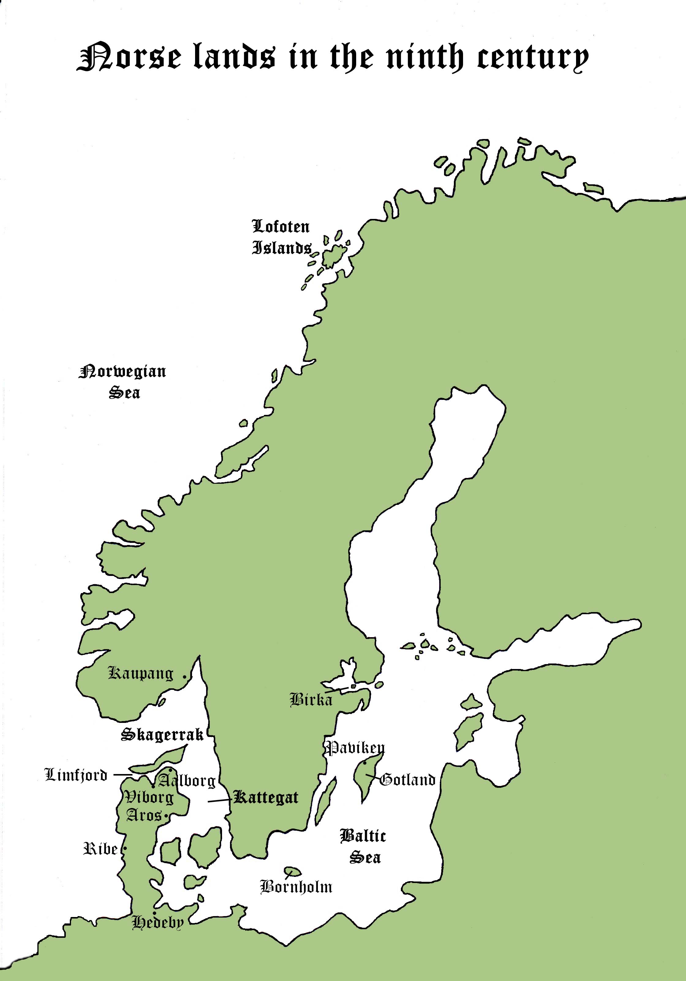
With more than a little help from one of my daughters, my two books now have two maps apiece. In Book 1, much of the action takes place in the various Norse/Viking lands, and I knew that few readers would know where most of the places were.
I chose to keep them as simple as possible and just pinpoint the key places visited in the stories.
These two maps are from Book One, Shadow of the Raven:

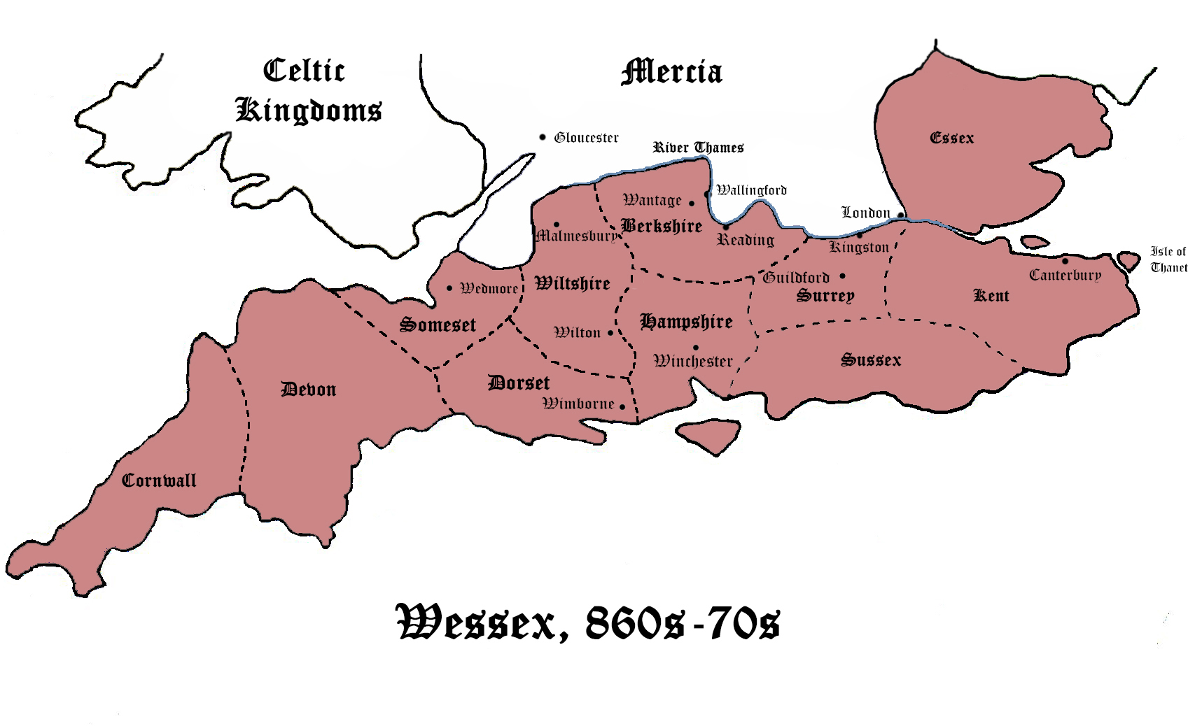
The next two are from Book Two, Pit of Vipers:
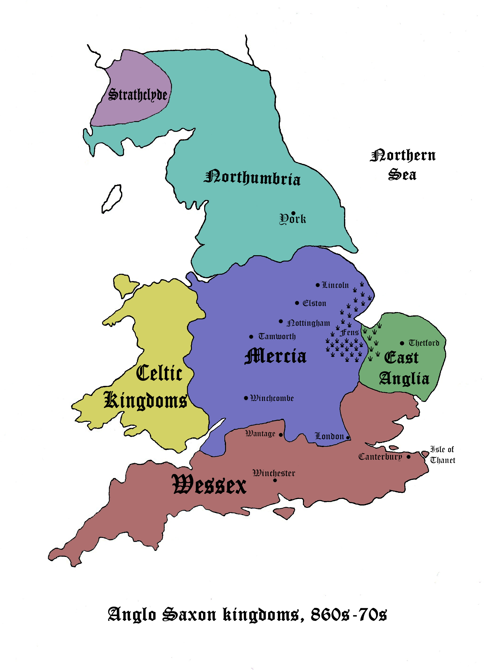
 I’ve deliberately made these maps very large to make them readable. On the Kindle they’re much smaller but, of course, they can easily be enlarged. Any comments or suggestions about them (preferably constructive!) would be gratefully received.

Excellent Maps—simple, clear, and elegant…
Thank you, Alexander. I was hoping that clarity wouldn’t be an issue. The print can be made quite large on a tablet /Kindle so is much easier to read.
Just curious, where would Ireland be in relation to this, and what relationship would that country have had in all this?
Ireland is west of the rest of Britain – west of Wales (labelled Celtic Kingdoms) on my maps, across what is now called The Irish Sea. Ireland doesn’t feature in my book because it was not an Anglo-Saxon kingdom. It was a Celtic land, often called Erin (Eire). The Norsemen – both Norwegians and Danes – did raid there, especially around the Dublin area, and, as with the Anglo-Saxon kingdoms, many eventually settled there.
Do some of your ancestors come from Ireland, Betty? It’s a lovely country. I’ve been a couple of times. It’s fresh and green – definitely ‘The Emerald Isle’. All that rain from across the Atlantic! Think of the East of Ireland sitting on the edge of my bog page (the white part, I mean). Not a very geographical description, but I can’t draw it on to show you! Haha.
Hope you’re not asleep after reading all that!
The little, unnamed island is the Isle of Man. Norwegian Vikings also settled there. From the top of the highest point on Man you can see both the UK and Ireland on a clear day. Now you’re definitely asleep, so I’ll go away!
No, actually, I’m quite interested! And yes, my ancestors did come from Ireland, some from England, but I haven’t traced them back that far yet. The Ireland folk are from Dublin and somewhere north, I can’t recall offhand. I’ll have to pull out my genealogy to get the name of the town and county. My maiden name is Chatham, though, which I’m told, is English. So I need to find that connection.
I found the maps on the Kindle useful, Millie, as in my mind I had Mercia in a different place and didn’t know that Wessex was so big either. Some say that maps in fantasy are cliche, but it is really hard for a reader to get a grip on a completely new world without them. And nuymber three is underway, I’m so pleased you have started. 🙂
I suppose I got there in the end with the maps. I agree, they are so important. Have you put some in your book? I know it’s fantasy. I’m looking forward to reading it in a couple of months. April’s not long off now!
It will have a map, maybe not a very good map! April is rapidly approaching, but hopefully I’ll be giving you a look about the end of March. Thanks for wanting to read it, Millie, appreciated.
I’m glad you’ll have a map as soon as your book is published, Christine. I left a bit late with my first book, as you know! I’m looking forward to reading your book, too! You must be getting excited now that April’s so close. 🙂
These are pretty cool maps. Can’t wait to use them with the books. 🙂
Thank you for saying they look ‘cool’. Louise did most of the finishing off on Photoshop – and she’s grinning like a Cheshire Cat now. She comes in handy at times! Hehe. And, of course, I can’t thank you enough for wanting to read ‘Shadow of the Raven’.
Nice! Nathan said he would write you a review too!
I don’t know what else to say, except thank you in multiple! I’d better hope you both like at least some of it, then. Now I will be worried . . . ! You are both stars! 🙂
I loved how you took the suggestions of your reviewers seriously and those maps looked fantastically cool! I’m sure they will love it!!! ❤ Great success on your books Millie! 😉
I’m glad you thought my maps were OK, Khloe. They were definitely needed in my books. I knew that few people – even some British people – would’nt know where the ‘kingdoms’ I was writing about actually were. I should have sorted my maps out a lot sooner! Very remiss of me! Thank you for your kind wishes – I really appreciate them. 🙂
You’re most welcome Millie ❤ Honestly, they were more than ok. They were fantastic 😉 Yep, I believe you should show them the maps in order to enrich their knowledge 😉
The maps are now at the front of the books on Amazon, so I just hope they do prove useful to readers. Thank you, again, Khloe.
You’re welcome 🙂 I’m sure they will find them useful 😉
Great maps! The simplicity allows one to see exactly where events are taking place without tons of geographical features and what-not cluttering it all up.
Of course, we Cornish would dispute the fact that we’re Anglo-Saxon or indeed English heh heh 🙂
I would have expected no other response from a Cornishman! It’s true that in Alfred’s time, Wessex control over Cornwall was very uncertain. It was based on a single, decisive battle in his grandfather, Egbert’s time. Many Cornishmen remained totally hostile to Wessex, refusing to acknowledge its domination, and when ‘The Great Heathen Army’ (mostly Danes) invaded in 865 many Cornishmen sided with the Danes! So, you’re right. Many, even perhaps most, Cornish people are probably of Celtic stock. Cornish place-names are a bit of a giveaway, too: Pen-y- whatsits everywhere! That was fun, writing all that! Thank you so much for the writing prompt, Ali! And, of course, for your kind comments about my maps.
A wonderful addition for your readers and I like the way you take in suggestions and act on them. I even find a map helpful in some modern day stories, such as the Nesbo thrillers, so when and if you visit the area written about, in the book, it comes alive!
I feel quite negligent in not doing the maps sooner. At least they’re done now, unless someone points out how they could be improved! I agree with what you say about some modern books needing maps, too. It does help us to visualise some scenes so much better. Street plans are particularly useful for that. Good to have your input on that. Thank you.
I like the maps and they are useful!! I’m a big fan of old maps anyway – many look so beautiful, if illustrated etc. (I’m going to buy an old world map and frame it on my wall one day, when we have a bigger apartment. I’d like the countries to be in Latin, maybe!) But in historical fiction it’s true that you really need them to follow the story 🙂
Maps are almost an obsession with me, too. I was a Geography teacher for too many years! Old maps satisfy my historical interest and, I agree, they can be very beautiful – and perfect framed for display on a wall.