A Visit to Murton Park Viking Village

287 Vikings 2

Last Saturday we had a great visit to the Murton Park Viking Village which is on the site of the Yorkshire Museum of Farming just outside of York. Although we took lots of photos of wonderful old farm machinery, this post is not about old farming methods on this occasion. Today I want to focus on Vikings!

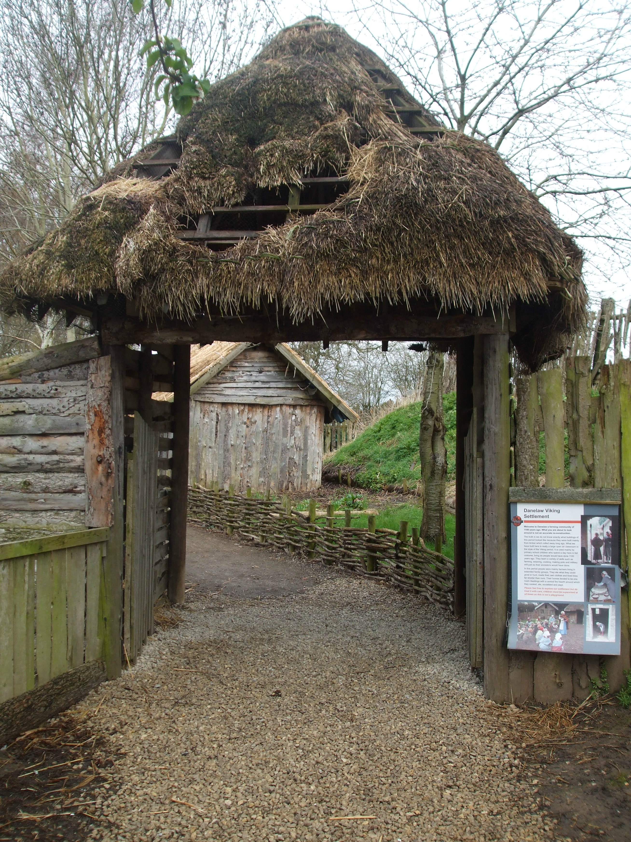
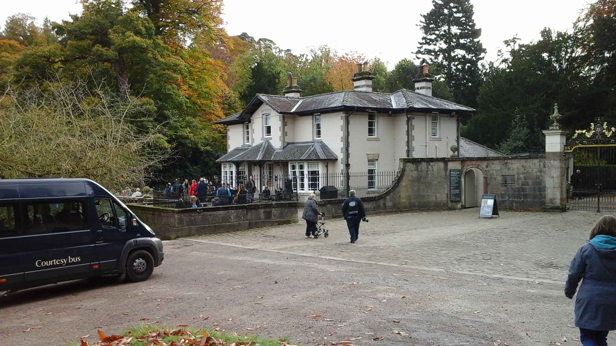
The reconstructed Viking village is excellent, and made specifically for the reenactment group who call themselves Jorfor’s Hall. I found out about them on Twitter (@jorforshall). The village is described as a Danelaw Farming Communityand over this particular weekend (9th and 10th April) the Vikings were in residence. This is the entrance into the village:

055 Entrance to Viking Village

And this is how the group describe themselves on their website, Jorfor’s Hall:

“Jorfor and his family are hunters and trappers, most of them originally hailing from the Troms area of northern Norway, though they have travelled far across the Viking world, some further than others, and settled in many different lands”.

The group takes part in Viking events all over the country, as well as featuring regularly at Murton Park. Events are tailored for a variety of needs including school parties, youth clubs, fairs, fetes and shows. They also take part at the Jorvik Viking Festival in York in February.

The weather on Saturday morning was a bit dreary to start with, and it was very wet underfoot, but that only served to illustrate the conditions people would have lived with 1100 years ago. Most of the pathways through the settlement were wood-planked, to counteract the mud. This tallies with what I found when doing my research several years ago about the Danish trading town of Hedeby. 

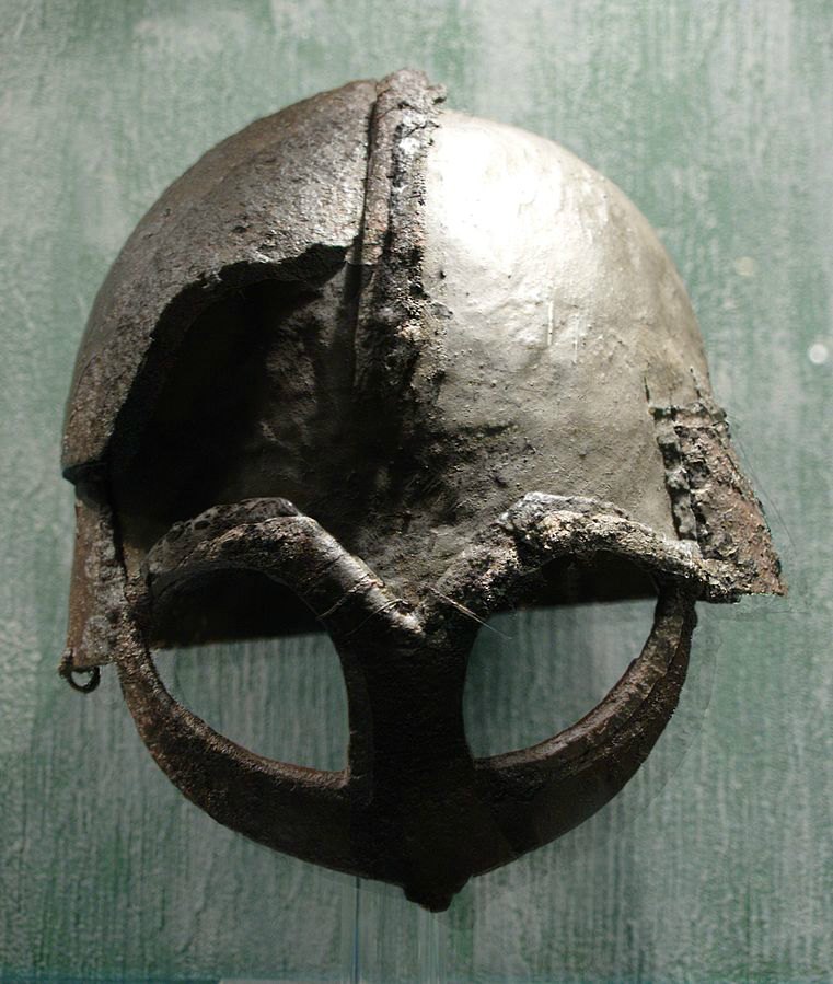
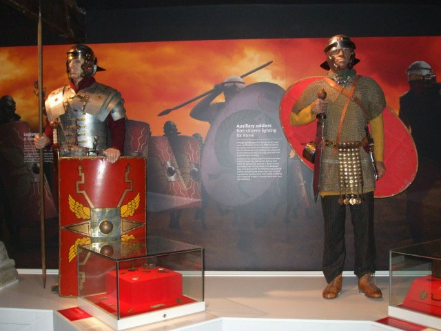
This was the man in charge, the chieftain of the village, wth the very appropriate name of Bear. Thankfully, he was a very friendly bear and told us a lot about the great helmet he’s wearing or holding in these photos, as well as how it compares in battle to the one on the stool.

I’d run a mile fast if I saw someone coming at me wearing a helmet like that – and that, according to Bear, was exactly what the helmet was supposed to do: terrify people (especially when the man wearing it was as big as Bear!). The helmet, however, was not the typical Viking style; the more usual design being like the one with a nose guard, shown on the stool. Bear’s helmet is a replica of a famous one discovered in Norway. I think (but I’m not sure) Bear said it was the one found in a 10th century chieftain’s grave at Gjermundbu.

I found this picture of it on Wikimedia Commons.

Viking helmet from Gjermundbufunnet, now at Kulturhistorisk museum. Author: J Jeblad. Creative Commons
Viking helmet from Gjermundbufunnet, now at Kulturhistorisk museum. Author: J
Jeblad. Creative Commons

However, Bear did say that this helmet could be one that had been brought back from the East (trade or raid) and the style was not adopted for long amongst the Vikings. Although the facial shield and eye mask are intimidating to say the least, they could be disastrous in battle. A sword thrust into an eye socket would  direct the sword straight into the eye! With the more usual nose guard, there was the possibility of the sword being deflected away from the eye.

The village itself displays a variety of housing styles and shop fronts, generally from the 9th and I0th centuries. But, as it says on the information poster at the entrance, no one knows for certain what buildings looked like. They were all made of timber, which rots away leaving little evidence. Roofing materials in the village vary from thatch to split tree trunks, wood planks and shingles and some of the buildings are decorated with colourful designs and some some have little gardens:

Inside these houses, space was limited and indoor life continued around the ever-present central hearth fire. Every home would have a loom, where women would make clothes, blankets and wall hangings. Storage chests did what storage chests usually do. 🙂

To finish with, these are a few of the villagers themselves, some about their work, others just cooking or socialising. Jobs and trades around the village would be many and varied, and of course, warriors would always be on the alert in case of attack.

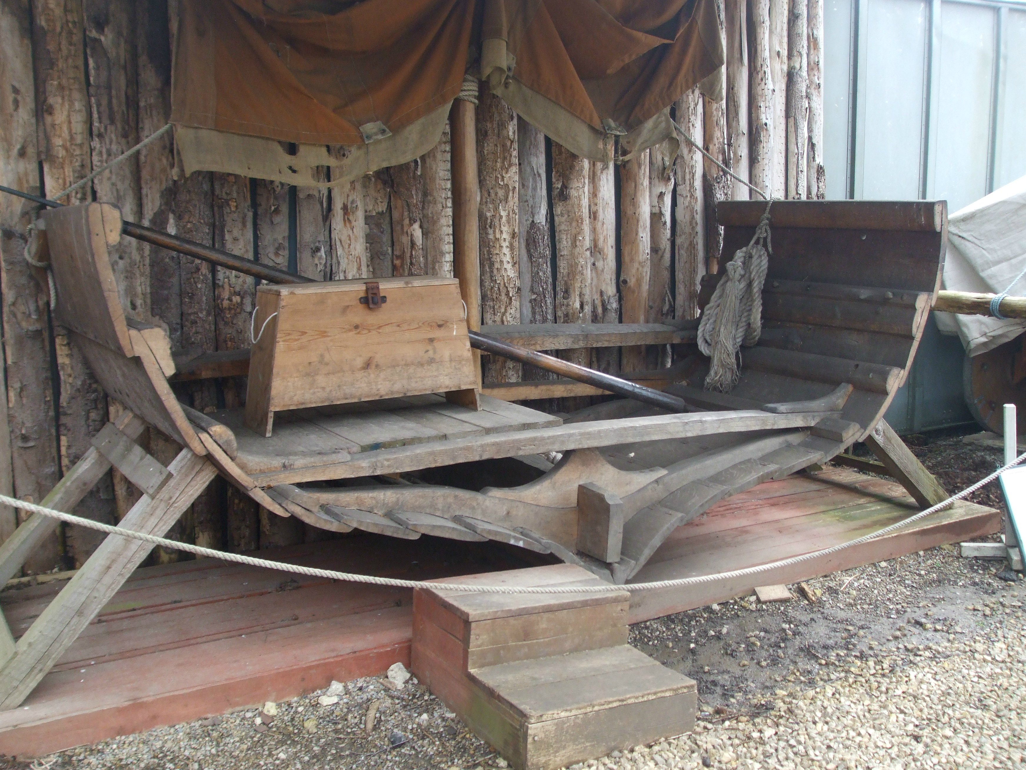
. . . and the cross section through the hull of a reconstructed Viking ship that greets visitors on the way in. It shows how Viking ships were built using overlapping wooden planks (known as clinker planking) which made them waterproof. This technique is still used today in wooden ship construction. It was donated by the Yorkshire Museum.

057 Viking ship reconstruction

Mother Shipton’s Cave

096 Entrance 3

I’ve been away in York for the past five days, during which time we visited several interesting sites. We decided to go to York initially to visit a Viking Village at Murton on Saturday, but we managed to fill the rest of the days very nicely, too. I must apologise for not visiting blogs at this time, as the internet connection in the hotel was more off than on. I hope to get to as many as I can in the next few days.

Anyway, the Mother Shipton site was the first one we visited and here’s some information about it.

Mother Shipton’s Cave – a site which also includes the Petrifying Well – has been England’s oldest visitor attraction since 1630. It’s located in the historic market town of Knaresborough, four miles east of Harrogate, in North Yorkshire, UK.

Knaresborough
Map of North Yorkshire, UK. Author Nilfanion, created using O.S. data. Creative Commons.

The actual cave was home to England’s most famous clairvoyant and prophetess – Mother Shipton herself:

063 Mother Shipton in her cave
Sculpture of Mother Shipton in her cave

This famous attraction sits in unspoilt parkland, a remnant of the once extensive Royal Forest of Knaresborough. The park lies along the banks of the River Nidd, which at this stage, flows through a gorge created by a glacier during the last Ice Age, 12 000 years ago.

There are many lovely views across the river. Some simply look over to the buildings of the town, others to the gorge and Knaresborough Castle sitting atop it. And across an impressive, roaring weir is the old mill, aptly known as Castle Mill. There are also great views of the viaduct carrying the railway, and the lower (in height) bridge known at the High Bridge.

As our visit was during the Easter holidays, a special children’s event was running, this one with the theme of Alice in Wonderland. It involved some of the staff dressing up in costumes, such as the Queen of Hearts, the Mad Hatter and White Rabbit. Children seemed to be enjoying the fun:

Both Mother Shipton’s Cave and the Petrifying Well are natural geological features which can be found close to each other on the site. The latter never fails to fascinate visitors from near and far. It was first opened to the general public in 1630:

Any object left in this well for a period of months/years becomes ‘stony’ on the exterior. It’s a natural phenomenon, due to the evaporation of water with a high mineral content. Nowadays, objects from various ‘celebrities’ have been left to undergo transformation. But at one time, these strange occurrences at the Petrifying Well were believed to be the result of magic or witchcraft. People believed if they just touched the water they would be turned into stone.

So, just who was Mother Shipton . . . ?

Mother Shipton was born on a stormy night in 1488, with the name of Ursula Southeil. Her fifteen-year-old mother, Agatha, gave birth in the cave after being banished for refusing to reveal the name of the father of her unborn child. After two years of a struggling to survive in the cave, the fate of the mother and child became known to the Abbot of Beverley, who decided to help them.  Little Ursula was taken into the home of a local family, but her mother was sent to a convent in Nottinghamshire, here she died two years later.

As a child, Ursula grew to love Knaresborough and often played along the banks of the Nidd. At school she far surpassed other children at reading and writing, but her looks were what most people saw as ugly. The other children taunted her and ridiculed her long, crooked nose, bent back and twisted legs. They even claimed she took her revenge, and could feel her by pulling their hair and pushing them to the ground – when she was nowhere near.

Mother Shipton 2
Old engraving of Mother Shipton. Author Unknown. Public Domain.

Ursula soon realised that she much preferred to be on her own, and came to spend most of her time in the cave. Despite having no memory of having lived there, she claimed it drew her back. She learnt much about the forest, its plants and herbs, and how to make cures for ailments and various potions. She also discovered, she was able to predict the future, and her prophecies are what she became famous for.

At twenty four, Ursula  met and married Thomas Shipton, a carpenter from York. For two years they were very happy, but Thomas died young – before any children had been born. But Ursula kept the name of Shipton, and as she aged, the title of ‘Mother’ was added to it. She died in 1561 at the age of seventy three, but her prophecies lived on . . .

Mother Shipton made many prophecies, several about people who lived during or just after her own lifetime. She predicted the end of the Catholic Church in England under Henry VIII and the fall of Cardinal Wolsey. She also foretold the death of Henry’s son, Edward VI, the ‘bloody’ events of Mary’s reign and that her sister, Elizabeth, would take the throne. Mother Shipton also foretold the coming of the Spanish Armada and, according to the diary of Samuel Pepys, the Great Fire of London in 1666.

Other predictions relate to later times, including the coming of iron ships (in the 1830s). There are dozens of these prophecies, which can easily be found online. But we need to bear in mind that many people believe them to be fake – like this one, which did not appear until 1862:

The world to an end shall come
In eighteen hundred and eighty one.

Its true author, Charles Hindley, later admitted in print that he had invented it.

In the 17th century, when witch hysteria hit England, the image of Mother Shipton gradually changed from prophetess to witch. She became known as one of England’s most renowned witches. This moth – known as the Mother Shipton Moth – got its name because of the markings on its wings, which resemble an old hag’s head. They are common over much of the British Isles, and can be seen in May and June in the woods around Mother Shipton’s Cave:

Mother Shipton Moth 2
Mother Shipton Moth, named after the pattern on the wings resembling the face of a hag. Author Callistege – mi_02 (xndr). User: Sydmolen. Creative Commons.

Hadrian’s Wall (2) – Vindolanda

031 Helmet plume from Vindolanda, how in The Roman Army Museum

Vindolanda is my favourite site to visit when we go up to Hadrian’s Wall. It has everything a history lover could want: ancient ruins to walk around – with an ongoing archaeological ‘dig’ during the summer months – and reconstructions of parts of Hadrian’s Wall. There is also an excellent, award-winning museum housing many of the finds from the dig. The scenery around the site and the landscaped gardens and little stream close to the museum are a delight in themselves.

Vindolanda was the longest occupied fort along the Roman northern frontier, built between AD74 and 85 and continuing through to end of Roman Britain in AD410. It is sited pretty much centrally between the eastern  and western ends of the Wall but is not on Hadrian’s Wall itself, being a mile or so to the south of it. These maps aren’t that clear, but they may give some idea of location:

Route of the Stanegate Road.
Route of the Stanegate Road. Author: Neddysegoon. Creative Commons
Approximate location of Vindolanda
The x marks the approximate location of Vindolanda. The photo is of an information board at Housesteads fort.

The fort, and the settlement that grew up with it, were first constructed four decades before Hadrian decided to build his wall. It formed part of a line of a few forts along the Roman road known as the Stanegate (Stone Gate). By the time the building of Hadrian’s Wall began around AD122 there had already been four forts and towns on the site (wood rots!).

At its height, Vindolanda would have supported a population of 3-4000, of which 1000 would have been largely auxilliary soldiers. The rest was made up of the soldiers’ families, traders and merchants, servant and slaves. People from all over the Roman empire would have lived here: from North Africa, Spain, Syria, France (Gaul/Gallia) and Germany and Italy itself. Hence there would be a great variety of customs, diets, dress and dialects.

395 Map - Roman Empire (2)

While Hadrian’s Wall was under construction, Vindolanda became a sort of ‘base camp’ for the legionaries and many workers involved. Once the Wall was completed, Vindolanda formed part of the Wall garrison, despite being a mile south of the actual Wall.

But the population of Vindolanda was always on the move, shifting from one ‘posting’ to the next, and the majority of the people would have gone with them. At one point, between AD280-304/5, the site was abandoned and lay derelict, and was rebuilt in AD305. Excavations have unearthed remains of a large bonfire on the site. It had been used to destroy all the household goods of the prefect/commanding officer at that time as his household prepared to move on to another site. At he bottom of the huge pile of remains, many letters and other communications had survived: wonderful archaeological evidence of life up on the Wall at that time.

All this construction and rebuilding work meant that in places it has been necessary for archaeologists to dig down as much as 7 metres below the original ground level to reach many of the ‘finds’.  But the constant renewal of the site also helped to create the excellent preservation conditions (anaerobic/anoxic levels) where there is little or no oxygen.

Photo of excavation work at Vindolanda from a display board inside the museum.

The ruins need to be viewed in two parts. First there is the fort. Although there is still a lot of it to be excavated, some buildings are clearly identifiable. Most of the outer walls and gates are visible, as well as both the NE and SW corners and a latrine. As all Roman forts, this one had the typical playing-card shape (rectangular with rounded corners). It also had the three central and most important buildings of every fort: the headquarters building; the commanding officer’s/prefect’s house and the granaries. Then there were the other usual buildings such as the soldiers’ barracks, latrines and so on. I don’t intend to describe all these here because my next post is about a single fort (Housesteads) and I’ll be talking about that then.

What I’d like to focus on now is the vicus at Vindolanda  – the settlement that grew up outside the walls of the fort.

066 Model of Fort and Vicus on Entering Vindolanda
Model of the fort and vicus at Vindolanda in the entrance to the site.
Plan of Vicus at Vindolanda

The present day ruins are quite incredible and give us plenty of insight into everyday life in a Roman settlement at this time.  I couldn’t possibly describe all of the different remains in a single post but they included everything from temples and mausolea, shops of various types, a tavern and workshops to a military bath house, wells and water tanks.

Finds from the dig have produced the most important archaeological discovery of the last 50 years: the writing tablets. They are currently housed in the museum – on loan from the British Museum in London – and displayed in an hermetically sealed case, protected from the decaying effects of oxygen, moisture and humidity.

The first writing tablet from Vindolanda was unearthed over 30 years ago. It was one of the most important archaeological discoveries in Britain since 1945. The collection of about 2,000 documents is an invaluable source of information about life in the Roman army on the northern frontiers during the years immediately before the building of Hadrian’s Wall. The tablet I always loved is one from Claudia Severa to Sulpicia Lepidina, the wife of the garrison’s commanding officer in AD100, inviting her to her birthday party. But the largest tablet is a four page one from Octavius to Candidus, listing business transactions between Vidolanda and Catterick Roman fort in Yorkshire, roughly 68 miles away. It contains the amusing phrase ‘the roads are awful’!

Other ‘finds’ from the dig include armour, shoes, socks, wigs, wood and leather items, textiles, glass, pottery, ironwork, inscriptions and sculpture. One of the most impressive finds is the hair-moss crest from a helmet, now housed at the Roman Army Museum at Carvoran, where we photographed it. That museum is also run by the Vindolanda Trust (so, unlike some of the other sites along the Wall, these two are not run by English Heritage or National Trust).

031 Helmet plume from Vindolanda, how in The Roman Army Museum

This was made from a type of moss that grows nearby, simply referred to as ‘hair moss’. It is believed these crests would have been in several colours, but the only one I found on Wikipedia was red:

Reconstruction of a centurion helmet with crest made of hair moss. Photographed from a show of Legio XV from Pram, Austria, No details about author. Creative Commons

Here’s a selection of other finds on display at Vindolanda. Most were displayed behind glass and in bright lights …sorry about the glare:

To finish with here a a few photos of the Temple to the Water Nymphs and a couple of altar stones outside . . .

. . . and some photos from inside the reconstructed house and shop nearby:

Following the Roman period the Vindolanda site was of little importance to anyone other than farmers and those needing stone to build their houses. Odd artefacts turned up occasionally, but the reality of what lay beneath the soil remained a mystery. When more and more finds were made, in 1832, the Reverend Anthony Hedley built his new house on the site and called it Chesterholm. The house is now an integral part of the museum. He also made the first real steps in preserving the site.

Yet it wasn’t until 1929 when young scholar, Eric Birley, bought the property that the amazing potential of Vindolanda came to light. He ran the first series of excavations, but the Second World War put a halt on things for a while. After the war, excavations continued, and the site stayed in the hands of the Birley family until 1970 when Eric’s son, Robin, handed it over to the Vindolanda Trust on behalf of the nation.

I haven’t done credit to the Birley family here as this post is rapidly becoming a book! But if you visit Vindolanda during the summer, you may catch a glimpse of one or the other of this awesome family, still happily digging away.

437 Wooden and stone turrets at Vindolanda

A Visit to Hadrian’s Wall

186 Walltown Crags (2)

Last August, Nick and I spent some time up in the North of England in order to visit one of my all-time favourite sites . . . Hadrian’s Wall. I’m totally smitten by this structure and the wonderful, open scenery around it, but I can well imagine what the Romans felt about manning it, particularly in the cold, wet, or icy winter months. It really is quite desolate up there, with nothing to see for miles other than the odd farm and plenty of sheep.


Sheep around Hadrian's Wall

We took lots of photos of the various forts and museums, as well as several of the Wall itself. I thought I’d do the first post about Hadrian’s Wall in general and follow it with a couple about the forts we visited along its route. To start with, here’s some information about the Roman Invasion and the building of the Wall:

The Romans first invaded Britain in 55 BC under Julius Caesar, but this was not a success, and permanent occupation of the island only began in AD 43 when the Emperor Claudius launched an invasion…

Statue of Claudius in the Vatican Museum. Author: sailko. Creative Commons

Even then, the invasion was not as easy as Claudius had hoped. The Celtic tribes were savage  and warlike and most had no intention of succumbing to Roman domination. Some did, of course, including the Brigantes – whose queen, Cartimandua, I mentioned in my Chester post. It was only once the Boudicca uprising of AD 60-61 had been quelled that the Romans were able to move out and establish control over the rest of the country.

The fort of Roman Chester (Deva) was established by AD 70. The great fortress at York, Eboracum – which became the provincial capital of ‘the North’ – was also founded at this time, and shortly after AD 100 the most northerly army forts stretched between the Tyne and the Solway. These were linked by a road now known as the Stanegate, which provided good communications between Corbridge towards the east and Carlisle in the west. It was along this line that, in AD 122, the Emperor Hadrian ordered the construction of the Wall.

Hadrian

Hadrian’s Wall is the most important monument built by the Romans in Britain. For 300 years it was the north-west frontier of the Roman Empire. According to Hadrian’s biographer, it was intended to separate Romans from the barbarians further north. But in many ways, the Wall is the recognition of Rome’s abandonment of its intentions to conquer all of Britain. Having originally intending to conquer further north the Romans had now become more interested in controlling goods in and out of their empire and focused on their frontiers.

Location of Hadrian's Wall and the Antonine Wall. Author: NormanEinstein. Creative Commons
Location of Hadrian’s Wall and the Antonine Wall. Author: NormanEinstein. Creative Commons

Hadrian’s Wall stretched for 73 miles (80 Roman miles) across country, from Bowness-on-Solway in the west to Wallsend-on-Tyne in the east, and forts were located about every five Roman miles. It followed the natural contours of the Whin Sill Ridge:

0551 Whin Sill

It was built by the soldiers themselves, mostly the legionaries:

Legionaries building The Wall
Legionaries building the Wall. Photo from Housesteads Visitor Centre.

The Wall is thought to have been up to 3.1 meters thick and about 4-5 meters high. At the top was probably a protected walkway for soldiers on patrol. At first, it was built either of stone or, in the western third, of turf and timber and replaced by stone after 30 years.

Milecastles were  gateways, placed at every mile between the forts, as legal crossing points:

The remains of Castle Nick, Milecastle Milecastle 39, between Housestaeds and Onve Brewed Visitor Centre for Northumberland. Author: Adam Cuerden. Public Domain. Wikimedia Commons
The remains of Castle Nick, Milecastle Milecastle 39, between Housestaeds and Once Brewed Visitor Centre for Northumberland. Author: Adam Cuerden. Public Domain. Wikimedia Commons

Turrets, or small watch towers, were built into the wall at intervals of a third of a Roman mile (equivalent to 541 yards) i.e. two turrets between each milecastle. The reconstructions below are from Vindolanda (the site of one of the forts along the Stanegate road, already in existence before the Wall was built.):

087 Wooden milecastle
Wooden turret at Vindolanda
086 Stone turret
Stone turret at Vindolanda

Below is a reconstruction of a Roman soldier on watch over the Wall – probably at one of the milecastles or turrets. It wasn’t the most pleasant of jobs during the cold northern winters – especially for soldiers used to Mediterranean climes.

011 Soldier on the Wall (2)

During the building of the Wall, it was decided to build an additional 12 or 13 forts actually on the wall line. South of the Wall, a great earthwork known as the Vallum was completed. This consisted of a ditch with a mound set back on either side stretching the length of the frontier from the Tyne to the Solway. Crossings through the Vallum were only at the forts. There was also a ditch on the northern side, except in places where the high ridge or the Solway coast made it unnecessary. Material from this ditch was used to make an outer band on the north side.

Cross section of the works. Author: Ujap.de. Creative Commons
Cross section of Hadrian’s Wall. Author: Ujap.de. Creative Commons
Vallum at Hadrian's Wall. Photographer: Optimist on the run. Creative Commons.
Vallum at Hadrian’s Wall. Photographer: Optimist on the run. Creative Commons.

Soldiers from three legions of Britain (Legionaries) came north to build the Wall, with soldiers from the provincial army (Auxilliaries) and even sailors from the fleet to help. In the ‘overbright’ picture below from The Roman Army Museum, the Auxilliary soldier is the one with the oval-shaped shield:

Legionary and Auxilliary

It took them over ten years to complete. But on Hadrian’s death in AD 138, his wall was abandoned on the orders of the new emporer, Antoninus Pius, who ordered the building of a new wall almost 100 miles further north, acoss what is now known as the Central valley of Scotland. It stretched for 37 miles, from the Forth to the Clyde estuaries and, unsurprisingly, became known as the Antonine Wall. After 20 years, it was abandoned in favour of a return to Hadrian’s Wall.

Outside of the forts, civil settlements (vicus) became established, where the soldiers’ families lived. There were also shops and inns in these settlements, seeking to make a living from the soldiers, who were relatively well paid compared to the farmers of the frontier region. l’ll say more about these settlements in my next two posts.

Since the Roman withdrawal from Britain in AD 410, Hadrian’s Wall has gradually reduced in size due to local people plundering the stones, for a variety of purposes. Many churches, farms and field walls, as well as several castles contain stones originally found in the Wall. Plundering continued until the 19th century when archaeological excavations began and interest in the preservation of heritage sites took on an importance. The agricultural revolution of the 18th century also led to further destruction of the Wall as the land was cultivated. Today, although the actual Wall has disappeared in places, it survives in place-names such as Wallsend, Heddon-on-the-Wall and Walton – amongst several others.

I have visited most of the forts along the Wall, as well as The Roman Army Museum at Carvoran. There are several sites I really like, but intend to do posts only about a couple of them. Each site has something different to offer. To finish with, here’s a photo of a Roman Legionary we met at Birdoswald Roman Fort. He was very chatty and friendly and put on his special scowl just ‘for the camera’:

015 Bird Oswald Soldier (1)

A Look at Roman Chester

Plan of fort and location of ampitheatre

Last June we had a few days in Chester, mostly to visit my aunt and uncle in North Wales but also to visit some of the castles along the North Wales coast. We managed to do all that, and I posted three ‘castle posts’ once we got home, as well as one about Bodnant Gardens. We were staying at a hotel in Chester, so we also spent one of our days in the city – but I never did get around to posting about it. So today I’ve duly written it up.

Chester is located in the county of Cheshire in the north-west of England, south of the River Mersey and the much larger city of Liverpool. The River Dee flows through it in its way to the Irish Sea:

Map of Cheshire showing location of Chester. Source: Ordnance Survey OpenData. Author: Nilfanion, Creative Commons

Chester’s a lovely old city, with evidence of settlement throughout various periods since Roman times. The town centre is known for its many ‘black and white’ buildings and galleried shops, or the ‘Chester Rows’.

Bridge Street, Chester (2)
Bridge Street, Chester.  Author: Crashlanded. Creative Commons

There is a lot about this city I could talk about – including the Anglo-Saxon period and the medieval castle and city walls . . .

Chester's City Walls -Bridgegate to Eastgate (2)
Chester’s City Walls – Bridgegate to Eastgate, Source: geog.org.uk. Author: John S. Turner. Creative Commons

In the ‘Dewa’ Roman museum, there are cellar remains showing settlement at various levels/strata – through Roman, Saxon and later medieval periods. Buildings around the city also provide evidence for these periods, as well as later times.

Cellar remains showing levels of settlement at Dewa Museum

But today I want to focus on the Roman settlement at Chester (Deva or Dewa).

Dewa/Deva stood on a ridge of red sandstone in a loop of the River Dee. This photo shows a ‘cut’ through the ridge for the Chester – or Shropshire Union – Canal:

Triassic Sandstone along canal

The settlement began life as a mostly wooden fortress built by the Second Legion, Adiutrix, in AD 70, and was named after the local name for the goddess of the river, Dewa. The site was perfect for several reasons. It controlled the newly occupied and hostile areas of the Welsh as well as those of Northern Britain, and the River Dee was navigable up to the sandstone ridge, providing good harbour facilities and good protection on the southern and westerly sides. It is also possible that the fortress was intended as a supply base and embarkation point for the intended conquest of Ireland.

At the end of the 80s, the 2nd Legion was sent to Germany and the Twentieth Legion, Valeria Victrix, moved into the fortress:

Moulded antefix roof tile showing badge and standard of the Lefion XX - from Holt, Clwed, Wales. Author: AgTigress. Creative Commons
Moulded antefix roof tile showing badge and standard of the Legion XX – from Holt, Clwyd, Wales. Author: AgTigress. Creative Commons

The Twentieth replaced the wooden buildings with stone and stayed in the fortress until the 5th century.

Remains of a wooden jetty have also been found. Exports would have included tin, silver, hides, oysters, wooden products, basketry, slaves and hunting dogs. Despite Britain’s mineral wealth, Rome gained little from the country and needed to import far more goods in order to meet the demands of the Roman soldiers stationed here. According to the Roman writer, Strabo, imports included ivory, amber, gems, glass vessels, wine, olives and olive oil, figs, pottery, papyrus and spices.

Here are some photos of some of the artefacts, plus a few replicas, of Roman items we saw on display at the Dewa Roman Museum:

Deva had the typical ‘playing card’ design of all Roman forts. The outer edge was a tall, thick stone wall, five courses high, and with four gatehouses to enter:

Plan of fort and location of ampitheatre

Outside the fortress wall, as well as the civilian settlement (canabae/vicus) were a bath house and an amphitheatre. Evidence of the amphitheatre was first discovered in 1929 but it wasn’t until 1993 that excavation work started on it. To date only half of it has been excavated. It is thought to have been the biggest amphitheatre in Britain and seated 7,000 spectators. There were four entrances, the main one being on the northern side.

Model of ampitheatre

A small room at the east entrance may have held the beasts – which would most likely have included stags, bulls and bears, not the lions and elephants etc seen in Rome.

The entrance to the passageway shown is thought to have led to area where the beasts were held
The entrance to the passageway shown is thought to have led to the area where the beasts were held

A shrine to the goddess, Nemesis, was discovered beside the north entrance and an altar dedicated to the centurion, Sextius Marciano. The walls of the arena were painted a reddish brown to give a marbled effect and the arena floor was covered in yellow sand to stop combatants from slipping. It could also be easily cleaned.

Gladiator fights were popular and aroused great passions. Gladiators were often prisoners of war or condemned slaves reprieved from execution and specially trained. Combat gave them a chance to win a ‘new life’ by showing skill and courage. The killing of beasts would have reinforced the belief in man’s dominion over nature – important in a world in which wild animals still posed a real threat.

Gladiator info.

Gladiator fights

All in all, Chester is well worth a visit. Many tourists also come to see Chester Cathedral, too, which belongs to the later medieval period. Built of the local red Triassic sandstone it was opened in 1541.

Here are some photos of the cathedral to finish with:

Blackpool Out of Season


Blackpool Promenade looking south (2)

Last week I wrote a post about our day out to the pine woods and sand dunes at Formby, a few miles down the coast from my hometown of Southport. It was fantastic for me to be by the sea again. I can’t tell you how much I miss it…

The following day, we decided to be totally reckless and head off to Blackpool:

Location map of Blackpool (2)
Map of Lancashire with Blackpool highlighted. Source: OS Survey OpenData. Author: Nilfanion. Creative Commons.

I don’t mean any disrespect to the town in saying that, it’s just that in February many seaside towns are notoriously ‘dead’ and, on this occasion, Blackpool proved to be no exception.

Here are a few photos of the Promenade as we walked along it. Admittedly the absence of sunshine didn’t help . . .

Like most seaside towns around Britain, Blackpool’s heyday has been and gone. The 1950s and 60s saw these towns thriving – until a mix of factors, including cheaper air fares, longer holidays, higher pay etcetera – led to the great increase in Brits heading abroad in the following decades, mostly to Spain and other Mediterranean countries. The British seaside towns saw a gradual decline, many looking very sorry for themselves and sadly neglected. (But it’s good to see that many are now undergoing a ‘rejuvenation process’.)

Blackpool got its name from a historic drainage channel called Spen Dyke, which ran over a peat bog. Blackened water was discharged into the Irish Sea, forming a black pool on the other side of the sea. Dublin (or Dubh Linn) comes from the Irish name for ‘black pool’.

The area behind the town, known as the Fylde, was once inhabited by a Celtic tribe called the Setantii, a sub tribe of the Brigantes (whose most famous queen was Cartimandua, who stayed loyal to the Romans at the time of the Boudica rebellion).

Cartimandua delivering Caractcus to the Romans
Caractacus, King of the Silures, being delivered to the Roman general, Ostorius, by Cartimandua. Author: Francesco Bartolozzi (publisher, printer: 1728-1815). Public Domain

The area developed very slowly for hundreds of years, some of the small, coastal villages eventually becoming part of Blackpool. But it wasn’t until the 18th century, when the practice of sea bathing to cure diseases became fashionable with the wealthier classes, that Blackpool really began to grow.

By 1781 a private road was built to the town and a regular stagecoach service to Manchester and Halifax started. A few amenities, hotels, an archery stall and a bowling green developed – and the town steadily grew By 1801, the population was 473. But the most important factor in Blackpool’s early growth was the arrival of the railways. By 1851 the population had reached 2,500.

With the sudden increase of visitors came the need for more accommodation, and more attractions. Gas lighting was introduced in 1852 and piped water in 1854.

By this time, the Lancashire cotton industry was thriving and it became the practice among mill owners to close for one week a year for servicing and repairing machines. Many mill workers would stream into Blackpool. Fortunately, each mill closed for a different week, enabling the town to keep a steady flow of visitors throughout the summer.

Between 1863 and 1893, three piers were constructed out over the sea (North, Central and South Piers) – and Blackpool proudly became the only town in Britain with three piers.

Blackpool North Pier opening. Author: Mr. W. Woods of Liverpool, 1863. Public Domain

The Winter Gardens (a larger entertainment complex including a variety of venues, including a theatre and ballroom and conference facilities) was opened in 1878.

1024px-BlackpoolWinGar

And the town’s most famous building, the Blackpool Tower, was first opened to the public in 1894.

800px-Blackpool_Tower_general_view
Blackpool Tower, general view. Author: http://www.flickr.com/photos/ingythewingy/ Creative Commons

Inspired by the famous Eiffel Tower in Paris, Blackpool Tower was built at a total cost of £290,000 (for design and construction). It is now a Grade 1 listed building. It houses several attractions, including the famous Blackpool Tower Circus and equally famous ballroom:

Jazz event in the Tower Ballroom. Author Lukasz Nurczynski. Creative Commons

At 518 feet high, it is the 103rd tallest freestanding building in the world. On clear days it can be seen from as far away as North Wales and the Lake District. At the summit is a flagpole and buried beneath the foundations is a time capsule. How exciting! (No, I’m not being sarky.) The picture below is looking south from the top of the Tower.  The Central and South Piers can be seen.

Blackpool's ' Golden Mile' viewed from the top of the Tower. From geog.org.uk. Author: Mike Hartley. Creative Commons
Blackpool’s ‘ Golden Mile’ viewed from the top of the Tower. From geog.org.uk. Author: Mike Hartley. Creative Commons

Two years after the Tower was completed, the Pleasure Beach (amusement park/fairground) was founded and has become one of the most visited tourist attractions in the UK and one of the top twenty most visited amusement parks.

Blackpool 'Pleasure Beach'. Author Gambitek. Creative Commons
Blackpool ‘Pleasure Beach’. Author Gambitek. Creative Commons

It holds the record for having the most roller coasters in Europe. Of the ten it has, five are wooden.

In 1897, Blackpool became the first municipality in the world to have electric street lighting as long stretches of the Promenade were wired. This lighting, and the accompanying pageants, played a big part in the development of the Blackpool illuminations in the autumn – a Lights Festival which runs for around 60 days.

Illuminated Trawler at Blackpool. Author Mark Jobling. Public Domain

Blackpool has seen many changes in fortune over the years, but it still has the reputation of being one of the UK’s most well known seaside resorts. The following picture (which is looking north) shows what the Promenade was like in 1898:

Blackpool Promenade c 1898. Author Detroit Publishing Co. under license from Photoglob Zurich. Public Domain

Today, Blackpool manages to maintain a steady stream of holidaymakers and day trippers during the summer, and the town still has a thriving tram route, which runs from Starr Gate to the south of the town to the fishing port of Fleetwood to the north – a distance of 9.9 miles:

Tram at Tower tram stop. Author: Chris Wharton. Creative Commons

Large numbers of people visit the illuminations every year. In 2016 they will be ‘on’ from September 2nd until November 6th (66 days). As a child, my parents took us to see the illuminations on several occasions, and I found the lights, the Disney characters and all the other features totally magical.

Blackpool Illuminations and Tower. Author: Mark S. Jobling. Public Domain

References: a variety of Wikipedia pages (for images other than my own, plus additional historical detail).

Formby Point in February

037 View to the SeaFor the past few weeks I’ve been attempting to get on with my writing and for the most part, have succeeded in doing that. I still have some distance to go before I finish Book 3, but it’s coming along reasonably well. Unfortunately, last week, we needed to visit my 87-year-old aunt in Carnforth (north Lancashire) who has been unwell recently, so my writing was again ‘on hold’.

On one of the days we were there, we managed a run out to my hometown of Southport – a Victorian seaside town on the north-west coast of England.

Map of Merseyside, UK. Source Ordnance Survey Open Data. Author Nilfanion. Creative Commons.

Southport has had its ups and downs over the years, particularly since losing its place in Lancashire and becoming part of Mersyside in the early 1970s. I intend to write a post about the town at some stage, as I’ve always loved it and often long to be back there. Many golfers from around the world will know this coastal region for its famous links golf courses, including Royal Birkdale, Hillside and Ainsdale.

On this occasion we first drove a little further down the coast to Formby Point, and I thought I’d share some photos of the sand dunes and pine woods there. This whole area of coastline is managed as a Special Area of Conservation (SAC). Parts of the stretch, at Ainsdale, a litttle closer to Southport than Formby, have been a Nature Reserve for many years now – even when I lived there in the 1950s and 60s. The Reserve is the habitat of the Great Crested Newt, Britain’s most protected species of amphibian. I believe its numbers are now on the increase at the Reserve.

My sister and I often used to cycle down to the pine woods with a picnic when we were teenagers, and it hasn’t changed a lot since then – except that Formby Point is now managed by the National Trust.

The sand dunes are an important habitat for both the natterjack toad, now an endangered species, and the rare sand lizard. The pine woods are one of the few remaining areas in Britain where our indigenous (and also endangered) red squirrels are found. The woods flank the landward side of the dunes, so we walked through those first. The oak leaves and acorn symbol is that of the National Trust:

098 National Trust Squirrel Walk

100 Squirrel Walk

The ‘cages’ up in the trees are feeders for the squirrels. We caught a couple of  them inside, but the photos we took didn’t turn out well. We also saw a few scuttling across the ground – but they were too distant and fast moving to show up on a photo. I don’t have a good zoom on my tablet, and our small camera isn’t too wonderful either. This picture gives a vague idea -you can see a red squirrel in there, if you look closely enough:

020 Red Squirrel 2

These are a few photos of our walk through the dunes before we reached the beach. The marram grass is essential to the conservation of the dunes – without it, the westerly winds would very quickly erode them.

And eventually . . . the beach and the Irish Sea. The beach was almost deserted due to the time of year and the fact that it was mid-week:

On another day we went to Blackpool – an even more desolate seaside town at this time of year.  I’ll share a few photos of the town, and the adjoining Lytham St Annes another time.

*****

Autumnal Fountains

144

On Sunday, 25th October, we set off from Newark and up the A1 on our way up to Yorkshire. Along with us was the younger of our two daughters, Louise (afairymind on WordPress). The three of us had decided to have a day out at Fountains Abbey to celebrate our wedding anniversary and Lou’s birthday the previous day.

Fountains Abbey is one of the best preserved Cistercian abbeys in England and is located 3 miles south-west of Ripon, near to the village of Aldfield in North Yorkshire.

1024px-North_Yorkshire_UK_location_map

It stands in the valley of the River Skell, which flows eastwards from the boggy, Dales moorland until it enters the grounds of Studley Royal Park, past Fountains Hall and the ruins of Fountains Abbey:

111

The first monks came to this valley on December 27th 1132. The thirteen devout monks had become dissatisfied with the extravagant lifestyle of the monks at the Benedictine Abbey in York and wanted to return to the simpler teachings of St. Benedict. This led to a riot, and under the protection of Thurstan, the Archbishop of York, they fled the abbey to stay at his palace in Ripon. The archbishop’s lands included those alongside the River Skell, which he granted to these monks in order to build their new abbey.

The monks survived the winter by sleeping beneath an elm tree, with only straw for covering themselves. Their only food was the bread sent to them by Archbishop Thurstan. Desperate for help they wrote to Bernard, Abbot of Clairvaux in France, who willingly offered to help.

The first wooden church was quickly contructed, to be replaced some years later by a small one of stone. In 1160, masons completed the great Abbey Church – the ruins of which we see today – using  sandstone cut from the cliff on the valley side:

Building work continued until all the structures necessary to the running of a monastery had been completed. These would include: a Guest House, an Infirmary for sick and elderly monks, the Abbot’s House and a Chapter House. Several rooms, some set around the open Cloister, such as the Refrectory (dining room) Warming house and Library, served for everyday needs.

Plan of Fountains Abbey from an early 20th century encyclopedia. Author unknown. Public Domain.
Plan of Fountains Abbey from an early 20th century encyclopedia. Author unknown. Public Domain. Wikimedia Commons

The abbey prospered and the area around it would once have been very busy. Lay brothers worked the land to provide grain and vegetables, and tended sheep for meat and fleeces. High quality fleeces were sold as far away as Flanders and Italy. The Water Mill on the Skell would have been in full swing, grinding wheat into flour, and a tannery and brewery thrived. Fountains grew to become one of the wealthiest abbeys in Europe, at its height throughout the 1200s. This model, now in the old Porter’s Lodge, shows what the abbey wooold have looked like in its heyday:

148

Here are a few pictures of the exterior of the abbey:

Trouble struck in the 1290s when the abbey’s own financial mismanagement led to debts. Sheep disease, and failed harvests due to the changing climate, made the situation very serious. On top of all this were the raids by the Scots (famine in Scotland was severe) followed by the Black Death of 1349-50.

The Black Death killed a third of the population of the country, including monks. There were now too few lay brothers o work the land, so it was rented out to provide income. In the late 1400s, powerful abbots began a revival, which included the building of Huby’s Tower, still seen today. More and more monks were attracted to Fountains and, once again, it became the richest abbey in England … but  not for long.

Henry VIII’s disagreements with the pope over his divorce from Catherine of Aragon, together with his need for more funds, led to the Dissolution of the Monasteries.

Portrait of Henry VIII by Hans Holbein the Younger, 1537-47. Public Domain
Portrait of Henry VIII by Hans Holbein the Younger, 1537-47. Public Domain. Wikimedia Commons

At Fountains Abbey, the deeds of surrender were signed in the Chapter House in 1539 – ending over 400 years of worship at the abbey. The lands were sold to raise money for Henry. Its new owner was Richard Gresham, who bought the estate for a hefty £11,000.

The one condition of sale was that Gresham should render the Abbey Church and Chapter House unfit for religious use. The roofs were pulled down using horse and rope, and the lead from them and glass from the windows were sold by to offset the hefty purchase price he’d paid.  With no monastic community to support them, the tannery, brewery, and other workshops just fell into disrepair. The abbey stone became a source of ready-cut building stone for anyone who wanted to buy it.

Gresham and his family rarely visited but 60 years later a local man, Stephen Proctor bought  the Fountains Abbey Estate and surrounding land. It was he who had Fountains Hall constructed – which he was living in by 1604.

593

But it was not until much later that the owner of the neighbouring Studley Park, William Aislabie, was able to purchase the Abbey Estate in 1767, so combining the two. I won’t go into detail about this, except to say that the lake and water gardens that we walked around, with their follies and statues, were all part of the work done by the Aislabie family. It was they who also had all the rubbish cleared out of the Abbey Church. The deer park and St. Mary’s church are also part of Studely Park. Unfortunately, we didn’t get to see any deer rutting, although it’s the right time of year. A couple of stags had a little confrontation, but one of then soon backed off, so that was that.

The building next to the lake which is now the Studley Tea Rooms dates back to 1860 and was probably built for the estate stewards of the first Marquess of Ripon.

253

Finally, here are some photos of the ruins of Fountains Abbey as they are today:

Above a window on the outer wall of the very back of the abbey from the main entrance is a small sculpture of the Green Man – a well known figure in the old pagan beliefs. The reason why he adorns a Christian abbey, as well as many other churches and such like around the country is deserving of a short post in itself. For now, here he is:

538For a visit to Fountains Abbey and Studley Royal Park (the whole area is designated a World Heritage Site) you need a whole day. The Park alone has much to see, and a visit to the Mill takes a while – which we didn’t do this time. There’s a restaurant at the Visitor Cente at the main entrance, and a couple of tea rooms around the site. Then, of course, there’s Fountains Abbey itself…  Well worth taking time over. And if you’re members of either The National Trust or English Heritage, entrance is free.

If you’d like to see some additional, super photos from around the site, take a look at Louise’s post at thestorytellersabode.

*

154

Cave of Darkness: Ghar Dalam

250

I only have a couple more posts on Malta to do now and this one, along with the one following it, are about two sites we visited on the Thursday of our week’s holiday in September. To travel out to these sites we used the ‘hop on-hop off’ buses that are so well used on both Malta and Gozo:

008

Ghar Dalam – which means ‘Cave of Darkness’ in Maltese – is a naturally water worn, limestone cave on the outskirts of Birżebbuġa in the south east of Malta. It is one of the island’s most important monuments and the only cave on Malta where the Pleistocene (Ice Age) can be seen in an uninterrupted sequence, dating back 180,000 years. The earliest evidence of human presence on Malta has also been found in the cave, with artefacts dating back 7,400 years to the Neolithic Period.

On leaving the building where the reception and museum are housed we headed down the steps and through a small garden of exotic and indigenous trees. From here there are excellent views across the Dalam Valley, in which the cave is located.

Then it was off to the cave . . .

The scientific importance of Ghar Dalam wasn’t realised until 1865 when a Genoese geologist, Arturu Issel, came to Malta in search of Palaeolithic Man and found the remains of various animals as well as many pottery sherds in the cave. Other scientists soon followed but, unfortunately, so did poachers raiding the bone deposits. These thefts were eventually stopped by the installation of a gate at the cave’s mouth, as can be seen in my first/header photo above.

On entering the cave, it becomes obvious why it was given the name, Cave of Darkness. Without the many lights, it would have been very dark within feet of moving away from the entrance – and it’s 144 metres (472 feet) long, although only the first 50m are open to the public for security reasons. This photo is looking into the cave from just behind the gate:

231

Like all limestone caves there are stalactites and stalagmites along its length, and there are labels at intervals to explain which types of remains were found at those spots and at what depth. Here are a few photos:

Ghar Dalam’s scientific importance revolves around the effects of the Ice Age on the Maltese Islands. During the time that ice sheets covered most of Central Europe and the northern hemisphere, Malta experienced a Rain, or Pluvial, Age instead. Torrential rains swept animals away and carved out valleys, including the Wied Galam. Falling sea levels created a land bridge, joining Malta to Sicily – across which many animals travelled to Malta, pushed south by the harsh conditions of glaciation to the north. These included elephant, hippopotamus, bear, wolf and fox.

Over the thousands of years these large animals underwent evolutionary change to ensure their survival: a small island could not possibly provide enough food for herds of large animals. The type of adaptation these species underwent on the island is called NANISM -i.e. they became smaller. Sometimes it is referred to as ‘dwarfing’ or ‘dwarfism’. 

225

There are also examples of gigantism – the opposite of dwarfism – on Malta. This generally occurs in species that breed continuously, so only the biggest and strongest will find enough food to survive. The giant dormouse grew to be the size of a modern guinea pig and the giant lizard reached a length of 70cm (27-28 inches). The giant Maltese tortoise grew to the size of today’s Galapagos Island tortoises.

Malta is not the only one of the Mediterranean islands to exhibit nanism and gigantism, as this (not very clear and in-need-of-editing) map shows:

117

In the Ghar Dalam Cave there are six distinct layers of deposits, each labelled according to the main species or characteristic material found in it. Animal remains have been found in layers 2, 4 and 6 – where 6 is the uppermost layer. Layer 2 is known as the hippopotamus layer, layer 4 is the deer layer. Layer 6 is the cultural/domestic layer, covering the last 7,000 years since humans arrived on Malta – as well as containing animal remains and pottery.

081

The Victorian-style museum was opened in the 1930s. Showcases contain bones of similar size and origin mounted on boards in rows, and teeth are held in jars or stacked in rows. Everything was designed to impress through sheer quantity – with little attention given to the exhibit’s scientific or educational value. The mounted skeletons all belong to present-day animals and are not from the cave. 

A second room was opened to the public in 2002 covering different aspects of the cave’s formation and animal and human finds, as well as information on the fossil fauna that were present on the Maltese Islands during the Ice Age.

Ghar Dalam Cave has served as shelter for humans and animals since prehistoric times. The remains of Early Man have been found as well as pottery. Middens (ancient rubbish pits) have revealed animal bones and the cave served as a cattle pen until the excavations of the mid-nineteenth century. During the Second World War (August and September of 1940), 200 people lived in the cave, leaving it when the Royal Air Force wanted to use it for the storage of aviation fuel.

All in all, the Ghar Dalam Cave well deserves to be listed as one of Malta’s most important sites.

*****

Gozo: Calypso’s Isle (2)

222

This is a continuation of my post about the Maltese island of Gozo, which we visited on the Wednesday of our week in Malta in early September. It was a great day out, and we saw a lot of the island, the main site being the Ggantija temples (pronounced like something like J-gan-tia) which my last post on Gozo was about. This time I’m adding a little about some of the other places we visited. So here we go.

After leaving the Ggantijan temples at Xaghra, we headed out to the east coast to the town of Marsalform to take a ride on a little trackless train:

214

Marsalform itself is the most popular seaside resort on Gozo and is always crowded . . .

064

. . . but we headed on along the coast to have a look at the 300-year-old, rock-cut Qbajjar Salt Pans, the biggest salt works on Gozo and stretching over 3km. Several tons of sea salt are produced each year, continuing the centuries old Gozitan tradition:

We were all handed a nice little bag of sea salt from an old Gozitan stationed along the roadside. The ‘train’ pulled out so quickly that none of us had chance to even offer the old man a tip! I can only hope the tour company pay him for providing this little ‘extra’ service and keeping the customers/tourists happy.

Heading off across country to the west coast, we stopped en route at a Craft Centre to have a quick look round. There were a variety of goods on display,  one of the main things being traditional Maltese lace:

On to the west coast … and the beautiful Azure Window (my f1rst image on this post). All three of the main Maltese Islands have a ‘blue water attraction’ for tourists to admire. On  the south coast of Malta is the Blue Grotto and on the little island of Comino, the Blue Lagoon. On Gozo, near to Dwejra Bay on the Inland Sea, it’s the Azure Window – a favourite place for scuba divers from all over the world. There is an underground cave close by and the sea is warm for snorkellers and sea bathing. Here’s another picture of it, although it’s little different to the one above:

083

The Azure Window itself was created by the collapse of two limestone sea caves, and is very lovely to see. It has been featured in many films, including: Clash of the Titans (1981) the Count of Monte Cristo (2002) The Odessey (1997) – and last but not least, even  Game of Thrones!

Close to the Azure Window (behind us as we photographed the arch) is Fungus Rock – so named because of its mushroom-like shape. I wasn’t totally convinced it resembled a mushroom, but who am I to know these things? Well, here it is:

226

Eventually, we headed for Victoria (Rabat) the capital of Gozo:

Citadella, Victoria (Rabat) Gozo, Republic os Malta. Author: Radoneme, Wikimedia Commons

The city’s original name was Rabat, but on Queen Victoria’s Golden Jubilee in 1887, the British government changed it to Victoria. Many Gozitans, however, still call it Rabat, so both names stick together.  The city is located in the cente of Gozo.

At the city’s centre is the Citadel or Citadella (pronounced Chitadella) which has its roots in the late medieval times.  But the hill on which Citadella stands has been used since Neolithic times as a sanctuary from attack by Barbary pirates and Saracens.

Unfortunately, we weren’t permitted – mayor’s orders! – to enter the Citadella, as building work was going on. (Don’t ask – we didn’t understand that either!) I don’t think we would have had time, anyway, as the tour guide rushed us back to the coach as soon as we’d had our meal of the day at almost 5 pm. We did manage five minutes inside the Basilica of St. George before we had to rush off.  The other photos were quick snaps as we walked.

There were several plaques and other reminders of St. George along our route. And the door with the key sitting in it was interesting! It seems that burglary is so rare on Gozo that people think nothing of leaving doors unlocked all night, or even leaving the key in the lock for late arrivals.

We eventually got back to the ferry port, where we saw this interesting looking wooden sculpture. I’ve no idea what it’s about, but here’s the photo anyway:

262

Then it was onto the ferry and back to Malta.